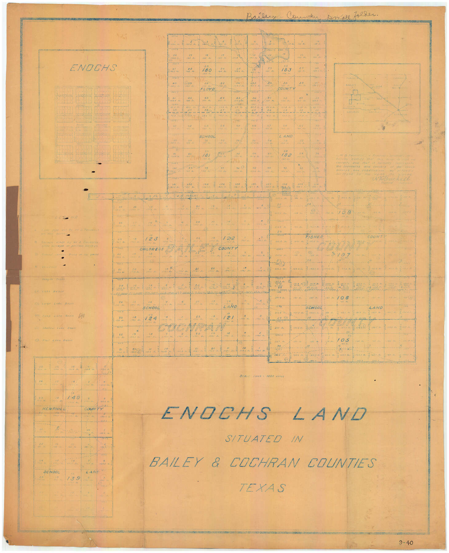
Enochs Land situated in Bailey and Cochran Counties, Texas
9-40
-
Map/Doc
90194
-
Collection
Twichell Survey Records
-
Counties
Bailey Cochran
-
Height x Width
28.9 x 35.6 inches
73.4 x 90.4 cm
Part of: Twichell Survey Records
[Sketch showing B. S. & F. survey number 9, section 9]
![91711, [Sketch showing B. S. & F. survey number 9, section 9], Twichell Survey Records](https://historictexasmaps.com/wmedia_w700/maps/91711-1.tif.jpg)
Print $2.00
- Digital $50.00
[Sketch showing B. S. & F. survey number 9, section 9]
Size 8.7 x 8.1 inches
Map/Doc 91711
Morton Independent School District, Cochran County, Texas

Print $20.00
- Digital $50.00
Morton Independent School District, Cochran County, Texas
Size 26.3 x 23.9 inches
Map/Doc 92519
[Sections 302-313 and sections south of Blocks D and AX]
![92017, [Sections 302-313 and sections south of Blocks D and AX], Twichell Survey Records](https://historictexasmaps.com/wmedia_w700/maps/92017-1.tif.jpg)
Print $20.00
- Digital $50.00
[Sections 302-313 and sections south of Blocks D and AX]
Size 17.5 x 35.6 inches
Map/Doc 92017
[Surveys along San Antonio Road]
![90110, [Surveys along San Antonio Road], Twichell Survey Records](https://historictexasmaps.com/wmedia_w700/maps/90110-1.tif.jpg)
Print $20.00
- Digital $50.00
[Surveys along San Antonio Road]
Size 23.0 x 13.7 inches
Map/Doc 90110
[Sketch showing PSL Block AX and C. C. S. D. & R. G. N. G. RR. Co. Block G]
![90838, [Sketch showing PSL Block AX and C. C. S. D. & R. G. N. G. RR. Co. Block G], Twichell Survey Records](https://historictexasmaps.com/wmedia_w700/maps/90838-2.tif.jpg)
Print $20.00
- Digital $50.00
[Sketch showing PSL Block AX and C. C. S. D. & R. G. N. G. RR. Co. Block G]
Size 25.8 x 16.6 inches
Map/Doc 90838
[Area around J. E. Arnold survey]
![91885, [Area around J. E. Arnold survey], Twichell Survey Records](https://historictexasmaps.com/wmedia_w700/maps/91885-1.tif.jpg)
Print $2.00
- Digital $50.00
[Area around J. E. Arnold survey]
Size 15.3 x 8.2 inches
Map/Doc 91885
[H. & G. N. Block 1]
![90810, [H. & G. N. Block 1], Twichell Survey Records](https://historictexasmaps.com/wmedia_w700/maps/90810-2.tif.jpg)
Print $3.00
- Digital $50.00
[H. & G. N. Block 1]
Size 11.4 x 12.9 inches
Map/Doc 90810
Ochiltree County School Land League Number 204

Print $20.00
- Digital $50.00
Ochiltree County School Land League Number 204
1926
Size 20.8 x 13.7 inches
Map/Doc 92473
[Sketch of surveys in the vicinity of sections 171 and 172 along Pedernales]
![91881, [Sketch of surveys in the vicinity of sections 171 and 172 along Pedernales], Twichell Survey Records](https://historictexasmaps.com/wmedia_w700/maps/91881-1.tif.jpg)
Print $2.00
- Digital $50.00
[Sketch of surveys in the vicinity of sections 171 and 172 along Pedernales]
Size 8.6 x 14.4 inches
Map/Doc 91881
![89627, [Blks. 46 & 47], Twichell Survey Records](https://historictexasmaps.com/wmedia_w700/maps/89627-1.tif.jpg)
Plat Showing Sections 11, 12, 19, and 20, Block A-9 Public School Land, Gaines County, Texas

Print $20.00
- Digital $50.00
Plat Showing Sections 11, 12, 19, and 20, Block A-9 Public School Land, Gaines County, Texas
1958
Size 18.2 x 21.8 inches
Map/Doc 92652
![90713, [Capitol Lands], Twichell Survey Records](https://historictexasmaps.com/wmedia_w700/maps/90713-1.tif.jpg)
You may also like
Flight Mission No. DQO-11K, Frame 24, Galveston County

Print $20.00
- Digital $50.00
Flight Mission No. DQO-11K, Frame 24, Galveston County
1952
Size 18.6 x 22.4 inches
Map/Doc 85221
A New & Correct Map of the Trading Part of the West Indies, including the Seat of War between Gr. Britain and France Likewise the British Empire in America, with the French and Spanish Settlements adjacent thereto

Print $20.00
- Digital $50.00
A New & Correct Map of the Trading Part of the West Indies, including the Seat of War between Gr. Britain and France Likewise the British Empire in America, with the French and Spanish Settlements adjacent thereto
1759
Size 27.4 x 41.4 inches
Map/Doc 93826
Webb County Sketch File 1a

Print $20.00
- Digital $50.00
Webb County Sketch File 1a
1871
Size 23.3 x 18.0 inches
Map/Doc 12623
[East Portion of Lea County] / [Central part of San Miguel County, New Mexico]
![92035, [East Portion of Lea County] / [Central part of San Miguel County, New Mexico], Twichell Survey Records](https://historictexasmaps.com/wmedia_w700/maps/92035-1.tif.jpg)
Print $20.00
- Digital $50.00
[East Portion of Lea County] / [Central part of San Miguel County, New Mexico]
Size 24.9 x 28.9 inches
Map/Doc 92035
Gulf Coast of the United States, Key West to Rio Grande

Print $40.00
Gulf Coast of the United States, Key West to Rio Grande
1863
Size 30.2 x 53.5 inches
Map/Doc 79335
Val Verde County Working Sketch 25

Print $20.00
- Digital $50.00
Val Verde County Working Sketch 25
1934
Size 24.2 x 18.2 inches
Map/Doc 72160
Flight Mission No. BRE-4P, Frame 171, Nueces County

Print $20.00
- Digital $50.00
Flight Mission No. BRE-4P, Frame 171, Nueces County
1956
Size 18.6 x 22.5 inches
Map/Doc 86834
Flight Mission No. BQY-4M, Frame 33, Harris County

Print $20.00
- Digital $50.00
Flight Mission No. BQY-4M, Frame 33, Harris County
1953
Size 18.7 x 22.4 inches
Map/Doc 85248
Cass County Sketch File 23

Print $10.00
- Digital $50.00
Cass County Sketch File 23
1936
Size 14.1 x 8.6 inches
Map/Doc 17435
Nolan County Sketch File A

Print $20.00
- Digital $50.00
Nolan County Sketch File A
Size 22.4 x 19.9 inches
Map/Doc 42170
Flight Mission No. DQN-5K, Frame 146, Calhoun County

Print $20.00
- Digital $50.00
Flight Mission No. DQN-5K, Frame 146, Calhoun County
1953
Size 18.6 x 22.2 inches
Map/Doc 84421
Map No. 2. Eastern States designed to accompany Smith's Geography for School

Print $20.00
- Digital $50.00
Map No. 2. Eastern States designed to accompany Smith's Geography for School
1850
Size 9.6 x 12.1 inches
Map/Doc 93886