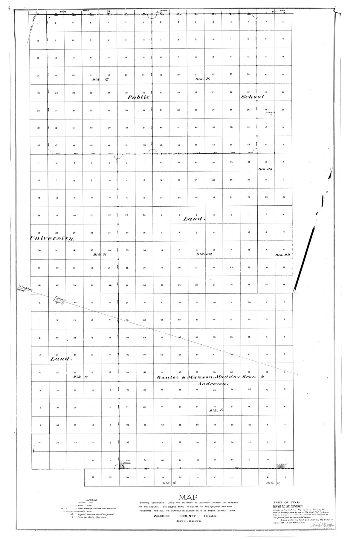
Winkler County Rolled Sketch 5
Map showing connecting lines and traverses as actually coursed and measured on the ground. The object being to locate on the ground and make fieldnotes for all the surveys in Blocks 26 & 27 Public School Land, Winkler County, Texas
-
Map/Doc
10148
-
Collection
General Map Collection
-
Object Dates
1927/4/13 (File Date)
1927/3/21 (Creation Date)
-
People and Organizations
Frank F. Friend (Surveyor/Engineer)
B.F. Kleck (Draftsman)
-
Counties
Winkler Ward
-
Subjects
Surveying Rolled Sketch
-
Height x Width
58.0 x 38.4 inches
147.3 x 97.5 cm
-
Scale
1" = 1000 varas
Part of: General Map Collection
Lynn County Boundary File 5

Print $18.00
- Digital $50.00
Lynn County Boundary File 5
Size 10.2 x 8.3 inches
Map/Doc 56630
Brewster County Rolled Sketch OS

Print $20.00
- Digital $50.00
Brewster County Rolled Sketch OS
Size 17.6 x 21.7 inches
Map/Doc 5323
Falls County Working Sketch 5

Print $40.00
- Digital $50.00
Falls County Working Sketch 5
2008
Size 34.3 x 56.6 inches
Map/Doc 88885
Live Oak County Working Sketch Graphic Index

Print $40.00
- Digital $50.00
Live Oak County Working Sketch Graphic Index
1947
Size 53.7 x 39.4 inches
Map/Doc 76623
Reeves County Working Sketch 17

Print $20.00
- Digital $50.00
Reeves County Working Sketch 17
1961
Size 30.2 x 30.9 inches
Map/Doc 63460
Newton County Sketch File 26

Print $4.00
- Digital $50.00
Newton County Sketch File 26
1893
Size 11.2 x 8.8 inches
Map/Doc 32409
Hardin County Rolled Sketch 11

Print $20.00
- Digital $50.00
Hardin County Rolled Sketch 11
1948
Size 20.8 x 38.6 inches
Map/Doc 6083
Nacogdoches County Sketch File 5

Print $4.00
- Digital $50.00
Nacogdoches County Sketch File 5
1859
Size 12.6 x 8.1 inches
Map/Doc 32243
Flight Mission No. DQN-6K, Frame 7, Calhoun County

Print $20.00
- Digital $50.00
Flight Mission No. DQN-6K, Frame 7, Calhoun County
1953
Size 18.4 x 22.1 inches
Map/Doc 84429
Packery Channel

Print $20.00
- Digital $50.00
Packery Channel
1958
Size 21.1 x 24.3 inches
Map/Doc 3007
Flight Mission No. DQN-2K, Frame 79, Calhoun County

Print $20.00
- Digital $50.00
Flight Mission No. DQN-2K, Frame 79, Calhoun County
1953
Size 16.0 x 16.0 inches
Map/Doc 84271
Harris County Historic Topographic 37

Print $20.00
- Digital $50.00
Harris County Historic Topographic 37
1916
Size 29.8 x 23.0 inches
Map/Doc 65848
You may also like
Hutchinson County Sketch File 45

Print $22.00
- Digital $50.00
Hutchinson County Sketch File 45
1991
Size 11.1 x 8.8 inches
Map/Doc 27354
University Land Field Notes for Blocks A, B, C, D, E, F, G, H, I, and J in Hudspeth County

University Land Field Notes for Blocks A, B, C, D, E, F, G, H, I, and J in Hudspeth County
Map/Doc 81712
Webb County Sketch File 50

Print $20.00
- Digital $50.00
Webb County Sketch File 50
1939
Size 27.4 x 18.6 inches
Map/Doc 12648
Galveston County NRC Article 33.136 Sketch 43

Print $59.00
- Digital $50.00
Galveston County NRC Article 33.136 Sketch 43
2002
Size 24.7 x 36.9 inches
Map/Doc 87156

Map of Lands in King County, Texas owned and leased by the Louisville Land and Cattle Company

Print $20.00
- Digital $50.00
Map of Lands in King County, Texas owned and leased by the Louisville Land and Cattle Company
Size 32.1 x 25.9 inches
Map/Doc 5070
Map showing surveys made on Mustang Island

Print $40.00
- Digital $50.00
Map showing surveys made on Mustang Island
1945
Size 54.7 x 21.0 inches
Map/Doc 2948
Motley County Working Sketch 9

Print $20.00
- Digital $50.00
Motley County Working Sketch 9
1984
Size 32.6 x 28.9 inches
Map/Doc 71214
General Highway Map, Oldham County, Deaf Smith County, Texas

Print $20.00
General Highway Map, Oldham County, Deaf Smith County, Texas
1940
Size 18.3 x 25.2 inches
Map/Doc 79072
Southern Pacific R.R. and connections

Print $20.00
- Digital $50.00
Southern Pacific R.R. and connections
1883
Size 27.9 x 32.5 inches
Map/Doc 94270
El Paso County Working Sketch 58

Print $20.00
- Digital $50.00
El Paso County Working Sketch 58
Size 25.8 x 30.6 inches
Map/Doc 69080
Edwards County Working Sketch 51

Print $20.00
- Digital $50.00
Edwards County Working Sketch 51
1950
Size 21.8 x 22.7 inches
Map/Doc 68927