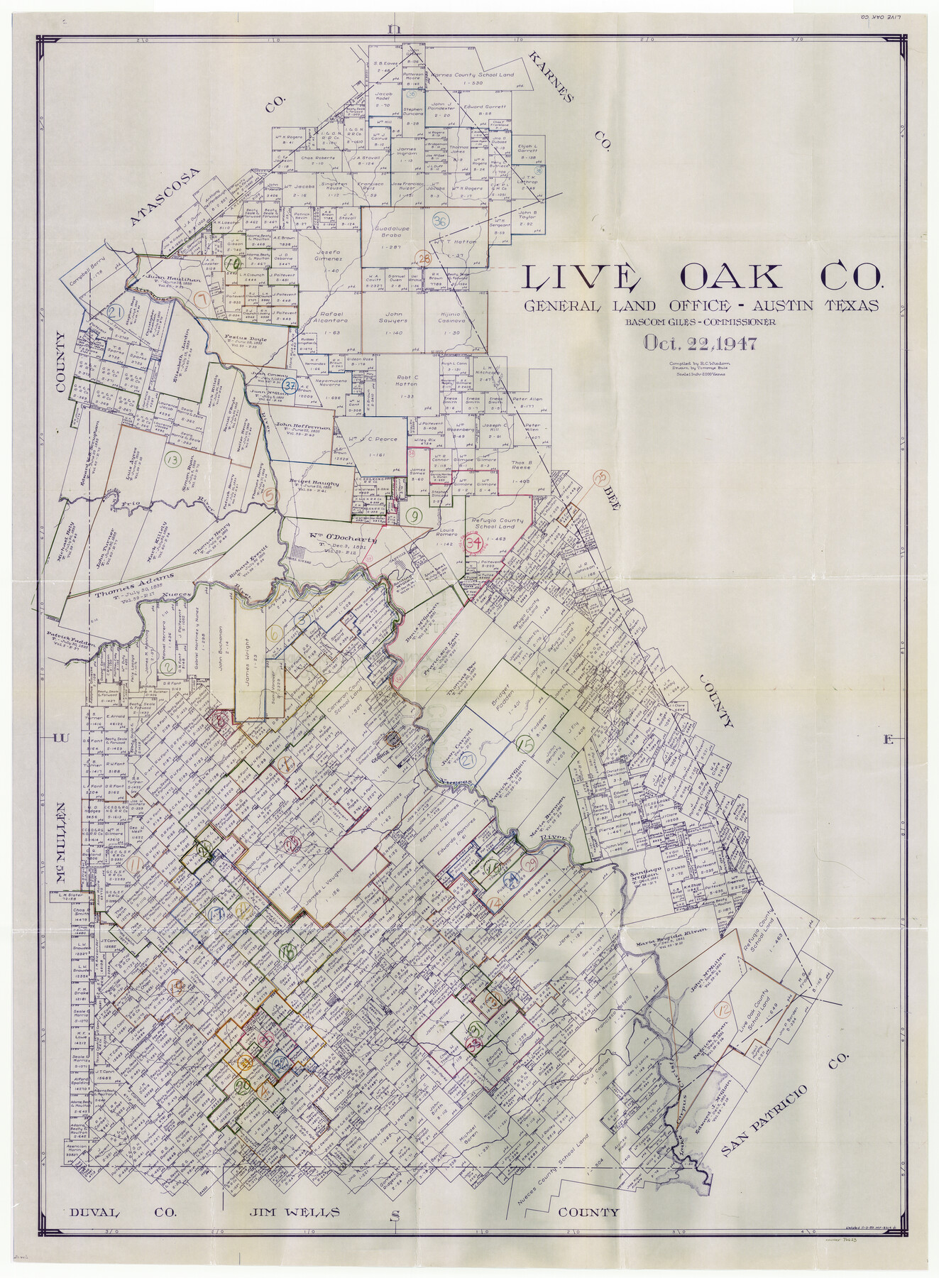
Live Oak County Working Sketch Graphic Index
-
Map/Doc
76623
-
Collection
General Map Collection
-
Object Dates
10/22/1947 (Creation Date)
-
People and Organizations
R.C. Wisdom (Compiler)
Tommye Buie (Draftsman)
-
Counties
Live Oak
-
Subjects
County Surveying Working Sketch
-
Height x Width
53.7 x 39.4 inches
136.4 x 100.1 cm
-
Scale
1" = 2000 varas
Part of: General Map Collection
Gregg County Rolled Sketch RGA

Print $46.00
- Digital $50.00
Gregg County Rolled Sketch RGA
1933
Size 34.3 x 30.6 inches
Map/Doc 9026
Goliad County Working Sketch 25

Print $20.00
- Digital $50.00
Goliad County Working Sketch 25
1994
Size 19.6 x 21.9 inches
Map/Doc 63215
Shackelford County Working Sketch 9

Print $20.00
- Digital $50.00
Shackelford County Working Sketch 9
1974
Size 30.1 x 22.2 inches
Map/Doc 63849
Ward County Working Sketch 16

Print $20.00
- Digital $50.00
Ward County Working Sketch 16
1948
Size 29.6 x 33.9 inches
Map/Doc 72322

Flight Mission No. DIX-10P, Frame 173, Aransas County

Print $20.00
- Digital $50.00
Flight Mission No. DIX-10P, Frame 173, Aransas County
1956
Size 18.5 x 22.3 inches
Map/Doc 83963
Presidio County Rolled Sketch 4

Print $40.00
- Digital $50.00
Presidio County Rolled Sketch 4
Size 19.1 x 69.8 inches
Map/Doc 10733
Flight Mission No. DQN-1K, Frame 137, Calhoun County

Print $20.00
- Digital $50.00
Flight Mission No. DQN-1K, Frame 137, Calhoun County
1953
Size 18.5 x 22.2 inches
Map/Doc 84200
Flight Mission No. CRE-1R, Frame 194, Jackson County

Print $20.00
- Digital $50.00
Flight Mission No. CRE-1R, Frame 194, Jackson County
1956
Size 18.5 x 22.3 inches
Map/Doc 85348
Matagorda County Rolled Sketch 40

Print $20.00
- Digital $50.00
Matagorda County Rolled Sketch 40
Size 24.6 x 27.4 inches
Map/Doc 6704
Pecos County Working Sketch 107

Print $40.00
- Digital $50.00
Pecos County Working Sketch 107
1971
Size 55.3 x 37.4 inches
Map/Doc 71580
Cottle County Working Sketch 14a

Print $20.00
- Digital $50.00
Cottle County Working Sketch 14a
1963
Size 31.2 x 42.1 inches
Map/Doc 68324
You may also like
La Salle County

Print $20.00
- Digital $50.00
La Salle County
1923
Size 47.5 x 42.5 inches
Map/Doc 73215
Hopkins County Working Sketch 3

Print $20.00
- Digital $50.00
Hopkins County Working Sketch 3
1955
Size 24.2 x 20.0 inches
Map/Doc 66228
Hays County Rolled Sketch 20

Print $20.00
- Digital $50.00
Hays County Rolled Sketch 20
Size 14.1 x 36.9 inches
Map/Doc 6176
Houston County Sketch File 1a

Print $4.00
- Digital $50.00
Houston County Sketch File 1a
Size 9.2 x 7.8 inches
Map/Doc 26742
Starr County Working Sketch 28

Print $20.00
- Digital $50.00
Starr County Working Sketch 28
2004
Size 28.0 x 39.6 inches
Map/Doc 83010
Working Sketch in Bailey County

Print $20.00
- Digital $50.00
Working Sketch in Bailey County
1920
Size 11.8 x 29.1 inches
Map/Doc 90255
Flight Mission No. BRA-17M, Frame 6, Jefferson County

Print $20.00
- Digital $50.00
Flight Mission No. BRA-17M, Frame 6, Jefferson County
1953
Size 18.5 x 22.2 inches
Map/Doc 85787
Hudspeth County Working Sketch 7

Print $40.00
- Digital $50.00
Hudspeth County Working Sketch 7
1935
Size 92.4 x 33.6 inches
Map/Doc 66288
Wise County, Texas

Print $20.00
- Digital $50.00
Wise County, Texas
1871
Size 21.9 x 18.7 inches
Map/Doc 766
[Map of Nacogdoches County]
![93368, [Map of Nacogdoches County], General Map Collection](https://historictexasmaps.com/wmedia_w700/maps/93368-1.tif.jpg)
Print $40.00
- Digital $50.00
[Map of Nacogdoches County]
1840
Size 79.3 x 38.0 inches
Map/Doc 93368
Dickens County Rolled Sketch 13

Print $40.00
- Digital $50.00
Dickens County Rolled Sketch 13
1950
Size 44.3 x 53.8 inches
Map/Doc 44296
Map of Africa engraved to illustrate Mitchell's new intermediate geography (Inset 1: Map of Egypt / Inset 2: Liberia and Sierra Leone)

Print $20.00
- Digital $50.00
Map of Africa engraved to illustrate Mitchell's new intermediate geography (Inset 1: Map of Egypt / Inset 2: Liberia and Sierra Leone)
1885
Size 9.0 x 12.2 inches
Map/Doc 93530