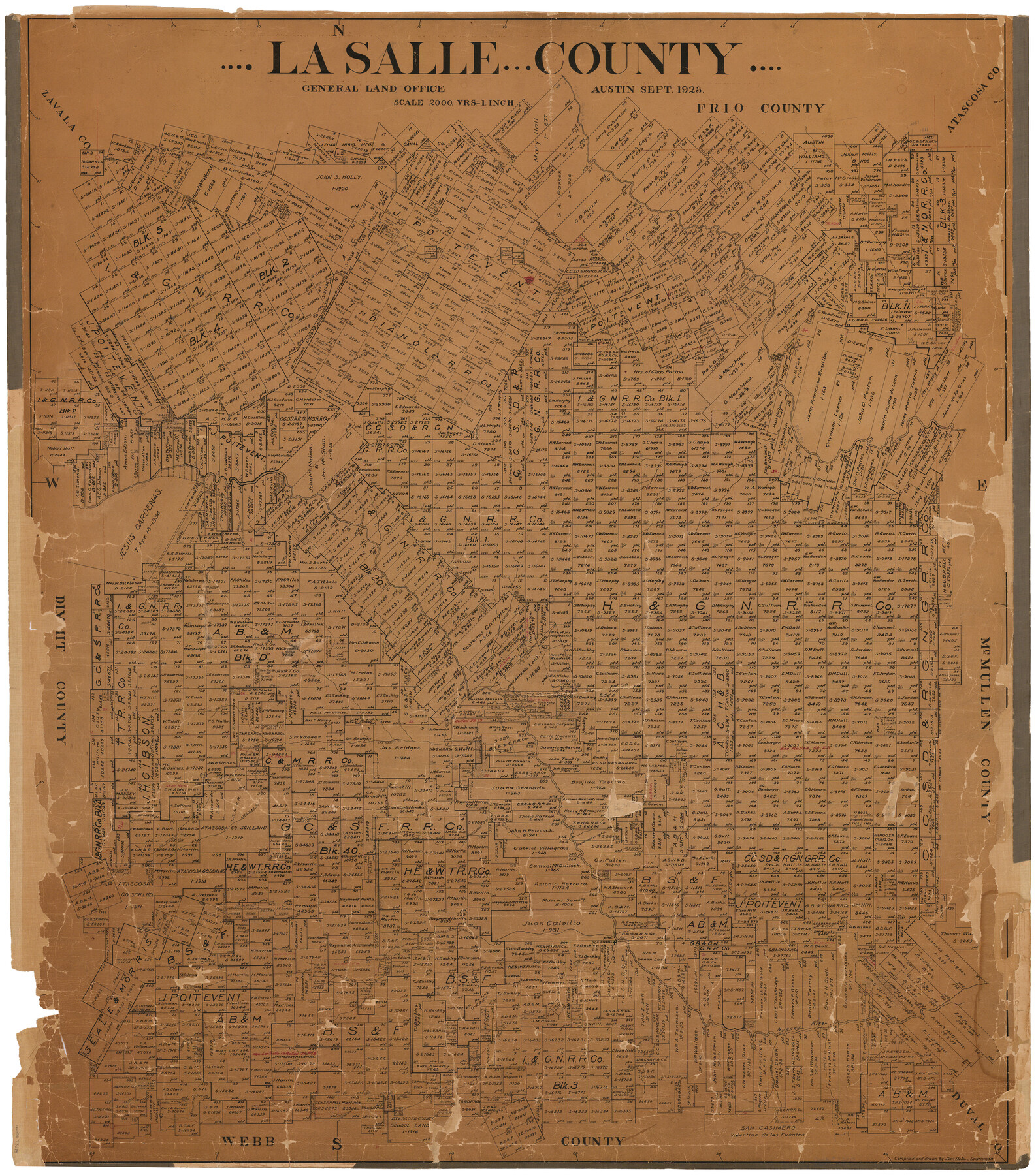
La Salle County
-
Map/Doc
73215
-
Collection
General Map Collection
-
Object Dates
9/1923 (Creation Date)
-
People and Organizations
Texas General Land Office (Publisher)
Tom G. Atlee (Draftsman)
Tom G. Atlee (Compiler)
-
Counties
La Salle
-
Subjects
County
-
Height x Width
47.5 x 42.5 inches
120.7 x 108.0 cm
-
Features
El Paso Road
East Fork of Piedras Creek
West Fork of Piedras Creek
Olmos Creek
La Mota Creek
Lake [East of La Mota Creek]
Fort Ewell
Mojaras Creek
Caiman Creek
El Oso Creek
Los Indios Creek
Tecolote Creek
Chucoreco Creek
Cochino Road
Old El Paso Road
Oso Creek
Laguna Petamosa
Old San Antonio Road
Cristal Hill
Jaboncillos Creek
Laredo Road
Charco Largo Creek
Laguna Retacosa
Encinal
Paco Blanco Road
El Frijol Ranch
Old San Antonio to Laredo Road
San Casimero Creek
Prieto Creek
Charamusca Creek
Harris Lake
Esperanza Creek
Millett
Johny Creek
Sauz Creek
Elm Creek
SAU&G
Gardendale
Dobson
Gayman Creek
Fowlerton
Dull
Los Angeles
Cotulla
Nueces River
Frio River
Mustang Creek
Altito Ranch
Altito Creek
I&GN
Harris Creek
Sutton's Ranch
Second Elm Creek
Live Oak Creek
First Elm Creek
Artesia Wells
Las Raices Creek
Almito Creek
Galapago Creek
Part of: General Map Collection
San Antonio & Surrounding Area

San Antonio & Surrounding Area
1997
Size 36.4 x 46.3 inches
Map/Doc 96867
Terrell County Working Sketch 46

Print $20.00
- Digital $50.00
Terrell County Working Sketch 46
1958
Size 23.8 x 23.4 inches
Map/Doc 62139
Travels to the source of the Missouri River and across the American Continent to the Pacific Ocean - Vol. 1

Travels to the source of the Missouri River and across the American Continent to the Pacific Ocean - Vol. 1
1815
Map/Doc 97411
La Salle County Rolled Sketch 28

Print $90.00
- Digital $50.00
La Salle County Rolled Sketch 28
1956
Size 51.1 x 49.1 inches
Map/Doc 9561
Map of Bastrop County

Print $20.00
- Digital $50.00
Map of Bastrop County
1861
Size 26.3 x 29.0 inches
Map/Doc 3280
Flight Mission No. DQO-11K, Frame 26, Galveston County

Print $20.00
- Digital $50.00
Flight Mission No. DQO-11K, Frame 26, Galveston County
1952
Size 18.8 x 22.5 inches
Map/Doc 85223
Ft. W. & R. G. Ry. Right of Way Map, Chapin to Bluffdale, Hood County, Texas

Print $40.00
- Digital $50.00
Ft. W. & R. G. Ry. Right of Way Map, Chapin to Bluffdale, Hood County, Texas
1918
Size 36.5 x 50.5 inches
Map/Doc 64645
Dallam County Working Sketch 2a

Print $20.00
- Digital $50.00
Dallam County Working Sketch 2a
1886
Size 17.9 x 15.9 inches
Map/Doc 78213
Real County Working Sketch 30

Print $20.00
- Digital $50.00
Real County Working Sketch 30
1947
Size 28.6 x 16.3 inches
Map/Doc 71922
Terrell County Rolled Sketch 46

Print $20.00
- Digital $50.00
Terrell County Rolled Sketch 46
1958
Size 16.1 x 14.6 inches
Map/Doc 7948
Baylor County

Print $20.00
- Digital $50.00
Baylor County
1961
Size 40.6 x 33.0 inches
Map/Doc 77209
San Saba County Working Sketch 9

Print $20.00
- Digital $50.00
San Saba County Working Sketch 9
1983
Size 33.8 x 42.8 inches
Map/Doc 63797
You may also like
Hudspeth County Working Sketch 42

Print $20.00
- Digital $50.00
Hudspeth County Working Sketch 42
1981
Size 34.2 x 36.5 inches
Map/Doc 66327
Collingsworth County Sketch File 3

Print $20.00
- Digital $50.00
Collingsworth County Sketch File 3
1888
Size 32.5 x 27.7 inches
Map/Doc 11130
Crosby County Sketch File 15

Print $20.00
- Digital $50.00
Crosby County Sketch File 15
1903
Size 28.7 x 20.4 inches
Map/Doc 11250
Garza County Sketch File 15

Print $20.00
- Digital $50.00
Garza County Sketch File 15
1902
Size 16.8 x 14.7 inches
Map/Doc 11545
Flight Mission No. CUG-2P, Frame 81, Kleberg County

Print $20.00
- Digital $50.00
Flight Mission No. CUG-2P, Frame 81, Kleberg County
1956
Size 18.7 x 22.2 inches
Map/Doc 86213
Crane County Working Sketch 13

Print $20.00
- Digital $50.00
Crane County Working Sketch 13
1944
Size 23.4 x 17.6 inches
Map/Doc 68290
[Area around Gillespie County, Bastrop County and El Paso County School Land Leagues]
![90866, [Area around Gillespie County, Bastrop County and El Paso County School Land Leagues], Twichell Survey Records](https://historictexasmaps.com/wmedia_w700/maps/90866-2.tif.jpg)
Print $20.00
- Digital $50.00
[Area around Gillespie County, Bastrop County and El Paso County School Land Leagues]
1886
Size 25.7 x 29.8 inches
Map/Doc 90866
Van Zandt County Sketch File 29a

Print $4.00
- Digital $50.00
Van Zandt County Sketch File 29a
1859
Size 14.2 x 6.6 inches
Map/Doc 39455
Webb County Working Sketch 7

Print $20.00
- Digital $50.00
Webb County Working Sketch 7
1909
Size 29.7 x 20.3 inches
Map/Doc 72372
Galveston County Boundary File 32a

Print $10.00
- Digital $50.00
Galveston County Boundary File 32a
Size 11.4 x 8.9 inches
Map/Doc 53666
Winkler Co., Tex., standard single county oil development survey

Print $20.00
- Digital $50.00
Winkler Co., Tex., standard single county oil development survey
Size 14.5 x 16.4 inches
Map/Doc 91972
King County Sketch File 8

Print $46.00
- Digital $50.00
King County Sketch File 8
Size 8.8 x 8.9 inches
Map/Doc 29060