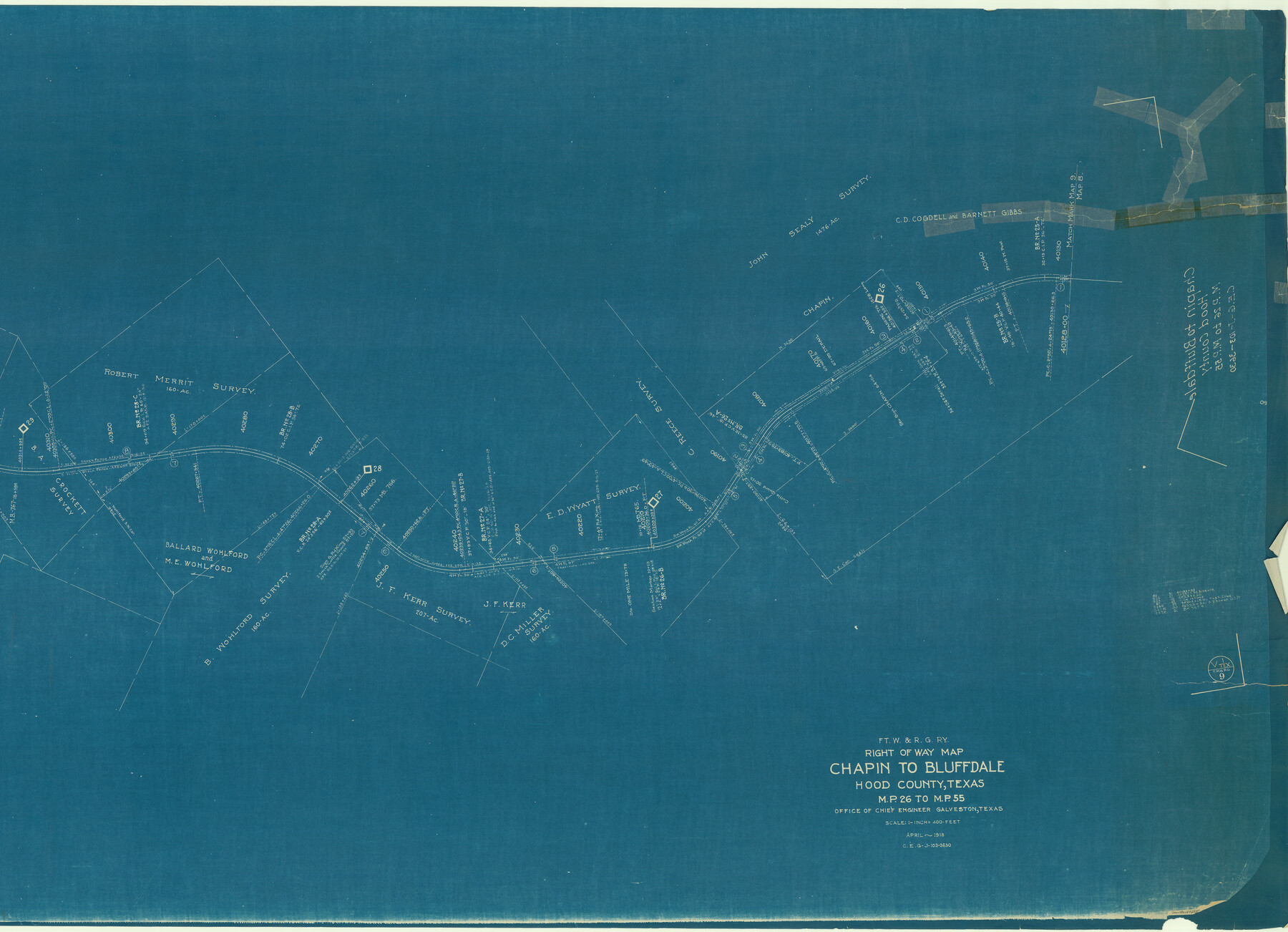
Ft. W. & R. G. Ry. Right of Way Map, Chapin to Bluffdale, Hood County, Texas
M.P. 26 to M.P. 55
Z-2-167
-
Map/Doc
64645
-
Collection
General Map Collection
-
Object Dates
1918 (Creation Date)
-
Counties
Hood
-
Subjects
Railroads
-
Height x Width
36.5 x 50.5 inches
92.7 x 128.3 cm
-
Medium
blueprint/diazo
-
Scale
1" = 400 feet
-
Comments
Segment 4; see counter nos. 64643 through 64644 for other segments and counter no. 64646 for sheet 2.
-
Features
FW&RG
Chapin
Part of: General Map Collection
Morris County Rolled Sketch 2A

Print $20.00
- Digital $50.00
Morris County Rolled Sketch 2A
Size 24.2 x 19.1 inches
Map/Doc 10243
Wharton County Working Sketch 19

Print $20.00
- Digital $50.00
Wharton County Working Sketch 19
1940
Size 21.4 x 23.0 inches
Map/Doc 72483
Jasper County Working Sketch 33

Print $20.00
- Digital $50.00
Jasper County Working Sketch 33
1999
Size 30.4 x 17.5 inches
Map/Doc 66495
Grimes County Rolled Sketch 1

Print $20.00
- Digital $50.00
Grimes County Rolled Sketch 1
1945
Size 34.6 x 35.0 inches
Map/Doc 9007
Nautical Chart 892-SC - Intracoastal Waterway - Carlos Bay to Redfish Bay including Copano Bay, Texas

Print $40.00
- Digital $50.00
Nautical Chart 892-SC - Intracoastal Waterway - Carlos Bay to Redfish Bay including Copano Bay, Texas
1972
Size 16.6 x 52.1 inches
Map/Doc 73441
Brewster County Working Sketch 48

Print $20.00
- Digital $50.00
Brewster County Working Sketch 48
1949
Size 28.9 x 23.7 inches
Map/Doc 67582
Sherman County Rolled Sketch 6

Print $20.00
- Digital $50.00
Sherman County Rolled Sketch 6
1919
Size 37.3 x 36.0 inches
Map/Doc 10731
Flight Mission No. BRE-1P, Frame 115, Nueces County

Print $20.00
- Digital $50.00
Flight Mission No. BRE-1P, Frame 115, Nueces County
1956
Size 18.4 x 22.2 inches
Map/Doc 86681
Live Oak County Working Sketch 34

Print $20.00
- Digital $50.00
Live Oak County Working Sketch 34
Size 31.0 x 42.6 inches
Map/Doc 78469
Flight Mission No. BQR-22K, Frame 47, Brazoria County

Print $20.00
- Digital $50.00
Flight Mission No. BQR-22K, Frame 47, Brazoria County
1953
Size 18.8 x 22.4 inches
Map/Doc 84131
[Sketch for Mineral Application 1487 -Big Wichita River, Ernest R. Smith]
![65684, [Sketch for Mineral Application 1487 -Big Wichita River, Ernest R. Smith], General Map Collection](https://historictexasmaps.com/wmedia_w700/maps/65684.tif.jpg)
Print $40.00
- Digital $50.00
[Sketch for Mineral Application 1487 -Big Wichita River, Ernest R. Smith]
1918
Size 32.2 x 130.1 inches
Map/Doc 65684
Terrell County Working Sketch 65

Print $40.00
- Digital $50.00
Terrell County Working Sketch 65
1972
Size 49.0 x 44.8 inches
Map/Doc 69586
You may also like
Schleicher County Sketch File 21

Print $40.00
- Digital $50.00
Schleicher County Sketch File 21
1936
Size 14.5 x 15.2 inches
Map/Doc 36510
Cooke County Sketch File 29

Print $16.00
- Digital $50.00
Cooke County Sketch File 29
1873
Size 8.2 x 11.0 inches
Map/Doc 19283
[Blocks O5, A, T1, T2, T3 and vicinity]
![92201, [Blocks O5, A, T1, T2, T3 and vicinity], Twichell Survey Records](https://historictexasmaps.com/wmedia_w700/maps/92201-1.tif.jpg)
Print $20.00
- Digital $50.00
[Blocks O5, A, T1, T2, T3 and vicinity]
Size 20.2 x 23.0 inches
Map/Doc 92201
Kinney County Rolled Sketch 13

Print $20.00
- Digital $50.00
Kinney County Rolled Sketch 13
1949
Size 24.9 x 37.4 inches
Map/Doc 77562
1938 Tydol Trails New York

Print $20.00
- Digital $50.00
1938 Tydol Trails New York
1938
Size 27.2 x 31.8 inches
Map/Doc 97111
Presidio County Working Sketch 9a

Print $20.00
- Digital $50.00
Presidio County Working Sketch 9a
1933
Size 22.3 x 16.7 inches
Map/Doc 78284
Cameron County Sketch File 7

Print $146.00
- Digital $50.00
Cameron County Sketch File 7
1980
Size 14.3 x 8.7 inches
Map/Doc 17042
Gaines County Rolled Sketch 17A

Print $40.00
- Digital $50.00
Gaines County Rolled Sketch 17A
1950
Size 23.9 x 61.6 inches
Map/Doc 9040
Harris County Working Sketch 14

Print $20.00
- Digital $50.00
Harris County Working Sketch 14
Size 18.9 x 17.4 inches
Map/Doc 65906
Flight Mission No. DQO-8K, Frame 111, Galveston County

Print $20.00
- Digital $50.00
Flight Mission No. DQO-8K, Frame 111, Galveston County
1952
Size 18.6 x 22.3 inches
Map/Doc 85193
Nueces County Rolled Sketch 93

Print $161.00
Nueces County Rolled Sketch 93
1983
Size 37.3 x 24.2 inches
Map/Doc 7029
Flight Mission No. CGI-3N, Frame 72, Cameron County

Print $20.00
- Digital $50.00
Flight Mission No. CGI-3N, Frame 72, Cameron County
1954
Size 18.5 x 22.3 inches
Map/Doc 84566