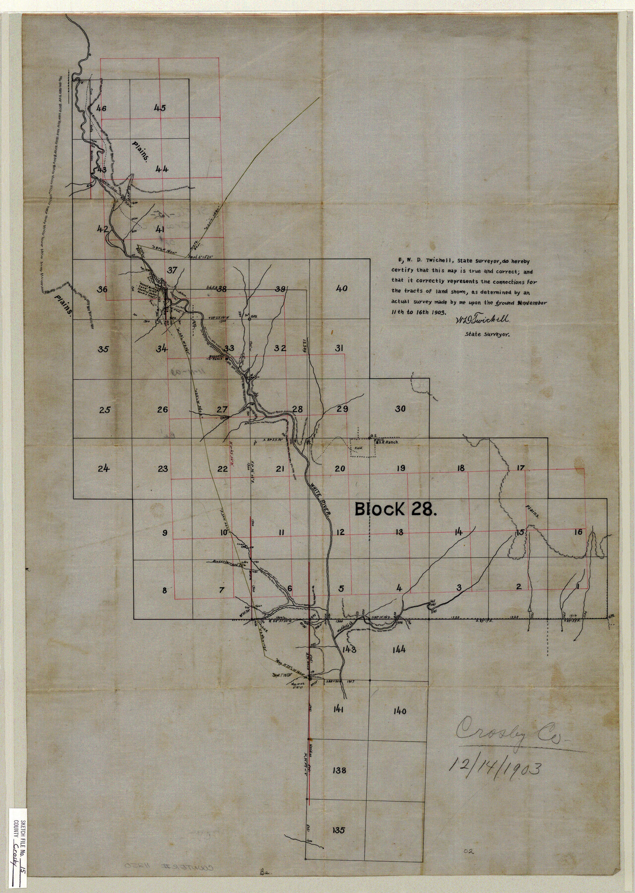
Crosby County Sketch File 15
[Sketch of surveys in Block 28 east of Crosbyton]
-
Map/Doc
11250
-
Collection
General Map Collection
-
Object Dates
11/1903 (Creation Date)
12/14/1903 (File Date)
11/11-16/1903 (Survey Date)
-
People and Organizations
W.D. Twichell (Surveyor/Engineer)
-
Counties
Crosby
-
Subjects
Surveying Sketch File
-
Height x Width
28.7 x 20.4 inches
72.9 x 51.8 cm
-
Medium
paper, manuscript
-
Features
Bassett's Ranch
McNeil's Ranch
White River
Brokenborough Creek
Waddell's Creek
Part of: General Map Collection
Angelina County Working Sketch 4

Print $20.00
- Digital $50.00
Angelina County Working Sketch 4
1910
Size 15.0 x 13.3 inches
Map/Doc 67084
Garza County Rolled Sketch 5

Print $40.00
- Digital $50.00
Garza County Rolled Sketch 5
1906
Size 37.2 x 48.0 inches
Map/Doc 9050
Concho County Sketch File 40

Print $26.00
- Digital $50.00
Concho County Sketch File 40
1949
Size 11.3 x 8.7 inches
Map/Doc 19194
Montague County Sketch File 22

Print $20.00
- Digital $50.00
Montague County Sketch File 22
1927
Size 27.7 x 20.1 inches
Map/Doc 12107
Controlled Mosaic by Jack Amman Photogrammetric Engineers, Inc - Sheet 7

Print $20.00
- Digital $50.00
Controlled Mosaic by Jack Amman Photogrammetric Engineers, Inc - Sheet 7
1954
Size 20.0 x 24.0 inches
Map/Doc 83451
Travis County Rolled Sketch 45

Print $20.00
- Digital $50.00
Travis County Rolled Sketch 45
Size 19.1 x 25.0 inches
Map/Doc 8042
Flight Mission No. BQR-5K, Frame 69, Brazoria County

Print $20.00
- Digital $50.00
Flight Mission No. BQR-5K, Frame 69, Brazoria County
1952
Size 18.8 x 22.4 inches
Map/Doc 84014
Anderson County Sketch File 18

Print $40.00
- Digital $50.00
Anderson County Sketch File 18
1880
Size 16.0 x 13.5 inches
Map/Doc 10801
Liberty County Working Sketch 91

Print $40.00
- Digital $50.00
Liberty County Working Sketch 91
1919
Size 48.4 x 43.0 inches
Map/Doc 65459

Loving County Working Sketch 8

Print $40.00
- Digital $50.00
Loving County Working Sketch 8
1952
Size 21.9 x 56.6 inches
Map/Doc 70640
Coke County Rolled Sketch 4

Print $20.00
- Digital $50.00
Coke County Rolled Sketch 4
Size 44.6 x 37.0 inches
Map/Doc 8624
You may also like
Menard County Sketch File 28

Print $8.00
- Digital $50.00
Menard County Sketch File 28
1955
Size 11.0 x 8.6 inches
Map/Doc 31567
John DePauw Lands

Print $20.00
- Digital $50.00
John DePauw Lands
1954
Size 22.0 x 18.8 inches
Map/Doc 92503
Dominguez Empresario Colony. February 6, 1829

Print $20.00
Dominguez Empresario Colony. February 6, 1829
2020
Size 17.2 x 21.7 inches
Map/Doc 95992
Hudspeth County Working Sketch 18

Print $40.00
- Digital $50.00
Hudspeth County Working Sketch 18
1957
Size 22.2 x 113.1 inches
Map/Doc 66300
Harris County Boundary File 39

Print $40.00
- Digital $50.00
Harris County Boundary File 39
Size 9.1 x 3.9 inches
Map/Doc 54306
Flight Mission No. DCL-6C, Frame 14, Kenedy County

Print $20.00
- Digital $50.00
Flight Mission No. DCL-6C, Frame 14, Kenedy County
1943
Size 18.7 x 22.4 inches
Map/Doc 85871
[Surveys in Austin's Colony along the Brazos River]
![213, [Surveys in Austin's Colony along the Brazos River], General Map Collection](https://historictexasmaps.com/wmedia_w700/maps/213.tif.jpg)
Print $20.00
- Digital $50.00
[Surveys in Austin's Colony along the Brazos River]
1824
Size 12.9 x 14.5 inches
Map/Doc 213
Kaufman County Sketch File 20

Print $20.00
- Digital $50.00
Kaufman County Sketch File 20
1950
Size 23.2 x 34.8 inches
Map/Doc 11908
Approaches to Galveston Bay

Print $40.00
- Digital $50.00
Approaches to Galveston Bay
1982
Size 53.1 x 36.7 inches
Map/Doc 69884
Trinity River, Barnes Bridge Sheet/East Fork of Trinity River

Print $4.00
- Digital $50.00
Trinity River, Barnes Bridge Sheet/East Fork of Trinity River
1936
Size 29.5 x 22.7 inches
Map/Doc 65192
[Beaumont, Sour Lake and Western Ry. Right of Way and Alignment - Frisco]
![64122, [Beaumont, Sour Lake and Western Ry. Right of Way and Alignment - Frisco], General Map Collection](https://historictexasmaps.com/wmedia_w700/maps/64122.tif.jpg)
Print $20.00
- Digital $50.00
[Beaumont, Sour Lake and Western Ry. Right of Way and Alignment - Frisco]
1910
Size 19.8 x 45.9 inches
Map/Doc 64122
Andrews County

Print $40.00
- Digital $50.00
Andrews County
1951
Size 42.7 x 54.5 inches
Map/Doc 1769