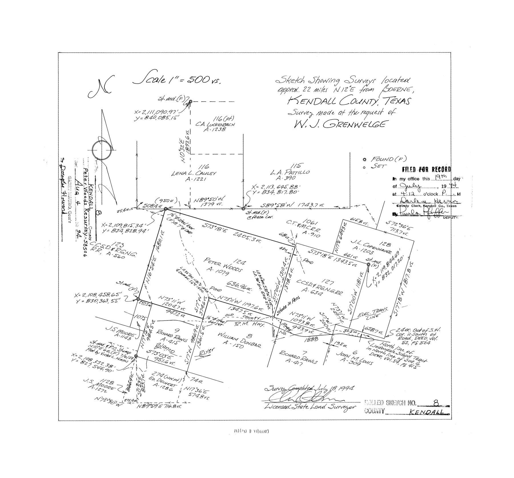
Kendall County Rolled Sketch 8
Map showing corrected surveys made in an area approx. 22 miles N 12° E from Boerne, Kendall County, Texas - survey made at the request of W.J. Grenwelge
-
Map/Doc
6461
-
Collection
General Map Collection
-
Object Dates
1994/7/18 (Creation Date)
1994/8/4 (File Date)
-
People and Organizations
Charles Ottmers (Surveyor/Engineer)
-
Counties
Kendall
-
Subjects
Surveying Rolled Sketch
-
Height x Width
17.0 x 18.3 inches
43.2 x 46.5 cm
-
Medium
mylar, print
-
Scale
1" = 500 varas
Part of: General Map Collection
Reagan County Sketch File 28

Print $20.00
- Digital $50.00
Reagan County Sketch File 28
1951
Size 29.6 x 21.7 inches
Map/Doc 12224
Bee County Sketch File 8b

Print $4.00
- Digital $50.00
Bee County Sketch File 8b
Size 11.5 x 8.1 inches
Map/Doc 14287
La Salle County Rolled Sketch 19

Print $20.00
- Digital $50.00
La Salle County Rolled Sketch 19
1953
Size 31.8 x 30.0 inches
Map/Doc 6583
Sabine County Sketch File 8

Print $4.00
Sabine County Sketch File 8
1894
Size 9.7 x 8.4 inches
Map/Doc 35622
Webb County Rolled Sketch 42

Print $20.00
- Digital $50.00
Webb County Rolled Sketch 42
1941
Size 25.2 x 37.1 inches
Map/Doc 8197

San Saba County Sketch File 2

Print $6.00
- Digital $50.00
San Saba County Sketch File 2
1854
Size 4.8 x 7.4 inches
Map/Doc 36405
Wise County Sketch File 54

Print $22.00
- Digital $50.00
Wise County Sketch File 54
2012
Size 11.0 x 8.5 inches
Map/Doc 93553
Montague County Working Sketch 18

Print $20.00
- Digital $50.00
Montague County Working Sketch 18
1948
Size 27.9 x 21.4 inches
Map/Doc 71084
Val Verde County Sketch File 45

Print $20.00
- Digital $50.00
Val Verde County Sketch File 45
1938
Size 21.3 x 16.5 inches
Map/Doc 12586
Outer Continental Shelf Leasing Maps (Texas Offshore Operations)

Print $20.00
- Digital $50.00
Outer Continental Shelf Leasing Maps (Texas Offshore Operations)
1954
Size 11.6 x 12.3 inches
Map/Doc 75835
Pecos County Working Sketch 89

Print $20.00
- Digital $50.00
Pecos County Working Sketch 89
1964
Size 46.5 x 34.2 inches
Map/Doc 78216
You may also like
Flight Mission No. BRA-8M, Frame 88, Jefferson County

Print $20.00
- Digital $50.00
Flight Mission No. BRA-8M, Frame 88, Jefferson County
1953
Size 18.6 x 22.3 inches
Map/Doc 85608

Index sheet to accompany map of survey for connecting the inland waters along margin of the Gulf of Mexico from Donaldsonville in Louisiana to the Rio Grande River in Texas

Print $20.00
- Digital $50.00
Index sheet to accompany map of survey for connecting the inland waters along margin of the Gulf of Mexico from Donaldsonville in Louisiana to the Rio Grande River in Texas
1874
Size 18.1 x 26.9 inches
Map/Doc 72694
Gaines County Rolled Sketch J

Print $40.00
- Digital $50.00
Gaines County Rolled Sketch J
Size 26.6 x 73.8 inches
Map/Doc 9013
Flight Mission No. DQN-5K, Frame 74, Calhoun County

Print $20.00
- Digital $50.00
Flight Mission No. DQN-5K, Frame 74, Calhoun County
1953
Size 18.5 x 22.2 inches
Map/Doc 84407
Montgomery County Working Sketch 76

Print $20.00
- Digital $50.00
Montgomery County Working Sketch 76
Size 16.5 x 18.3 inches
Map/Doc 78191
Flight Mission No. BRA-8M, Frame 148, Jefferson County

Print $20.00
- Digital $50.00
Flight Mission No. BRA-8M, Frame 148, Jefferson County
1953
Size 18.8 x 22.5 inches
Map/Doc 85640
Donley County Sketch File B10

Print $24.00
- Digital $50.00
Donley County Sketch File B10
1938
Size 14.3 x 9.1 inches
Map/Doc 21272
Brewster County Working Sketch 97

Print $20.00
- Digital $50.00
Brewster County Working Sketch 97
1978
Size 31.7 x 47.0 inches
Map/Doc 67697
Copy of Surveyor's Field Book, Morris Browning - In Blocks 7, 5 & 4, I&GNRRCo., Hutchinson and Carson Counties, Texas

Print $2.00
- Digital $50.00
Copy of Surveyor's Field Book, Morris Browning - In Blocks 7, 5 & 4, I&GNRRCo., Hutchinson and Carson Counties, Texas
1888
Size 6.9 x 8.9 inches
Map/Doc 62285
El Paso County Working Sketch 23

Print $20.00
- Digital $50.00
El Paso County Working Sketch 23
1961
Size 22.3 x 28.8 inches
Map/Doc 69045
Austin's Register of Families Vol. 1

Austin's Register of Families Vol. 1
Size 14.0 x 10.2 inches
Map/Doc 94249