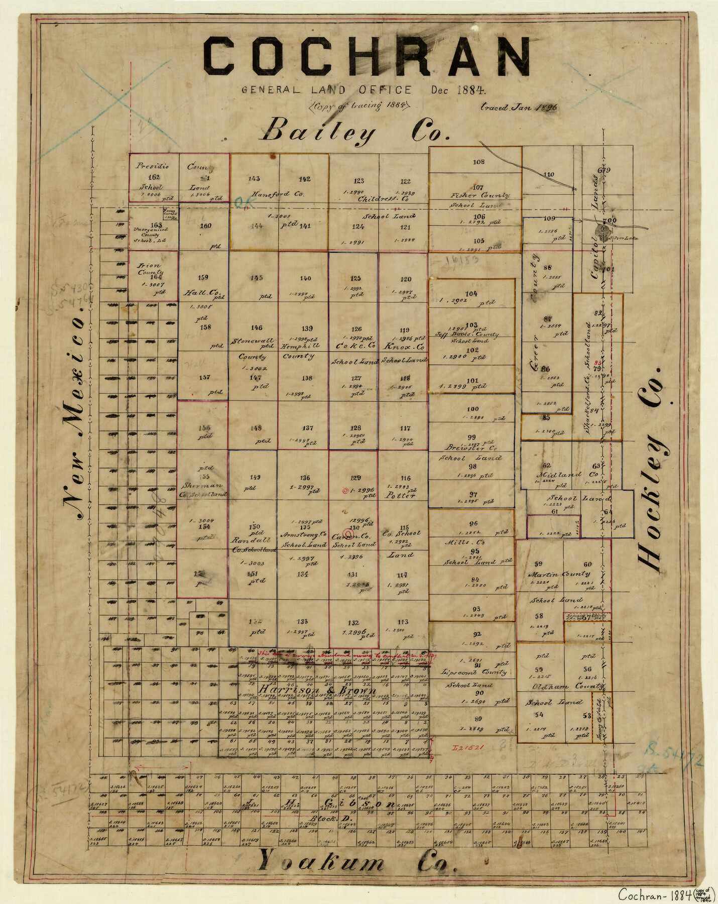
Cochran
-
Map/Doc
3405
-
Collection
General Map Collection
-
Object Dates
12/1884 (Creation Date)
-
Counties
Cochran
-
Subjects
County
-
Height x Width
22.5 x 17.9 inches
57.2 x 45.5 cm
-
Comments
Note on map: Copy of tracing 1884. Traced January 1896".
-
Features
Silver Lake
Part of: General Map Collection
United States - Gulf Coast - Aransas Pass and Corpus Christi Bay with the coast to latitude 27° 12' Texas

Print $20.00
- Digital $50.00
United States - Gulf Coast - Aransas Pass and Corpus Christi Bay with the coast to latitude 27° 12' Texas
1913
Size 27.7 x 18.4 inches
Map/Doc 72795
Nueces County Sketch File 37

Print $2.00
- Digital $50.00
Nueces County Sketch File 37
1913
Size 11.2 x 8.6 inches
Map/Doc 32614

Jackson County Working Sketch 9

Print $20.00
- Digital $50.00
Jackson County Working Sketch 9
1982
Size 13.3 x 31.4 inches
Map/Doc 66457
Baylor County Working Sketch 3

Print $20.00
- Digital $50.00
Baylor County Working Sketch 3
1929
Size 37.8 x 36.5 inches
Map/Doc 67288
Hutchinson County Working Sketch 9

Print $20.00
- Digital $50.00
Hutchinson County Working Sketch 9
1920
Size 38.5 x 43.3 inches
Map/Doc 66367
Jeff Davis County Rolled Sketch 42

Print $20.00
- Digital $50.00
Jeff Davis County Rolled Sketch 42
1998
Size 26.8 x 18.9 inches
Map/Doc 76415
Fannin County Sketch File 7

Print $40.00
- Digital $50.00
Fannin County Sketch File 7
1857
Size 16.8 x 13.5 inches
Map/Doc 22451
Bosque County Sketch File 10

Print $4.00
- Digital $50.00
Bosque County Sketch File 10
1859
Size 12.9 x 8.2 inches
Map/Doc 14757
Flight Mission No. BRA-6M, Frame 147, Jefferson County

Print $20.00
- Digital $50.00
Flight Mission No. BRA-6M, Frame 147, Jefferson County
1953
Size 18.6 x 22.4 inches
Map/Doc 85448
Cottle County

Print $20.00
- Digital $50.00
Cottle County
1971
Size 42.5 x 35.7 inches
Map/Doc 73118
Galveston County Rolled Sketch 43A

Print $20.00
- Digital $50.00
Galveston County Rolled Sketch 43A
Size 16.2 x 20.3 inches
Map/Doc 76005
You may also like
[Surveys in Austin's Colony along the Navasota River and Ten Mile Creek]
![80, [Surveys in Austin's Colony along the Navasota River and Ten Mile Creek], General Map Collection](https://historictexasmaps.com/wmedia_w700/maps/80.tif.jpg)
Print $20.00
- Digital $50.00
[Surveys in Austin's Colony along the Navasota River and Ten Mile Creek]
1821
Size 29.2 x 18.0 inches
Map/Doc 80
Upper Galveston Bay, Houston Ship Channel, Dollar Pt. to Atkinson I.

Print $40.00
- Digital $50.00
Upper Galveston Bay, Houston Ship Channel, Dollar Pt. to Atkinson I.
1976
Size 49.3 x 36.5 inches
Map/Doc 69897
Brewster County Sketch File S-36

Print $80.00
- Digital $50.00
Brewster County Sketch File S-36
1986
Size 14.4 x 8.8 inches
Map/Doc 15865
Part of Block T-2 Lamb County Texas

Print $20.00
- Digital $50.00
Part of Block T-2 Lamb County Texas
1952
Size 14.3 x 24.6 inches
Map/Doc 92182
Walker County Sketch File 5

Print $4.00
- Digital $50.00
Walker County Sketch File 5
Size 13.5 x 8.3 inches
Map/Doc 39555
Young County Working Sketch 23

Print $20.00
- Digital $50.00
Young County Working Sketch 23
1965
Size 31.3 x 22.3 inches
Map/Doc 62046
Brewster County Rolled Sketch 101

Print $40.00
- Digital $50.00
Brewster County Rolled Sketch 101
1927
Size 63.0 x 46.2 inches
Map/Doc 10648
Big Inch and Little Big Inch Pipelines

Big Inch and Little Big Inch Pipelines
2022
Size 8.5 x 11.0 inches
Map/Doc 97089

Deaf Smith County, Texas

Print $20.00
- Digital $50.00
Deaf Smith County, Texas
1880
Size 22.9 x 25.6 inches
Map/Doc 678
Flight Mission No. CGI-3N, Frame 77, Cameron County

Print $20.00
- Digital $50.00
Flight Mission No. CGI-3N, Frame 77, Cameron County
1954
Size 18.6 x 22.2 inches
Map/Doc 84571
Map showing eight tidal areas in Oso Bay and Oso Creek, Nueces County, Texas offered for Mineral Development

Print $20.00
- Digital $50.00
Map showing eight tidal areas in Oso Bay and Oso Creek, Nueces County, Texas offered for Mineral Development
1936
Size 17.9 x 29.7 inches
Map/Doc 2067