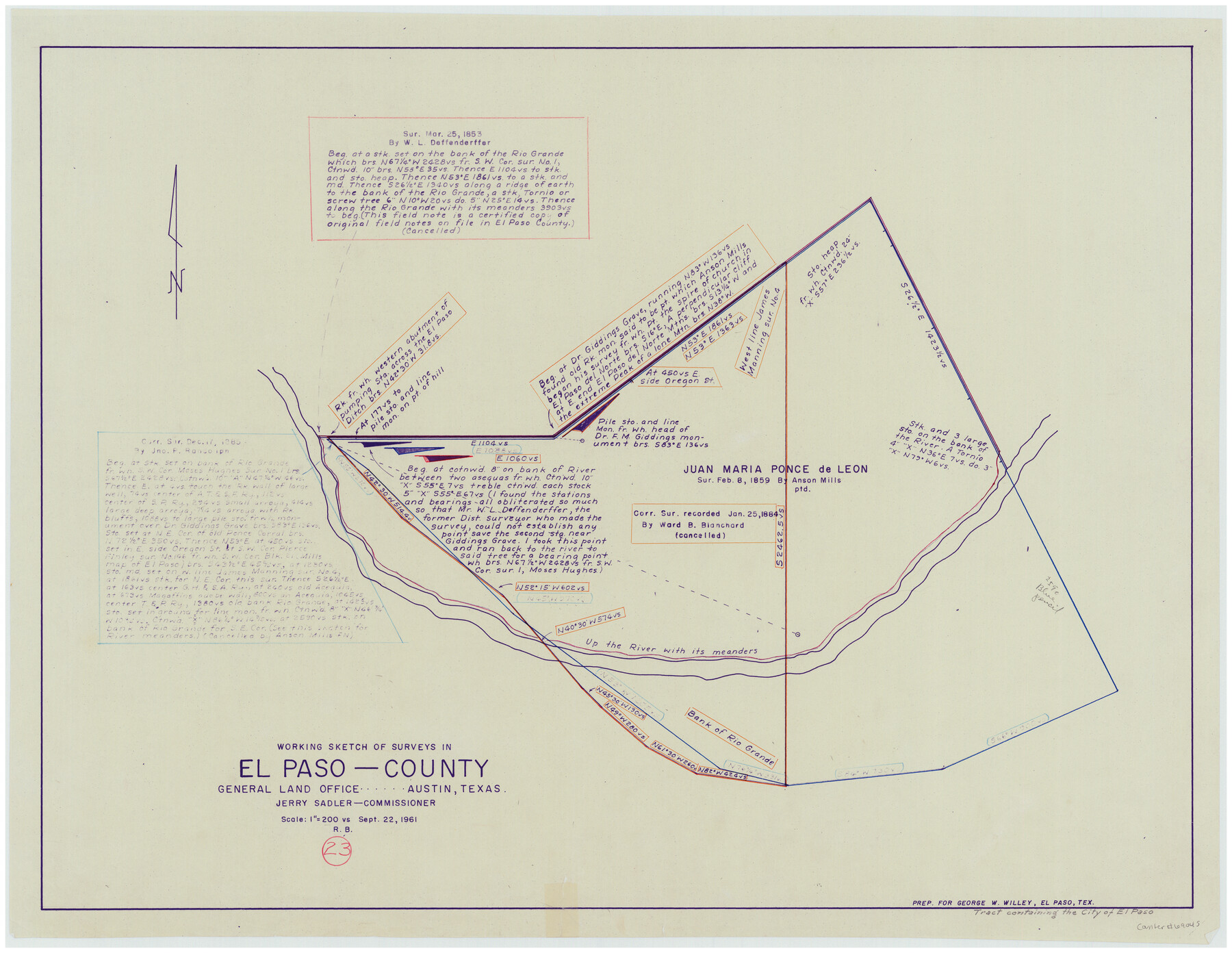
El Paso County Working Sketch 23
-
Map/Doc
69045
-
Collection
General Map Collection
-
Object Dates
9/22/1961 (Creation Date)
-
People and Organizations
Roy Buckholts (Draftsman)
-
Counties
El Paso
-
Subjects
Surveying Working Sketch
-
Height x Width
22.3 x 28.8 inches
56.6 x 73.2 cm
-
Scale
1" = 200 varas
Part of: General Map Collection
Nueces County Rolled Sketch 119

Print $90.00
Nueces County Rolled Sketch 119
1994
Size 26.1 x 36.5 inches
Map/Doc 7151
Flight Mission No. DAG-23K, Frame 58, Matagorda County

Print $20.00
- Digital $50.00
Flight Mission No. DAG-23K, Frame 58, Matagorda County
1953
Size 18.4 x 22.3 inches
Map/Doc 86485
The American Union Railroad Map of the United States, British Possessions, West Indies, Mexico, and Central America

Print $40.00
- Digital $50.00
The American Union Railroad Map of the United States, British Possessions, West Indies, Mexico, and Central America
1873
Size 40.2 x 58.2 inches
Map/Doc 97124
Dimmit County

Print $40.00
- Digital $50.00
Dimmit County
1916
Size 40.6 x 48.0 inches
Map/Doc 78341
Reagan County Working Sketch 35

Print $40.00
- Digital $50.00
Reagan County Working Sketch 35
1966
Size 29.7 x 51.4 inches
Map/Doc 71877
Houston County Sketch File 12

Print $4.00
- Digital $50.00
Houston County Sketch File 12
1849
Size 8.2 x 14.7 inches
Map/Doc 26773
Flight Mission No. CRC-3R, Frame 196, Chambers County

Print $20.00
- Digital $50.00
Flight Mission No. CRC-3R, Frame 196, Chambers County
1956
Size 18.7 x 22.3 inches
Map/Doc 84851
Jack County Sketch File 37

Print $4.00
- Digital $50.00
Jack County Sketch File 37
1963
Size 3.5 x 7.6 inches
Map/Doc 27615
Nueces County NRC Article 33.136 Sketch 5

Print $48.00
- Digital $50.00
Nueces County NRC Article 33.136 Sketch 5
2002
Size 22.9 x 34.7 inches
Map/Doc 78666
Current Miscellaneous File 114

Print $16.00
- Digital $50.00
Current Miscellaneous File 114
1985
Size 8.9 x 11.3 inches
Map/Doc 74803
Erath County Working Sketch 6

Print $20.00
- Digital $50.00
Erath County Working Sketch 6
1920
Size 40.9 x 33.1 inches
Map/Doc 69087
Bandera County Rolled Sketch 10

Print $20.00
- Digital $50.00
Bandera County Rolled Sketch 10
1998
Size 35.4 x 38.1 inches
Map/Doc 8440
You may also like
Fayette County Working Sketch 3

Print $20.00
- Digital $50.00
Fayette County Working Sketch 3
1980
Size 29.0 x 36.3 inches
Map/Doc 69167
Working Sketch in Terrell County

Print $3.00
- Digital $50.00
Working Sketch in Terrell County
1927
Size 17.1 x 9.5 inches
Map/Doc 92911
Map of Montague County

Print $20.00
- Digital $50.00
Map of Montague County
1868
Size 19.9 x 16.9 inches
Map/Doc 3888
Potter County Boundary File 3c

Print $6.00
- Digital $50.00
Potter County Boundary File 3c
Size 11.4 x 8.8 inches
Map/Doc 57984
Map of the United States with its territories: also Mexico and the West Indies

Print $20.00
- Digital $50.00
Map of the United States with its territories: also Mexico and the West Indies
1851
Size 40.1 x 36.7 inches
Map/Doc 93925
Presidio County Rolled Sketch 56

Print $20.00
- Digital $50.00
Presidio County Rolled Sketch 56
1915
Size 21.8 x 17.1 inches
Map/Doc 7349
Milam County Working Sketch 8

Print $20.00
- Digital $50.00
Milam County Working Sketch 8
1970
Size 27.1 x 30.7 inches
Map/Doc 71023
Pecos County Working Sketch 109

Print $40.00
- Digital $50.00
Pecos County Working Sketch 109
1972
Size 34.8 x 56.9 inches
Map/Doc 71582
Trinity County Working Sketch 17

Print $20.00
- Digital $50.00
Trinity County Working Sketch 17
1978
Size 24.0 x 26.6 inches
Map/Doc 69466
Throckmorton County Rolled Sketch 3A

Print $20.00
- Digital $50.00
Throckmorton County Rolled Sketch 3A
Size 30.7 x 37.4 inches
Map/Doc 7987
Shelby County Working Sketch 32

Print $40.00
- Digital $50.00
Shelby County Working Sketch 32
2004
Size 35.3 x 55.2 inches
Map/Doc 81904
Webb County Sketch File 16

Print $20.00
- Digital $50.00
Webb County Sketch File 16
Size 37.1 x 24.5 inches
Map/Doc 12635