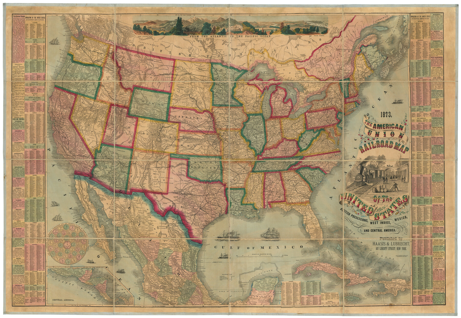
The American Union Railroad Map of the United States, British Possessions, West Indies, Mexico, and Central America
-
Map/Doc
97124
-
Collection
General Map Collection
-
Object Dates
1873 (Creation Date)
-
People and Organizations
Haasis & Lubrecht (Publisher)
-
Subjects
United States Railroads
-
Height x Width
40.2 x 58.2 inches
102.1 x 147.8 cm
Part of: General Map Collection
Castro County Rolled Sketch 12

Print $20.00
- Digital $50.00
Castro County Rolled Sketch 12
1945
Size 25.7 x 15.8 inches
Map/Doc 5421
Roberts County Working Sketch 29

Print $20.00
- Digital $50.00
Roberts County Working Sketch 29
1983
Size 18.6 x 34.8 inches
Map/Doc 63555
Lipscomb County Rolled Sketch 4

Print $40.00
- Digital $50.00
Lipscomb County Rolled Sketch 4
Size 100.5 x 22.4 inches
Map/Doc 9450
Bandera County Working Sketch 17

Print $20.00
- Digital $50.00
Bandera County Working Sketch 17
1943
Size 21.2 x 27.5 inches
Map/Doc 67613
Harris County Sketch File 21

Print $4.00
- Digital $50.00
Harris County Sketch File 21
1862
Size 13.1 x 8.2 inches
Map/Doc 25373
Culberson County Working Sketch Graphic Index, Sheet B (Sketches 41 to Most Recent)

Print $40.00
- Digital $50.00
Culberson County Working Sketch Graphic Index, Sheet B (Sketches 41 to Most Recent)
1943
Size 52.5 x 32.5 inches
Map/Doc 76515
DeWitt County Boundary File 3

Print $17.00
- Digital $50.00
DeWitt County Boundary File 3
Size 12.7 x 8.3 inches
Map/Doc 52514
Presidio County Sketch File 65

Print $6.00
- Digital $50.00
Presidio County Sketch File 65
1940
Size 11.0 x 15.3 inches
Map/Doc 34654
La Salle County Sketch File 19

Print $32.00
- Digital $50.00
La Salle County Sketch File 19
1885
Size 14.2 x 8.7 inches
Map/Doc 29509
Medina County Working Sketch 16

Print $20.00
- Digital $50.00
Medina County Working Sketch 16
1979
Size 27.1 x 28.2 inches
Map/Doc 70931
Shelby County Sketch File 3

Print $4.00
- Digital $50.00
Shelby County Sketch File 3
1849
Size 11.9 x 7.9 inches
Map/Doc 36595
Brazoria County Rolled Sketch 49

Print $20.00
- Digital $50.00
Brazoria County Rolled Sketch 49
1948
Size 24.1 x 36.5 inches
Map/Doc 5186
You may also like
Fort Bend County Rolled Sketch P

Print $20.00
- Digital $50.00
Fort Bend County Rolled Sketch P
Size 32.2 x 15.5 inches
Map/Doc 5906

Hall County Sketch File 32

Print $14.00
- Digital $50.00
Hall County Sketch File 32
1911
Size 11.2 x 8.8 inches
Map/Doc 24839
Flight Mission No. CUG-3P, Frame 37, Kleberg County

Print $20.00
- Digital $50.00
Flight Mission No. CUG-3P, Frame 37, Kleberg County
1956
Size 18.5 x 22.2 inches
Map/Doc 86242
Webb County Sketch File 4-1

Print $6.00
- Digital $50.00
Webb County Sketch File 4-1
1874
Size 10.3 x 8.2 inches
Map/Doc 39722
McMullen County

Print $40.00
- Digital $50.00
McMullen County
1918
Size 49.5 x 35.9 inches
Map/Doc 10788
The Judicial District/County of Ward. Created, January 19, 1841

Print $20.00
The Judicial District/County of Ward. Created, January 19, 1841
2020
Size 18.7 x 21.7 inches
Map/Doc 96354
Flight Mission No. CLL-3N, Frame 5, Willacy County

Print $20.00
- Digital $50.00
Flight Mission No. CLL-3N, Frame 5, Willacy County
1954
Size 18.4 x 22.1 inches
Map/Doc 87071

Flight Mission No. BQR-4K, Frame 66, Brazoria County

Print $20.00
- Digital $50.00
Flight Mission No. BQR-4K, Frame 66, Brazoria County
1952
Size 18.8 x 22.5 inches
Map/Doc 83999
Map of Donley County

Print $20.00
- Digital $50.00
Map of Donley County
1894
Size 44.6 x 35.8 inches
Map/Doc 16823
Terrell County Working Sketch 33

Print $20.00
- Digital $50.00
Terrell County Working Sketch 33
1945
Size 16.1 x 31.6 inches
Map/Doc 62125