Western United States

Print $20.00
- Digital $50.00
Western United States
1849
Size: 18.8 x 27.8 inches
2088
Soil Map - Ohio-Michigan, Toledo Set

Print $20.00
- Digital $50.00
Soil Map - Ohio-Michigan, Toledo Set
1902
Size: 21.4 x 30.5 inches
3023
Triangulation Net of the United States

Print $20.00
- Digital $50.00
Triangulation Net of the United States
1938
Size: 28.1 x 42.2 inches
3117
Hammond's continental map of the United States

Digital $50.00
Hammond's continental map of the United States
1940
Size: 33.2 x 50.2 inches
3118
National Map Company's New Road Survey of the United States Showing Main Highways

Digital $50.00
National Map Company's New Road Survey of the United States Showing Main Highways
Size: 44.5 x 38.2 inches
4659
National Map Company's New Road Survey of the United States Showing Main Highways

Print $20.00
- Digital $50.00
National Map Company's New Road Survey of the United States Showing Main Highways
Size: 44.3 x 38.2 inches
4674
United States including territories and insular possessions showing the extent of public surveys, national parks, national forests, indian reservations, national wildlife refuges, and reclamation projects

Print $40.00
- Digital $50.00
United States including territories and insular possessions showing the extent of public surveys, national parks, national forests, indian reservations, national wildlife refuges, and reclamation projects
1953
Size: 64.5 x 44.5 inches
65795
United States including territories and insular possessions showing the extent of public surveys, national parks, national forests, indian reservations, national wildlife refuges, and reclamation projects

Print $40.00
- Digital $50.00
United States including territories and insular possessions showing the extent of public surveys, national parks, national forests, indian reservations, national wildlife refuges, and reclamation projects
1953
Size: 64.3 x 44.5 inches
65796
Lines of Equal Magnetic Declination and of Equal Annual Change in the United States for 1930

Print $20.00
- Digital $50.00
Lines of Equal Magnetic Declination and of Equal Annual Change in the United States for 1930
1930
Size: 23.5 x 29.7 inches
69652
United States Base Map

Print $20.00
- Digital $50.00
United States Base Map
1916
Size: 19.2 x 29.5 inches
69653
The United States of America

Print $20.00
- Digital $50.00
The United States of America
1866
Size: 22.4 x 18.2 inches
72645
The United States of America

Print $20.00
- Digital $50.00
The United States of America
1866
Size: 21.3 x 18.3 inches
72646
Chart showing the relative positions of the lights in the Eighth Light House District extending from Cedar Keys, Florida to Rio Grande, Texas

Print $20.00
- Digital $50.00
Chart showing the relative positions of the lights in the Eighth Light House District extending from Cedar Keys, Florida to Rio Grande, Texas
1876
Size: 24.6 x 18.3 inches
72679
Chart showing the relative positions of the lights in the Eighth Light House District extending from Cedar Keys, Florida to Rio Grande, Texas

Print $20.00
- Digital $50.00
Chart showing the relative positions of the lights in the Eighth Light House District extending from Cedar Keys, Florida to Rio Grande, Texas
1876
Size: 24.7 x 18.2 inches
72680
Chart showing the positions of the lights in the Eighth L. H. District extending from the Perdido River, Florida to the Rio Grande, Texas

Print $20.00
- Digital $50.00
Chart showing the positions of the lights in the Eighth L. H. District extending from the Perdido River, Florida to the Rio Grande, Texas
1876
Size: 24.7 x 18.2 inches
72682
Map of Texas and the countries adjacent compiled in the Bureau of the Corps of Topographical Engineers from the best authorities for the State Department

Print $20.00
- Digital $50.00
Map of Texas and the countries adjacent compiled in the Bureau of the Corps of Topographical Engineers from the best authorities for the State Department
1844
Size: 25.9 x 18.2 inches
72714
Lighthouse establishment on the Atlantic and Gulf Coasts and coast signal stations

Print $20.00
- Digital $50.00
Lighthouse establishment on the Atlantic and Gulf Coasts and coast signal stations
1898
Size: 25.1 x 18.3 inches
73051
Isogonic Chart for 1950, United States. Including Isoporic Lines

Print $20.00
- Digital $50.00
Isogonic Chart for 1950, United States. Including Isoporic Lines
1950
Size: 32.2 x 47.2 inches
75921
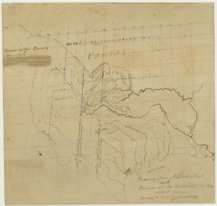
Tracing From [Melish's] Map with Kansas and the Panhandle of Texas plotted thereon Showing the disputed Territory
Print $20.00
Tracing From [Melish's] Map with Kansas and the Panhandle of Texas plotted thereon Showing the disputed Territory
1818
Size: 18.8 x 19.8 inches
76190
Phelps and Watson's Historical and Military Map of the Border and Southern States

Print $20.00
Phelps and Watson's Historical and Military Map of the Border and Southern States
1863
Size: 25.5 x 36.3 inches
76202
The Texas New Yorker's Map of the U. S. Accompanying the Map of Texas

Print $20.00
The Texas New Yorker's Map of the U. S. Accompanying the Map of Texas
1874
Size: 32.3 x 22.8 inches
76211
Stanford's Map of the Seat of War in America

Print $40.00
Stanford's Map of the Seat of War in America
1861
Size: 52.2 x 45.7 inches
76231
Map of the United States to accompany Granger's Southern and Western Texas Guide

Print $20.00
Map of the United States to accompany Granger's Southern and Western Texas Guide
1878
Size: 26.4 x 20.4 inches
76236
United States Including California, Texas, and c.

Print $20.00
United States Including California, Texas, and c.
1861
Size: 21.4 x 25.7 inches
76238
A Chart of the Internal Part of Louisiana

Print $20.00
A Chart of the Internal Part of Louisiana
1807
Size: 19.2 x 16.5 inches
79310
Mitchell's Travellers Guide Through the United States. A Map of the Roads, Distances, Steam Boat, and Canal Routes etc.

Print $20.00
Mitchell's Travellers Guide Through the United States. A Map of the Roads, Distances, Steam Boat, and Canal Routes etc.
1834
Size: 18.2 x 22.6 inches
79314
A New Map of the United States of America

Print $20.00
A New Map of the United States of America
1856
Size: 17.8 x 28.0 inches
79320
Correct Map of the Railway and Steamship Lines operated by the Southern Pacific Company

Print $20.00
Correct Map of the Railway and Steamship Lines operated by the Southern Pacific Company
1894
Size: 17.1 x 40.1 inches
79322
Correct Map of the Railway and Steamship Lines operated by the Southern Pacific Company

Print $20.00
Correct Map of the Railway and Steamship Lines operated by the Southern Pacific Company
1894
Size: 17.0 x 40.1 inches
79333
Western United States
Print $20.00
- Digital $50.00
Western United States
1849
-
Size
18.8 x 27.8 inches
-
Map/Doc
2088
-
Creation Date
1849
Soil Map - Ohio-Michigan, Toledo Set
Print $20.00
- Digital $50.00
Soil Map - Ohio-Michigan, Toledo Set
1902
-
Size
21.4 x 30.5 inches
-
Map/Doc
3023
-
Creation Date
1902
Triangulation Net of the United States
Print $20.00
- Digital $50.00
Triangulation Net of the United States
1938
-
Size
28.1 x 42.2 inches
-
Map/Doc
3117
-
Creation Date
1938
Hammond's continental map of the United States
Digital $50.00
Hammond's continental map of the United States
1940
-
Size
33.2 x 50.2 inches
-
Map/Doc
3118
-
Creation Date
1940
National Map Company's New Road Survey of the United States Showing Main Highways
Digital $50.00
National Map Company's New Road Survey of the United States Showing Main Highways
-
Size
44.5 x 38.2 inches
-
Map/Doc
4659
National Map Company's New Road Survey of the United States Showing Main Highways
Print $20.00
- Digital $50.00
National Map Company's New Road Survey of the United States Showing Main Highways
-
Size
44.3 x 38.2 inches
-
Map/Doc
4674
United States including territories and insular possessions showing the extent of public surveys, national parks, national forests, indian reservations, national wildlife refuges, and reclamation projects
Print $40.00
- Digital $50.00
United States including territories and insular possessions showing the extent of public surveys, national parks, national forests, indian reservations, national wildlife refuges, and reclamation projects
1953
-
Size
64.5 x 44.5 inches
-
Map/Doc
65795
-
Creation Date
1953
United States including territories and insular possessions showing the extent of public surveys, national parks, national forests, indian reservations, national wildlife refuges, and reclamation projects
Print $40.00
- Digital $50.00
United States including territories and insular possessions showing the extent of public surveys, national parks, national forests, indian reservations, national wildlife refuges, and reclamation projects
1953
-
Size
64.3 x 44.5 inches
-
Map/Doc
65796
-
Creation Date
1953
Lines of Equal Magnetic Declination and of Equal Annual Change in the United States for 1930
Print $20.00
- Digital $50.00
Lines of Equal Magnetic Declination and of Equal Annual Change in the United States for 1930
1930
-
Size
23.5 x 29.7 inches
-
Map/Doc
69652
-
Creation Date
1930
United States Base Map
Print $20.00
- Digital $50.00
United States Base Map
1916
-
Size
19.2 x 29.5 inches
-
Map/Doc
69653
-
Creation Date
1916
The United States of America
Print $20.00
- Digital $50.00
The United States of America
1866
-
Size
22.4 x 18.2 inches
-
Map/Doc
72645
-
Creation Date
1866
The United States of America
Print $20.00
- Digital $50.00
The United States of America
1866
-
Size
21.3 x 18.3 inches
-
Map/Doc
72646
-
Creation Date
1866
Chart showing the relative positions of the lights in the Eighth Light House District extending from Cedar Keys, Florida to Rio Grande, Texas
Print $20.00
- Digital $50.00
Chart showing the relative positions of the lights in the Eighth Light House District extending from Cedar Keys, Florida to Rio Grande, Texas
1876
-
Size
24.6 x 18.3 inches
-
Map/Doc
72679
-
Creation Date
1876
Chart showing the relative positions of the lights in the Eighth Light House District extending from Cedar Keys, Florida to Rio Grande, Texas
Print $20.00
- Digital $50.00
Chart showing the relative positions of the lights in the Eighth Light House District extending from Cedar Keys, Florida to Rio Grande, Texas
1876
-
Size
24.7 x 18.2 inches
-
Map/Doc
72680
-
Creation Date
1876
Chart showing the positions of the lights in the Eighth L. H. District extending from the Perdido River, Florida to the Rio Grande, Texas
Print $20.00
- Digital $50.00
Chart showing the positions of the lights in the Eighth L. H. District extending from the Perdido River, Florida to the Rio Grande, Texas
1876
-
Size
24.7 x 18.2 inches
-
Map/Doc
72682
-
Creation Date
1876
Map of Texas and the countries adjacent compiled in the Bureau of the Corps of Topographical Engineers from the best authorities for the State Department
Print $20.00
- Digital $50.00
Map of Texas and the countries adjacent compiled in the Bureau of the Corps of Topographical Engineers from the best authorities for the State Department
1844
-
Size
25.9 x 18.2 inches
-
Map/Doc
72714
-
Creation Date
1844
Lighthouse establishment on the Atlantic and Gulf Coasts and coast signal stations
Print $20.00
- Digital $50.00
Lighthouse establishment on the Atlantic and Gulf Coasts and coast signal stations
1898
-
Size
25.1 x 18.3 inches
-
Map/Doc
73051
-
Creation Date
1898
Isogonic Chart for 1950, United States. Including Isoporic Lines
Print $20.00
- Digital $50.00
Isogonic Chart for 1950, United States. Including Isoporic Lines
1950
-
Size
32.2 x 47.2 inches
-
Map/Doc
75921
-
Creation Date
1950
United States

Print $40.00
- Digital $50.00
United States
1961
-
Size
55.0 x 81.2 inches
-
Map/Doc
75922
-
Creation Date
1961
Tracing From [Melish's] Map with Kansas and the Panhandle of Texas plotted thereon Showing the disputed Territory
Print $20.00
Tracing From [Melish's] Map with Kansas and the Panhandle of Texas plotted thereon Showing the disputed Territory
1818
-
Size
18.8 x 19.8 inches
-
Map/Doc
76190
-
Creation Date
1818
Phelps and Watson's Historical and Military Map of the Border and Southern States
Print $20.00
Phelps and Watson's Historical and Military Map of the Border and Southern States
1863
-
Size
25.5 x 36.3 inches
-
Map/Doc
76202
-
Creation Date
1863
The Texas New Yorker's Map of the U. S. Accompanying the Map of Texas
Print $20.00
The Texas New Yorker's Map of the U. S. Accompanying the Map of Texas
1874
-
Size
32.3 x 22.8 inches
-
Map/Doc
76211
-
Creation Date
1874
Stanford's Map of the Seat of War in America
Print $40.00
Stanford's Map of the Seat of War in America
1861
-
Size
52.2 x 45.7 inches
-
Map/Doc
76231
-
Creation Date
1861
Map of the United States to accompany Granger's Southern and Western Texas Guide
Print $20.00
Map of the United States to accompany Granger's Southern and Western Texas Guide
1878
-
Size
26.4 x 20.4 inches
-
Map/Doc
76236
-
Creation Date
1878
United States Including California, Texas, and c.
Print $20.00
United States Including California, Texas, and c.
1861
-
Size
21.4 x 25.7 inches
-
Map/Doc
76238
-
Creation Date
1861
A Chart of the Internal Part of Louisiana
Print $20.00
A Chart of the Internal Part of Louisiana
1807
-
Size
19.2 x 16.5 inches
-
Map/Doc
79310
-
Creation Date
1807
Mitchell's Travellers Guide Through the United States. A Map of the Roads, Distances, Steam Boat, and Canal Routes etc.
Print $20.00
Mitchell's Travellers Guide Through the United States. A Map of the Roads, Distances, Steam Boat, and Canal Routes etc.
1834
-
Size
18.2 x 22.6 inches
-
Map/Doc
79314
-
Creation Date
1834
A New Map of the United States of America
Print $20.00
A New Map of the United States of America
1856
-
Size
17.8 x 28.0 inches
-
Map/Doc
79320
-
Creation Date
1856
Correct Map of the Railway and Steamship Lines operated by the Southern Pacific Company
Print $20.00
Correct Map of the Railway and Steamship Lines operated by the Southern Pacific Company
1894
-
Size
17.1 x 40.1 inches
-
Map/Doc
79322
-
Creation Date
1894
Correct Map of the Railway and Steamship Lines operated by the Southern Pacific Company
Print $20.00
Correct Map of the Railway and Steamship Lines operated by the Southern Pacific Company
1894
-
Size
17.0 x 40.1 inches
-
Map/Doc
79333
-
Creation Date
1894