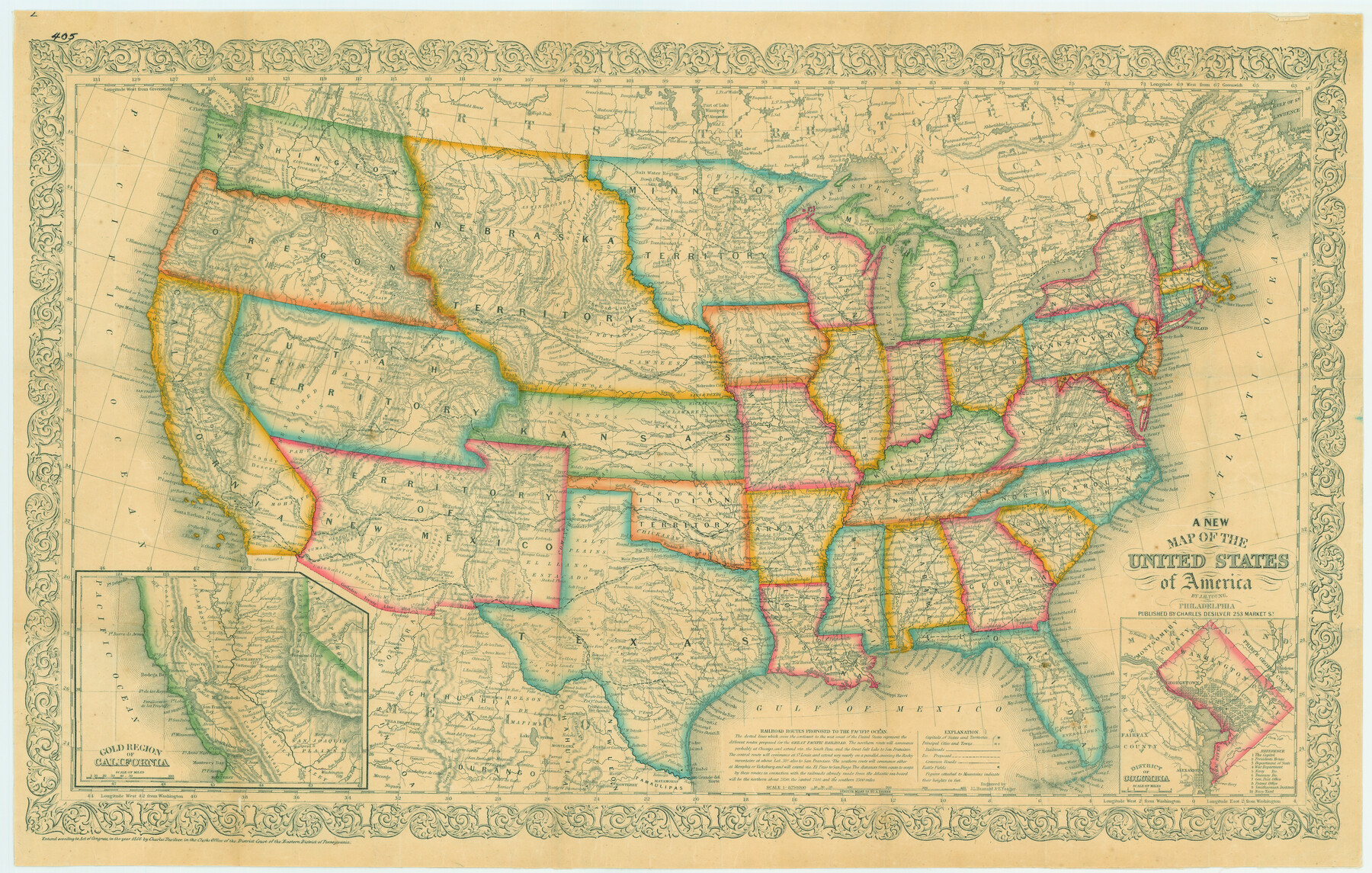
A New Map of the United States of America
-
Map/Doc
79320
-
Collection
Texas State Library and Archives
-
Object Dates
1856 (Creation Date)
-
People and Organizations
Charles De Silver (Publisher)
J.H. Young (Draftsman)
-
Subjects
United States
-
Height x Width
17.8 x 28.0 inches
45.2 x 71.1 cm
-
Comments
Prints available courtesy of the Texas State Library and Archives.
More info can be found here: TSLAC Map 00405
Part of: Texas State Library and Archives
General Highway Map. Detail of Cities and Towns in Falls County, Texas

Print $20.00
General Highway Map. Detail of Cities and Towns in Falls County, Texas
1961
Size 18.1 x 24.4 inches
Map/Doc 79463
General Highway Map, El Paso County, Texas

Print $20.00
General Highway Map, El Paso County, Texas
1961
Size 18.1 x 24.7 inches
Map/Doc 79457
General Highway Map, Hill County, Texas

Print $20.00
General Highway Map, Hill County, Texas
1940
Size 25.0 x 18.6 inches
Map/Doc 79129
General Highway Map, Tarrant County, Texas

Print $20.00
General Highway Map, Tarrant County, Texas
1961
Size 18.3 x 25.1 inches
Map/Doc 79664
General Highway Map, Upshur County, Gregg County, Texas

Print $20.00
General Highway Map, Upshur County, Gregg County, Texas
1939
Size 24.9 x 18.6 inches
Map/Doc 79105
General Highway Map. Detail of Cities and Towns in Wharton County, Texas [El Campo and Wharton]
![79275, General Highway Map. Detail of Cities and Towns in Wharton County, Texas [El Campo and Wharton], Texas State Library and Archives](https://historictexasmaps.com/wmedia_w700/maps/79275.tif.jpg)
Print $20.00
General Highway Map. Detail of Cities and Towns in Wharton County, Texas [El Campo and Wharton]
1940
Size 18.4 x 24.8 inches
Map/Doc 79275
General Highway Map, Liberty County, Texas

Print $20.00
General Highway Map, Liberty County, Texas
1961
Size 18.2 x 24.7 inches
Map/Doc 79570
General Highway Map, Cass County, Texas

Print $20.00
General Highway Map, Cass County, Texas
1961
Size 18.3 x 24.7 inches
Map/Doc 79402
General Highway Map, Austin County, Texas

Print $20.00
General Highway Map, Austin County, Texas
1939
Size 18.4 x 25.0 inches
Map/Doc 79009
General Highway Map, Eastland County, Texas

Print $20.00
General Highway Map, Eastland County, Texas
1961
Size 18.2 x 24.7 inches
Map/Doc 79450
General Highway Map. Detail of Cities and Towns in Travis County, Texas. City Map, Austin and vicinity, Travis County, Texas

Print $20.00
General Highway Map. Detail of Cities and Towns in Travis County, Texas. City Map, Austin and vicinity, Travis County, Texas
1961
Size 18.2 x 25.0 inches
Map/Doc 79685
General Highway Map, Reeves County, Texas

Print $20.00
General Highway Map, Reeves County, Texas
1940
Size 24.8 x 18.2 inches
Map/Doc 79227
You may also like
United States - Gulf Coast - Padre I. and Laguna Madre Lat. 27° 12' to Lat. 26° 33' Texas

Print $20.00
- Digital $50.00
United States - Gulf Coast - Padre I. and Laguna Madre Lat. 27° 12' to Lat. 26° 33' Texas
1913
Size 26.8 x 18.2 inches
Map/Doc 72815
Howard County Rolled Sketch 11

Print $20.00
- Digital $50.00
Howard County Rolled Sketch 11
1940
Size 21.4 x 30.1 inches
Map/Doc 6242

Bell County Sketch File 19

Print $4.00
- Digital $50.00
Bell County Sketch File 19
Size 7.6 x 7.7 inches
Map/Doc 14402
Liberty County Working Sketch 69

Print $20.00
- Digital $50.00
Liberty County Working Sketch 69
1972
Size 29.8 x 41.8 inches
Map/Doc 70529
Sutton County Working Sketch 35

Print $20.00
- Digital $50.00
Sutton County Working Sketch 35
1939
Size 35.0 x 14.3 inches
Map/Doc 62378
Presidio County Sketch File 74

Print $8.00
- Digital $50.00
Presidio County Sketch File 74
1946
Size 11.4 x 8.8 inches
Map/Doc 34687
Flight Mission No. BQY-4M, Frame 55, Harris County

Print $20.00
- Digital $50.00
Flight Mission No. BQY-4M, Frame 55, Harris County
1953
Size 18.5 x 22.3 inches
Map/Doc 85264

Throckmorton County Working Sketch 2

Print $20.00
- Digital $50.00
Throckmorton County Working Sketch 2
1919
Size 20.9 x 16.9 inches
Map/Doc 62111

Working Sketch in Moore County

Print $3.00
- Digital $50.00
Working Sketch in Moore County
1910
Size 15.0 x 10.0 inches
Map/Doc 91537