Yellow Fever Deaths in the United States

Yellow Fever Deaths in the United States
2022
Size: 8.5 x 11.0 inches
97093
Westliches - Nordamerica

Print $20.00
- Digital $50.00
Westliches - Nordamerica
1867
Size: 25.3 x 20.7 inches
93753
Western United States

Print $20.00
- Digital $50.00
Western United States
1849
Size: 18.8 x 27.8 inches
2088
Western Territories of the United States

Print $20.00
- Digital $50.00
Western Territories of the United States
1847
Size: 12.1 x 19.0 inches
93543
W. Alvin Lloyd's Southern Rail-Road Map

Print $20.00
- Digital $50.00
W. Alvin Lloyd's Southern Rail-Road Map
1863
Size: 18.4 x 23.7 inches
97496
Vereinigte Staaten von Nord America

Print $20.00
- Digital $50.00
Vereinigte Staaten von Nord America
1828
Size: 17.6 x 21.9 inches
93644
United States of North America (Eastern and Central)

Print $20.00
- Digital $50.00
United States of North America (Eastern and Central)
1862
Size: 19.3 x 26.2 inches
93667
United States of America, compiled from the latest & best authorities by John Melish, 1820

Print $20.00
- Digital $50.00
United States of America, compiled from the latest & best authorities by John Melish, 1820
1820
Size: 16.7 x 20.2 inches
89220
United States of America corrected & improved from the best authorities

Print $20.00
- Digital $50.00
United States of America corrected & improved from the best authorities
1820
Size: 17.5 x 26.3 inches
93953
United States of America compiled from the latest & best Authorities

Print $20.00
- Digital $50.00
United States of America compiled from the latest & best Authorities
1818
Size: 17.3 x 20.9 inches
97135
United States including territories and insular possessions showing the extent of public surveys, national parks, national forests, indian reservations, national wildlife refuges, and reclamation projects

Print $40.00
- Digital $50.00
United States including territories and insular possessions showing the extent of public surveys, national parks, national forests, indian reservations, national wildlife refuges, and reclamation projects
1953
Size: 64.5 x 44.5 inches
65795
United States including territories and insular possessions showing the extent of public surveys, national parks, national forests, indian reservations, national wildlife refuges, and reclamation projects

Print $40.00
- Digital $50.00
United States including territories and insular possessions showing the extent of public surveys, national parks, national forests, indian reservations, national wildlife refuges, and reclamation projects
1953
Size: 64.3 x 44.5 inches
65796
United States and Territories, showing the extent of Public Surveys, Indian and Forest Reservations, Rail Roads, Canals and other detail, compiled from official surveys of the General Land Office and other authentic sources

Print $40.00
- Digital $50.00
United States and Territories, showing the extent of Public Surveys, Indian and Forest Reservations, Rail Roads, Canals and other detail, compiled from official surveys of the General Land Office and other authentic sources
1897
Size: 59.5 x 85.8 inches
93969
United States and Additions, 1820

Print $20.00
- Digital $50.00
United States and Additions, 1820
1820
Size: 21.8 x 27.0 inches
93798
United States Population Distribution by County and Territory, per the U.S. Census of 1900

United States Population Distribution by County and Territory, per the U.S. Census of 1900
2025
Size: 8.5 x 11.0 inches
97481
United States Population Distribution by County and Territory, per the U.S. Census of 1890

United States Population Distribution by County and Territory, per the U.S. Census of 1890
2025
Size: 8.5 x 11.0 inches
97480
United States Population Distribution by County and Territory, per the U.S. Census of 1880

United States Population Distribution by County and Territory, per the U.S. Census of 1880
2024
Size: 8.5 x 11.0 inches
97284
United States Population Distribution by County and Territory, per the U.S. Census of 1870

United States Population Distribution by County and Territory, per the U.S. Census of 1870
2025
Size: 8.5 x 11.0 inches
97479
United States Mileage Chart / United States Mileage Table / Hawaii / Alaska

United States Mileage Chart / United States Mileage Table / Hawaii / Alaska
Size: 26.5 x 38.1 inches
96820
United States Including California, Texas, and c.

Print $20.00
United States Including California, Texas, and c.
1861
Size: 21.4 x 25.7 inches
76238
United States Base Map

Print $20.00
- Digital $50.00
United States Base Map
1916
Size: 19.2 x 29.5 inches
69653


Triangulation Net of the United States

Print $20.00
- Digital $50.00
Triangulation Net of the United States
1938
Size: 28.1 x 42.2 inches
3117
Tracing From [Melish's] Map with Kansas and the Panhandle of Texas plotted thereon Showing the disputed Territory
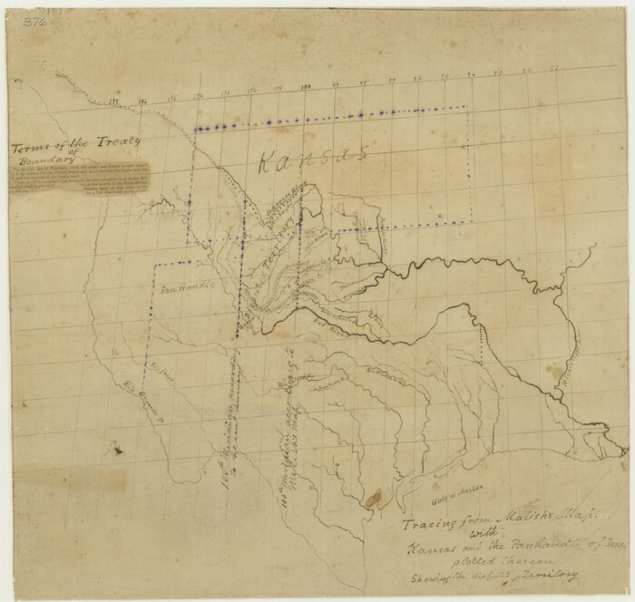
Print $20.00
Tracing From [Melish's] Map with Kansas and the Panhandle of Texas plotted thereon Showing the disputed Territory
1818
Size: 18.8 x 19.8 inches
76190
The great railroad routes to the Pacific, and their connections

Print $20.00
- Digital $50.00
The great railroad routes to the Pacific, and their connections
1869
Size: 16.3 x 29.4 inches
96974
[United States]
![97197, [United States], General Map Collection](https://historictexasmaps.com/wmedia_w700/maps/97197.tif.jpg)
Print $20.00
- Digital $50.00
[United States]
1848
-
Size
17.7 x 37.4 inches
-
Map/Doc
97197
-
Creation Date
1848
Yellow Fever Deaths in the United States
Yellow Fever Deaths in the United States
2022
-
Size
8.5 x 11.0 inches
-
Map/Doc
97093
-
Creation Date
2022
Westliches - Nordamerica
Print $20.00
- Digital $50.00
Westliches - Nordamerica
1867
-
Size
25.3 x 20.7 inches
-
Map/Doc
93753
-
Creation Date
1867
Western United States
Print $20.00
- Digital $50.00
Western United States
1849
-
Size
18.8 x 27.8 inches
-
Map/Doc
2088
-
Creation Date
1849
Western Territories of the United States
Print $20.00
- Digital $50.00
Western Territories of the United States
1847
-
Size
12.1 x 19.0 inches
-
Map/Doc
93543
-
Creation Date
1847
W. Alvin Lloyd's Southern Rail-Road Map
Print $20.00
- Digital $50.00
W. Alvin Lloyd's Southern Rail-Road Map
1863
-
Size
18.4 x 23.7 inches
-
Map/Doc
97496
-
Creation Date
1863
Vereinigte Staaten von Nord America
Print $20.00
- Digital $50.00
Vereinigte Staaten von Nord America
1828
-
Size
17.6 x 21.9 inches
-
Map/Doc
93644
-
Creation Date
1828
United States of North America (Eastern and Central)
Print $20.00
- Digital $50.00
United States of North America (Eastern and Central)
1862
-
Size
19.3 x 26.2 inches
-
Map/Doc
93667
-
Creation Date
1862
United States of America, compiled from the latest & best authorities by John Melish, 1820
Print $20.00
- Digital $50.00
United States of America, compiled from the latest & best authorities by John Melish, 1820
1820
-
Size
16.7 x 20.2 inches
-
Map/Doc
89220
-
Creation Date
1820
United States of America corrected & improved from the best authorities
Print $20.00
- Digital $50.00
United States of America corrected & improved from the best authorities
1820
-
Size
17.5 x 26.3 inches
-
Map/Doc
93953
-
Creation Date
1820
United States of America compiled from the latest & best Authorities
Print $20.00
- Digital $50.00
United States of America compiled from the latest & best Authorities
1818
-
Size
17.3 x 20.9 inches
-
Map/Doc
97135
-
Creation Date
1818
United States including territories and insular possessions showing the extent of public surveys, national parks, national forests, indian reservations, national wildlife refuges, and reclamation projects
Print $40.00
- Digital $50.00
United States including territories and insular possessions showing the extent of public surveys, national parks, national forests, indian reservations, national wildlife refuges, and reclamation projects
1953
-
Size
64.5 x 44.5 inches
-
Map/Doc
65795
-
Creation Date
1953
United States including territories and insular possessions showing the extent of public surveys, national parks, national forests, indian reservations, national wildlife refuges, and reclamation projects
Print $40.00
- Digital $50.00
United States including territories and insular possessions showing the extent of public surveys, national parks, national forests, indian reservations, national wildlife refuges, and reclamation projects
1953
-
Size
64.3 x 44.5 inches
-
Map/Doc
65796
-
Creation Date
1953
United States and Territories, showing the extent of Public Surveys, Indian and Forest Reservations, Rail Roads, Canals and other detail, compiled from official surveys of the General Land Office and other authentic sources
Print $40.00
- Digital $50.00
United States and Territories, showing the extent of Public Surveys, Indian and Forest Reservations, Rail Roads, Canals and other detail, compiled from official surveys of the General Land Office and other authentic sources
1897
-
Size
59.5 x 85.8 inches
-
Map/Doc
93969
-
Creation Date
1897
United States and Additions, 1820
Print $20.00
- Digital $50.00
United States and Additions, 1820
1820
-
Size
21.8 x 27.0 inches
-
Map/Doc
93798
-
Creation Date
1820
United States Population Distribution by County and Territory, per the U.S. Census of 1900
United States Population Distribution by County and Territory, per the U.S. Census of 1900
2025
-
Size
8.5 x 11.0 inches
-
Map/Doc
97481
-
Creation Date
2025
United States Population Distribution by County and Territory, per the U.S. Census of 1890
United States Population Distribution by County and Territory, per the U.S. Census of 1890
2025
-
Size
8.5 x 11.0 inches
-
Map/Doc
97480
-
Creation Date
2025
United States Population Distribution by County and Territory, per the U.S. Census of 1880
United States Population Distribution by County and Territory, per the U.S. Census of 1880
2024
-
Size
8.5 x 11.0 inches
-
Map/Doc
97284
-
Creation Date
2024
United States Population Distribution by County and Territory, per the U.S. Census of 1870
United States Population Distribution by County and Territory, per the U.S. Census of 1870
2025
-
Size
8.5 x 11.0 inches
-
Map/Doc
97479
-
Creation Date
2025
United States Mileage Chart / United States Mileage Table / Hawaii / Alaska
United States Mileage Chart / United States Mileage Table / Hawaii / Alaska
-
Size
26.5 x 38.1 inches
-
Map/Doc
96820
United States Including California, Texas, and c.
Print $20.00
United States Including California, Texas, and c.
1861
-
Size
21.4 x 25.7 inches
-
Map/Doc
76238
-
Creation Date
1861
United States Base Map
Print $20.00
- Digital $50.00
United States Base Map
1916
-
Size
19.2 x 29.5 inches
-
Map/Doc
69653
-
Creation Date
1916
United States

Print $40.00
- Digital $50.00
United States
1961
-
Size
55.0 x 81.2 inches
-
Map/Doc
75922
-
Creation Date
1961
United States

Print $20.00
- Digital $50.00
United States
1851
-
Size
10.8 x 15.1 inches
-
Map/Doc
93799
-
Creation Date
1851
United States

Print $20.00
- Digital $50.00
United States
1838
-
Size
12.2 x 19.6 inches
-
Map/Doc
97099
-
Creation Date
1838
Triangulation Net of the United States
Print $20.00
- Digital $50.00
Triangulation Net of the United States
1938
-
Size
28.1 x 42.2 inches
-
Map/Doc
3117
-
Creation Date
1938
Tracing From [Melish's] Map with Kansas and the Panhandle of Texas plotted thereon Showing the disputed Territory
Print $20.00
Tracing From [Melish's] Map with Kansas and the Panhandle of Texas plotted thereon Showing the disputed Territory
1818
-
Size
18.8 x 19.8 inches
-
Map/Doc
76190
-
Creation Date
1818
The great railroad routes to the Pacific, and their connections
Print $20.00
- Digital $50.00
The great railroad routes to the Pacific, and their connections
1869
-
Size
16.3 x 29.4 inches
-
Map/Doc
96974
-
Creation Date
1869