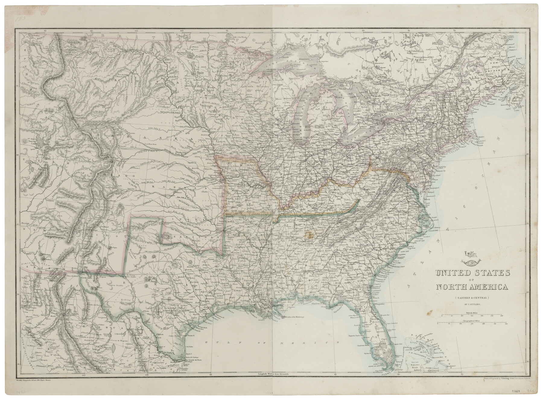
United States of North America (Eastern and Central)
-
Map/Doc
93667
-
Collection
General Map Collection
-
Object Dates
[1862 ca.] (Creation Date)
2014/3/10 (File Date)
-
People and Organizations
Weekly Dispatch Atlas (Publisher)
T. Ettling (Printer)
T. Ettling (Draftsman)
-
Subjects
United States
-
Height x Width
19.3 x 26.2 inches
49.0 x 66.6 cm
-
Comments
Conserved in 2014.
Part of: General Map Collection
Hunt County Sketch File 21

Print $4.00
- Digital $50.00
Hunt County Sketch File 21
Size 8.1 x 5.8 inches
Map/Doc 27122
Newton County Working Sketch 7

Print $20.00
- Digital $50.00
Newton County Working Sketch 7
1936
Size 32.3 x 37.0 inches
Map/Doc 71253
Brooks County Rolled Sketch 17

Print $20.00
- Digital $50.00
Brooks County Rolled Sketch 17
1941
Size 30.8 x 36.5 inches
Map/Doc 8532
The Inca, Machu Picchu Salutes the Sun

The Inca, Machu Picchu Salutes the Sun
Size 20.4 x 31.3 inches
Map/Doc 95935
Cherokee County Sketch File 6

Print $22.00
- Digital $50.00
Cherokee County Sketch File 6
1852
Size 12.4 x 16.4 inches
Map/Doc 18126
Matagorda County Working Sketch 32

Print $20.00
- Digital $50.00
Matagorda County Working Sketch 32
1993
Size 28.4 x 33.5 inches
Map/Doc 70890
Coke County Boundary File 2

Print $64.00
- Digital $50.00
Coke County Boundary File 2
Size 49.0 x 9.0 inches
Map/Doc 51580
Dimmit County Working Sketch 52

Print $20.00
- Digital $50.00
Dimmit County Working Sketch 52
1989
Size 25.2 x 37.0 inches
Map/Doc 68713
Map of Montague County

Print $20.00
- Digital $50.00
Map of Montague County
1868
Size 19.9 x 16.9 inches
Map/Doc 3888
Fort Bend County Boundary File 3

Print $2.00
- Digital $50.00
Fort Bend County Boundary File 3
Size 8.8 x 11.3 inches
Map/Doc 53566
Leon County Rolled Sketch 29

Print $20.00
- Digital $50.00
Leon County Rolled Sketch 29
1992
Size 34.6 x 32.9 inches
Map/Doc 6612
Eastland County

Print $20.00
- Digital $50.00
Eastland County
1945
Size 44.4 x 43.7 inches
Map/Doc 95486
You may also like
Aransas County Rolled Sketch 16

Print $40.00
- Digital $50.00
Aransas County Rolled Sketch 16
1965
Size 45.9 x 92.9 inches
Map/Doc 9005
Terrell County Working Sketch Graphic index - sheet B

Print $20.00
- Digital $50.00
Terrell County Working Sketch Graphic index - sheet B
1931
Size 47.7 x 39.6 inches
Map/Doc 76711

[West Half of the State of Kansas]
![93159, [West Half of the State of Kansas], Twichell Survey Records](https://historictexasmaps.com/wmedia_w700/maps/93159-1.tif.jpg)
Print $40.00
- Digital $50.00
[West Half of the State of Kansas]
Size 60.8 x 54.0 inches
Map/Doc 93159
Calhoun County Rolled Sketch 11

Print $3.00
- Digital $50.00
Calhoun County Rolled Sketch 11
1942
Size 10.9 x 16.2 inches
Map/Doc 5463
Kimble County Sketch File 3

Print $4.00
- Digital $50.00
Kimble County Sketch File 3
1847
Size 9.1 x 11.5 inches
Map/Doc 28910
Travis County

Print $40.00
- Digital $50.00
Travis County
1936
Size 46.9 x 54.1 inches
Map/Doc 95479
Chambers County NRC Article 33.136 Sketch 10

Print $44.00
- Digital $50.00
Chambers County NRC Article 33.136 Sketch 10
2014
Size 24.0 x 36.0 inches
Map/Doc 94498
Parker County Working Sketch 6

Print $20.00
- Digital $50.00
Parker County Working Sketch 6
1923
Map/Doc 71456
Hudspeth County Rolled Sketch 52

Print $20.00
- Digital $50.00
Hudspeth County Rolled Sketch 52
1975
Size 27.2 x 21.6 inches
Map/Doc 6257
Lampasas County Boundary File 8

Print $67.00
- Digital $50.00
Lampasas County Boundary File 8
Size 11.0 x 17.0 inches
Map/Doc 56158
Galveston County NRC Article 33.136 Sketch 55B

Print $24.00
- Digital $50.00
Galveston County NRC Article 33.136 Sketch 55B
2007
Size 24.0 x 36.0 inches
Map/Doc 94666