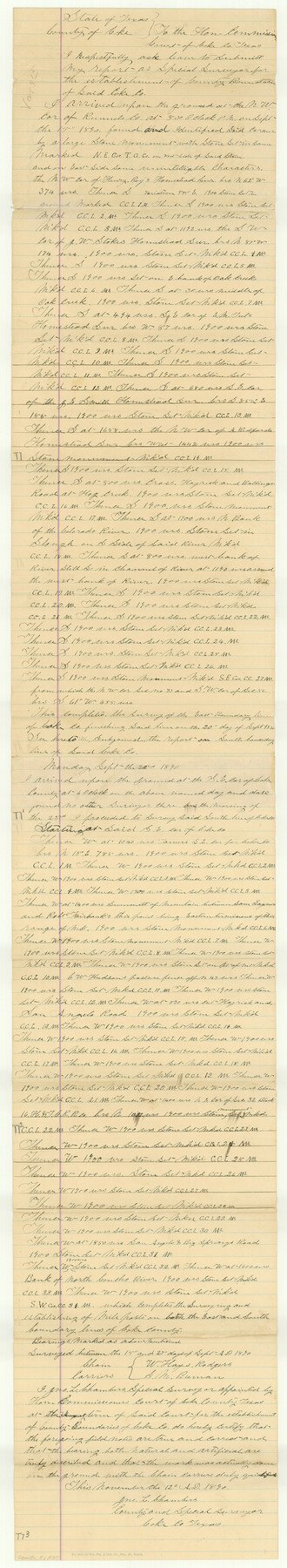
Coke County Boundary File 2
[Letter stating the Commissioner's Court's approval of East and South boundary line of Coke County]
-
Map/Doc
51580
-
Collection
General Map Collection
-
Counties
Coke
-
Subjects
County Boundaries
-
Height x Width
49.0 x 9.0 inches
124.5 x 22.9 cm
Part of: General Map Collection
Marion County Working Sketch 13

Print $20.00
- Digital $50.00
Marion County Working Sketch 13
1953
Size 33.2 x 36.3 inches
Map/Doc 70789

Goliad County Sketch File 11

Print $40.00
- Digital $50.00
Goliad County Sketch File 11
Size 13.4 x 12.5 inches
Map/Doc 24228
Jefferson County Aerial Photograph Index Sheet 1

Print $20.00
- Digital $50.00
Jefferson County Aerial Photograph Index Sheet 1
1953
Size 23.3 x 16.8 inches
Map/Doc 83707
Duval County Sketch File 71

Print $4.00
- Digital $50.00
Duval County Sketch File 71
1953
Size 15.2 x 9.0 inches
Map/Doc 21458
Reagan County Working Sketch 43

Print $20.00
- Digital $50.00
Reagan County Working Sketch 43
1984
Size 36.4 x 27.1 inches
Map/Doc 71885
South Part Brewster Co.

Print $40.00
- Digital $50.00
South Part Brewster Co.
Size 36.5 x 51.5 inches
Map/Doc 66723
Uvalde County Working Sketch 12

Print $20.00
- Digital $50.00
Uvalde County Working Sketch 12
1943
Size 28.5 x 27.4 inches
Map/Doc 72082
Polk County Sketch File 23A

Print $20.00
- Digital $50.00
Polk County Sketch File 23A
Size 23.4 x 24.3 inches
Map/Doc 12192
Harris County Boundary File 39 (15)

Print $8.00
- Digital $50.00
Harris County Boundary File 39 (15)
Size 7.2 x 8.3 inches
Map/Doc 54350
Flight Mission No. CUG-1P, Frame 113, Kleberg County

Print $20.00
- Digital $50.00
Flight Mission No. CUG-1P, Frame 113, Kleberg County
1956
Size 18.8 x 22.2 inches
Map/Doc 86163
Parker County Sketch File 27

Print $20.00
- Digital $50.00
Parker County Sketch File 27
1876
Size 23.7 x 23.8 inches
Map/Doc 12146
You may also like
Hays County Rolled Sketch 25

Print $20.00
- Digital $50.00
Hays County Rolled Sketch 25
1925
Size 17.5 x 40.0 inches
Map/Doc 6181

Uvalde County Rolled Sketch B

Print $20.00
- Digital $50.00
Uvalde County Rolled Sketch B
1847
Size 28.8 x 22.4 inches
Map/Doc 8105
Texas and Mexico showing Houston and Texas Central System of Railways

Print $20.00
- Digital $50.00
Texas and Mexico showing Houston and Texas Central System of Railways
1885
Size 29.0 x 21.6 inches
Map/Doc 94274
Young County Rolled Sketch 2

Print $20.00
- Digital $50.00
Young County Rolled Sketch 2
Size 26.2 x 25.0 inches
Map/Doc 8292
Hamilton County Sketch File 9

Print $6.00
- Digital $50.00
Hamilton County Sketch File 9
1874
Size 12.1 x 8.2 inches
Map/Doc 24916
Kendall County Sketch File 1

Print $4.00
- Digital $50.00
Kendall County Sketch File 1
Size 9.6 x 8.3 inches
Map/Doc 28671
[Surveys in Tyler County]
![352, [Surveys in Tyler County], General Map Collection](https://historictexasmaps.com/wmedia_w700/maps/352.tif.jpg)
Print $2.00
- Digital $50.00
[Surveys in Tyler County]
1847
Size 8.3 x 5.2 inches
Map/Doc 352
Flight Mission No. DAG-23K, Frame 172, Matagorda County

Print $20.00
- Digital $50.00
Flight Mission No. DAG-23K, Frame 172, Matagorda County
1953
Size 18.6 x 16.0 inches
Map/Doc 86510
Rusk County Sketch File 6

Print $4.00
Rusk County Sketch File 6
1848
Size 6.3 x 7.9 inches
Map/Doc 35499
Coleman County Working Sketch 4

Print $20.00
- Digital $50.00
Coleman County Working Sketch 4
1918
Size 22.7 x 23.6 inches
Map/Doc 68070
Current Miscellaneous File 56

Print $10.00
- Digital $50.00
Current Miscellaneous File 56
1954
Size 12.2 x 9.2 inches
Map/Doc 74045