Chambers County NRC Article 33.136 Sketch 10
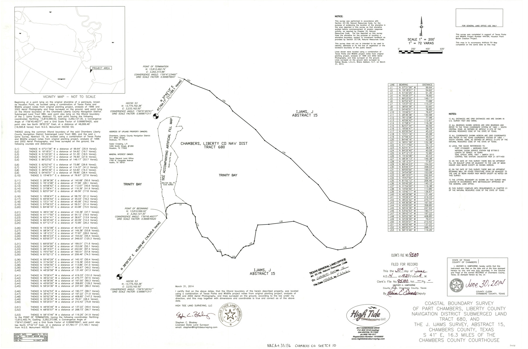
Coastal Boundary Survey of part Chambers, Liberty County Navigation District submerged land tract 680, and the J. Ijams survey, abstract 15, Chambers County , Texas
-
Map/Doc
94498
-
Collection
General Map Collection
-
Object Dates
2014/3/31 (Creation Date)
2018/4/20 (File Date)
-
People and Organizations
Stephen C. Blaskey (Surveyor/Engineer)
-
Counties
Chambers
-
Subjects
Surveying CBS
-
Height x Width
24.0 x 36.0 inches
61.0 x 91.4 cm
-
Medium
multi-page, multi-format
-
Comments
Project: Houston Ponit Marsh Creation Project No.: 444784 (TPWD)
Part of: General Map Collection
Flight Mission No. DQN-7K, Frame 36, Calhoun County

Print $20.00
- Digital $50.00
Flight Mission No. DQN-7K, Frame 36, Calhoun County
1953
Size 18.5 x 22.2 inches
Map/Doc 84474
The Spot Map of San Antonio including a classified directory showing location of postal zones, points of interest, places of business - and how to get there

Print $20.00
- Digital $50.00
The Spot Map of San Antonio including a classified directory showing location of postal zones, points of interest, places of business - and how to get there
1941
Size 21.2 x 28.2 inches
Map/Doc 95953

San Augustine County Sketch File 20

Print $82.00
- Digital $50.00
San Augustine County Sketch File 20
1951
Size 8.9 x 14.4 inches
Map/Doc 35680
Motley County Sketch File 2 (S)

Print $20.00
- Digital $50.00
Motley County Sketch File 2 (S)
Size 31.1 x 25.1 inches
Map/Doc 42133
Clay County Sketch File 38a

Print $6.00
- Digital $50.00
Clay County Sketch File 38a
1939
Size 14.3 x 8.8 inches
Map/Doc 18469
Goliad County Sketch File 23

Print $4.00
- Digital $50.00
Goliad County Sketch File 23
1877
Size 8.1 x 12.8 inches
Map/Doc 24295
Coleman County Working Sketch 12

Print $20.00
- Digital $50.00
Coleman County Working Sketch 12
1951
Size 25.7 x 26.2 inches
Map/Doc 68078
Val Verde County Working Sketch 116

Print $20.00
- Digital $50.00
Val Verde County Working Sketch 116
2003
Size 38.4 x 34.8 inches
Map/Doc 78493
Comal County Working Sketch 4

Print $20.00
- Digital $50.00
Comal County Working Sketch 4
1950
Size 38.3 x 24.3 inches
Map/Doc 68170
Flight Mission No. CRC-5R, Frame 26, Chambers County

Print $20.00
- Digital $50.00
Flight Mission No. CRC-5R, Frame 26, Chambers County
1956
Size 18.6 x 22.5 inches
Map/Doc 84948
Map of Texas Before Admission to the Union and Adjoining State with Northern Portions of the Mexican States of Coahulia & Chihuahua

Print $20.00
- Digital $50.00
Map of Texas Before Admission to the Union and Adjoining State with Northern Portions of the Mexican States of Coahulia & Chihuahua
1834
Size 18.8 x 21.2 inches
Map/Doc 2107
You may also like
Jasper County Working Sketch 25

Print $20.00
- Digital $50.00
Jasper County Working Sketch 25
1951
Size 21.6 x 32.3 inches
Map/Doc 66487
The Republic County of Montgomery. Created, December 14, 1837

Print $20.00
The Republic County of Montgomery. Created, December 14, 1837
2020
Size 19.9 x 21.7 inches
Map/Doc 96234
General Highway Map, Wichita County, Texas

Print $20.00
General Highway Map, Wichita County, Texas
1940
Size 18.1 x 24.8 inches
Map/Doc 79277
Dimmit County Sketch File 11a

Print $20.00
- Digital $50.00
Dimmit County Sketch File 11a
1880
Size 12.9 x 18.7 inches
Map/Doc 11339
Montgomery County Rolled Sketch 33

Print $40.00
- Digital $50.00
Montgomery County Rolled Sketch 33
1953
Size 48.1 x 39.6 inches
Map/Doc 9541
History of the Geography of Texas

Print $40.00
- Digital $50.00
History of the Geography of Texas
1897
Size 70.7 x 52.9 inches
Map/Doc 3095
Location of the Southern Kansas Railway of Texas

Print $40.00
- Digital $50.00
Location of the Southern Kansas Railway of Texas
1887
Size 19.0 x 103.2 inches
Map/Doc 64182
[H. & T. C. RR. Company, Block 47, Sections 20- 28]
![91249, [H. & T. C. RR. Company, Block 47, Sections 20- 28], Twichell Survey Records](https://historictexasmaps.com/wmedia_w700/maps/91249-1.tif.jpg)
Print $20.00
- Digital $50.00
[H. & T. C. RR. Company, Block 47, Sections 20- 28]
Size 16.1 x 13.7 inches
Map/Doc 91249
Map of Collingsworth County

Print $20.00
- Digital $50.00
Map of Collingsworth County
1899
Size 41.1 x 38.6 inches
Map/Doc 4738
Flight Mission No. BRA-7M, Frame 16, Jefferson County

Print $20.00
- Digital $50.00
Flight Mission No. BRA-7M, Frame 16, Jefferson County
1953
Size 18.5 x 22.2 inches
Map/Doc 85467
Hale County Rolled Sketch 9

Print $20.00
- Digital $50.00
Hale County Rolled Sketch 9
Size 25.1 x 17.6 inches
Map/Doc 6047
Township No. 1 South Range No. 25 West of the Indian Meridian

Print $20.00
- Digital $50.00
Township No. 1 South Range No. 25 West of the Indian Meridian
1875
Size 19.2 x 24.3 inches
Map/Doc 75248