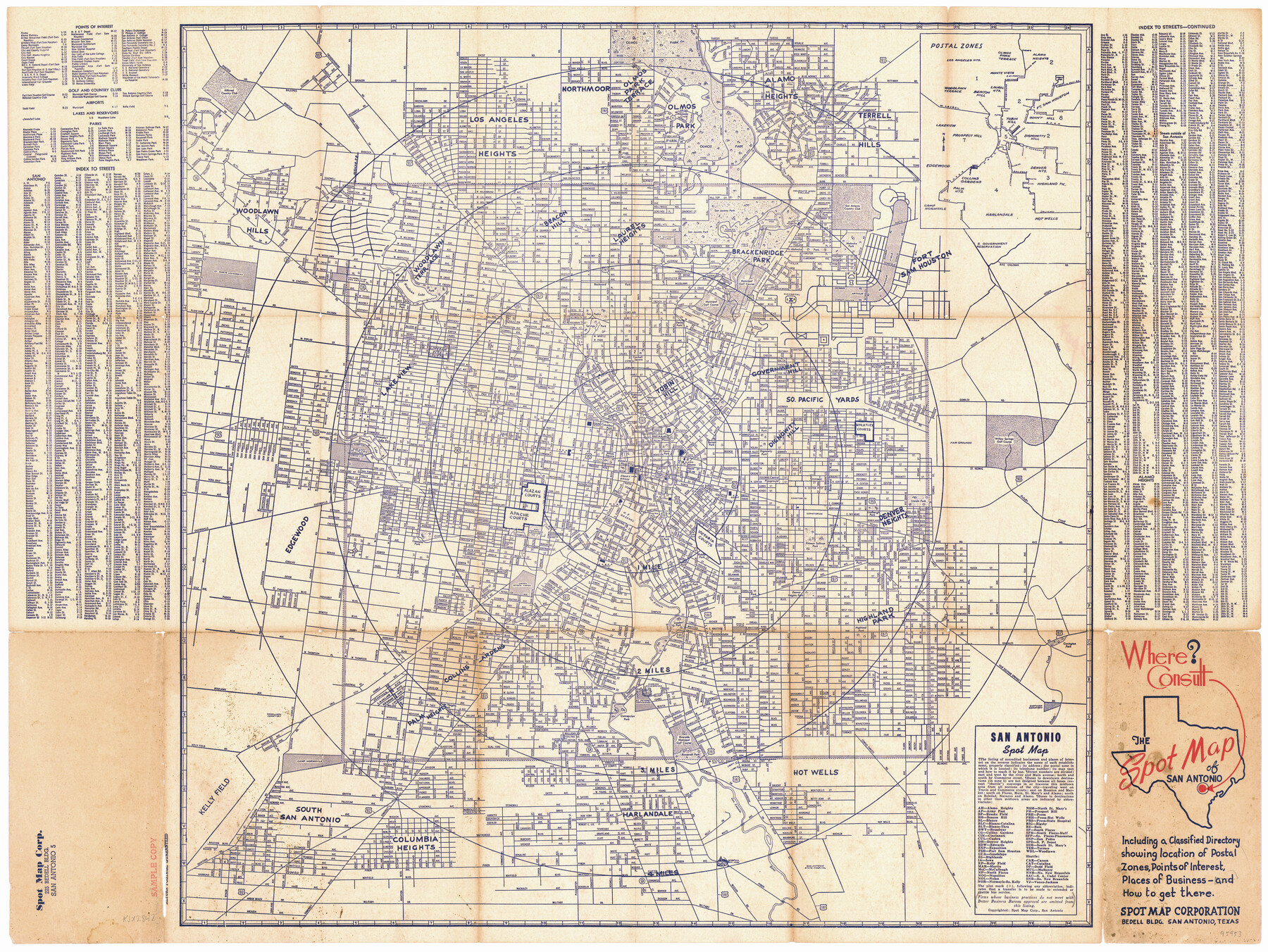
The Spot Map of San Antonio including a classified directory showing location of postal zones, points of interest, places of business - and how to get there
[Printer's Proof Copy]
-
Map/Doc
95953
-
Collection
General Map Collection
-
Object Dates
[1941 ca.] (Creation Date)
-
People and Organizations
Spot Map Corporation (Publisher)
-
Subjects
City
-
Height x Width
21.2 x 28.2 inches
53.9 x 71.6 cm
-
Medium
paper, etching/engraving/lithograph
-
Comments
Printer's proof copy. To view hand-written notes written over business directory on verso, click "Download PDF" link above.
Part of: General Map Collection
Flight Mission No. DIX-8P, Frame 94, Aransas County

Print $20.00
- Digital $50.00
Flight Mission No. DIX-8P, Frame 94, Aransas County
1956
Size 18.5 x 22.3 inches
Map/Doc 83919
Flight Mission No. DQN-2K, Frame 22, Calhoun County

Print $20.00
- Digital $50.00
Flight Mission No. DQN-2K, Frame 22, Calhoun County
1953
Size 16.9 x 18.9 inches
Map/Doc 84229
Map of Carson County

Print $20.00
- Digital $50.00
Map of Carson County
1898
Size 40.7 x 37.6 inches
Map/Doc 4904
Hunt County Rolled Sketch 5

Print $20.00
- Digital $50.00
Hunt County Rolled Sketch 5
1956
Size 22.9 x 23.0 inches
Map/Doc 6271
Taylor County, Texas

Print $20.00
- Digital $50.00
Taylor County, Texas
1890
Size 28.7 x 21.6 inches
Map/Doc 574
Rockwall County Boundary File 4a

Print $10.00
- Digital $50.00
Rockwall County Boundary File 4a
Size 11.2 x 8.8 inches
Map/Doc 58399

City of Washington

Print $20.00
- Digital $50.00
City of Washington
1846
Size 14.1 x 18.0 inches
Map/Doc 95358
Red River, Bois D'Arc Creek Floodway Sheet No. 4

Print $20.00
- Digital $50.00
Red River, Bois D'Arc Creek Floodway Sheet No. 4
1917
Size 20.3 x 28.9 inches
Map/Doc 69659
Duval County Working Sketch 27

Print $20.00
- Digital $50.00
Duval County Working Sketch 27
1947
Size 20.7 x 16.8 inches
Map/Doc 68751
Houston County Sketch File 31

Print $2.00
- Digital $50.00
Houston County Sketch File 31
1888
Size 9.1 x 7.9 inches
Map/Doc 26808
G. C. & S. F. Ry. Northern-Division, Alignment and Right of Way Map, Weatherford Branch, Johnson and Hood Counties, Texas

Print $40.00
- Digital $50.00
G. C. & S. F. Ry. Northern-Division, Alignment and Right of Way Map, Weatherford Branch, Johnson and Hood Counties, Texas
1935
Size 37.8 x 100.5 inches
Map/Doc 64649
You may also like
Maverick County Sketch File 19

Print $4.00
- Digital $50.00
Maverick County Sketch File 19
1887
Size 12.8 x 9.0 inches
Map/Doc 31128
Bandera County Sketch File 8

Print $6.00
- Digital $50.00
Bandera County Sketch File 8
1878
Size 13.0 x 11.8 inches
Map/Doc 14007
Lipscomb County Working Sketch 8

Print $20.00
- Digital $50.00
Lipscomb County Working Sketch 8
1982
Size 42.7 x 23.6 inches
Map/Doc 70584
Montague County Sketch File 20

Print $42.00
- Digital $50.00
Montague County Sketch File 20
1923
Size 34.6 x 19.8 inches
Map/Doc 12106
Working Sketch in Crosby Co.

Print $20.00
- Digital $50.00
Working Sketch in Crosby Co.
1906
Size 17.5 x 17.9 inches
Map/Doc 90350
Soil Map - Ohio-Michigan, Toledo Set

Print $20.00
- Digital $50.00
Soil Map - Ohio-Michigan, Toledo Set
1902
Size 21.4 x 30.5 inches
Map/Doc 3023
Comal County Working Sketch 4

Print $20.00
- Digital $50.00
Comal County Working Sketch 4
1950
Size 38.3 x 24.3 inches
Map/Doc 68170
Galveston Bay Entrance - Galveston and Texas City Harbors

Print $40.00
- Digital $50.00
Galveston Bay Entrance - Galveston and Texas City Harbors
1973
Size 37.0 x 53.0 inches
Map/Doc 69863
Dickens County Rolled Sketch C & C1

Print $35.00
- Digital $50.00
Dickens County Rolled Sketch C & C1
1895
Size 10.6 x 15.5 inches
Map/Doc 44297
Galveston County NRC Article 33.136 Sketch 79

Print $292.00
- Digital $50.00
Galveston County NRC Article 33.136 Sketch 79
2015
Size 22.0 x 34.0 inches
Map/Doc 94880
Starr County Rolled Sketch 25

Print $20.00
- Digital $50.00
Starr County Rolled Sketch 25
1939
Size 28.0 x 38.5 inches
Map/Doc 7809
Plan C, Part 3rd This plan represents that portion of the boundary between the Republic of Texas and the United States included between the 72nd mile mound and Red River

Print $20.00
- Digital $50.00
Plan C, Part 3rd This plan represents that portion of the boundary between the Republic of Texas and the United States included between the 72nd mile mound and Red River
1842
Size 19.3 x 27.2 inches
Map/Doc 65414