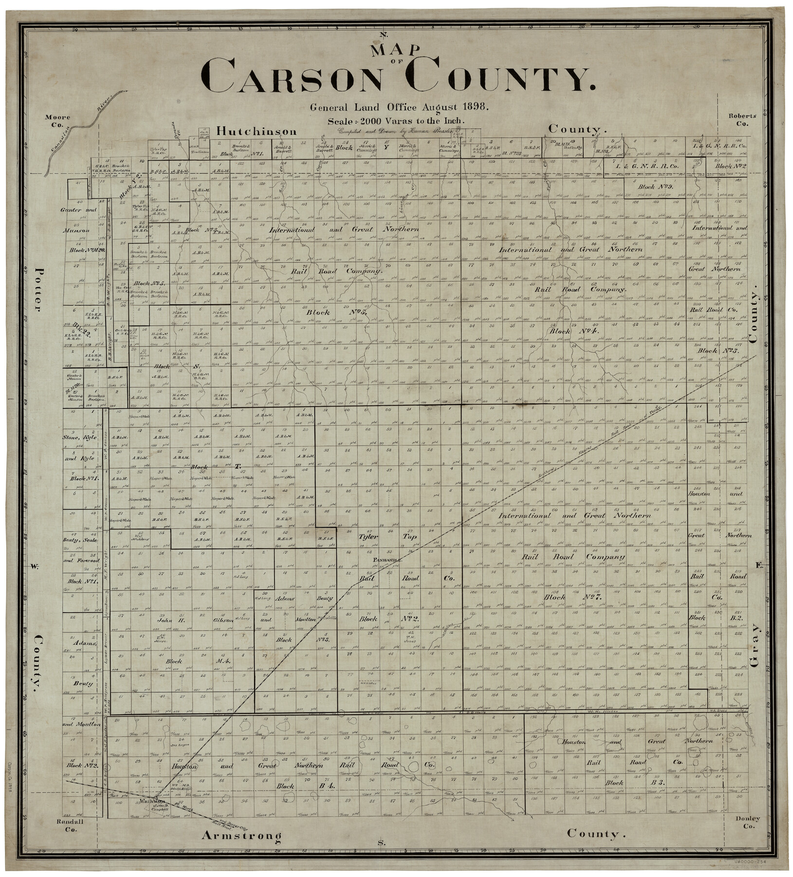
Map of Carson County
-
Map/Doc
4904
-
Collection
General Map Collection
-
Object Dates
8/1898 (Creation Date)
-
People and Organizations
Texas General Land Office (Publisher)
Herman Pressler (Draftsman)
Herman Pressler (Compiler)
-
Counties
Carson
-
Subjects
County
-
Height x Width
40.7 x 37.6 inches
103.4 x 95.5 cm
Part of: General Map Collection
Maps of Gulf Intracoastal Waterway, Texas - Sabine River to the Rio Grande and connecting waterways including ship channels

Print $20.00
- Digital $50.00
Maps of Gulf Intracoastal Waterway, Texas - Sabine River to the Rio Grande and connecting waterways including ship channels
1966
Size 14.5 x 22.2 inches
Map/Doc 61919
Orange County Sketch File 9a

Print $4.00
- Digital $50.00
Orange County Sketch File 9a
1873
Size 8.1 x 7.5 inches
Map/Doc 33313
Pass Cavallo, Entrance to Matagorda Bay, Texas

Print $20.00
- Digital $50.00
Pass Cavallo, Entrance to Matagorda Bay, Texas
1882
Size 24.3 x 18.7 inches
Map/Doc 73375
Polk County Working Sketch 28

Print $40.00
- Digital $50.00
Polk County Working Sketch 28
1960
Size 53.5 x 43.6 inches
Map/Doc 71644
Stonewall County Rolled Sketch 36B

Print $20.00
- Digital $50.00
Stonewall County Rolled Sketch 36B
Size 35.2 x 22.8 inches
Map/Doc 76404
Fractional Township No. 8 South Range No. 6 West of the Indian Meridian, Indian Territory

Print $20.00
- Digital $50.00
Fractional Township No. 8 South Range No. 6 West of the Indian Meridian, Indian Territory
1898
Size 19.3 x 24.4 inches
Map/Doc 75187
Flight Mission No. CRE-1R, Frame 194, Jackson County

Print $20.00
- Digital $50.00
Flight Mission No. CRE-1R, Frame 194, Jackson County
1956
Size 18.5 x 22.3 inches
Map/Doc 85348
Deaf Smith County Rolled Sketch 3

Print $20.00
- Digital $50.00
Deaf Smith County Rolled Sketch 3
Size 23.9 x 18.0 inches
Map/Doc 95707
Waller County Sketch File 1

Print $14.00
- Digital $50.00
Waller County Sketch File 1
Size 8.1 x 6.9 inches
Map/Doc 39563
Pecos County Working Sketch 111

Print $40.00
- Digital $50.00
Pecos County Working Sketch 111
1972
Size 32.9 x 69.6 inches
Map/Doc 71584
La Salle County Working Sketch 29

Print $20.00
- Digital $50.00
La Salle County Working Sketch 29
1955
Size 25.8 x 27.4 inches
Map/Doc 70330
Bastrop County Sketch File 13

Print $6.00
- Digital $50.00
Bastrop County Sketch File 13
1845
Size 10.1 x 15.8 inches
Map/Doc 14070
You may also like
Winkler County

Print $20.00
- Digital $50.00
Winkler County
1890
Size 22.8 x 18.5 inches
Map/Doc 4160
Flight Mission No. DAG-28K, Frame 31, Matagorda County

Print $20.00
- Digital $50.00
Flight Mission No. DAG-28K, Frame 31, Matagorda County
1953
Size 16.1 x 16.2 inches
Map/Doc 86599
Real County Working Sketch 17

Print $20.00
- Digital $50.00
Real County Working Sketch 17
1941
Size 18.8 x 24.3 inches
Map/Doc 71909
Hidalgo County Sketch File 6

Print $4.00
- Digital $50.00
Hidalgo County Sketch File 6
1891
Size 10.3 x 8.4 inches
Map/Doc 26403
Aransas County Sketch File 17

Print $40.00
- Digital $50.00
Aransas County Sketch File 17
Size 28.4 x 16.7 inches
Map/Doc 10822
Bell County, Texas

Print $20.00
- Digital $50.00
Bell County, Texas
1879
Size 23.7 x 29.0 inches
Map/Doc 516
Runnels County Rolled Sketch 29

Print $20.00
- Digital $50.00
Runnels County Rolled Sketch 29
1928
Size 19.6 x 37.0 inches
Map/Doc 7517
Archer County Sketch File B-1

Print $40.00
- Digital $50.00
Archer County Sketch File B-1
Size 34.5 x 38.8 inches
Map/Doc 10370
Brazoria County NRC Article 33.136 Sketch 3

Print $20.00
- Digital $50.00
Brazoria County NRC Article 33.136 Sketch 3
2002
Size 40.6 x 29.6 inches
Map/Doc 77039

[Surveying Sketch of John Knight, Champion Choate, A.M. Lejarza, et al in Hardin County, Texas - Exhibit "G"]
![75822, [Surveying Sketch of John Knight, Champion Choate, A.M. Lejarza, et al in Hardin County, Texas - Exhibit "G"], Maddox Collection](https://historictexasmaps.com/wmedia_w700/maps/75822.tif.jpg)
Print $20.00
- Digital $50.00
[Surveying Sketch of John Knight, Champion Choate, A.M. Lejarza, et al in Hardin County, Texas - Exhibit "G"]
Size 18.3 x 23.5 inches
Map/Doc 75822
Township 12 North Range 16 West, North Western District, Louisiana

Print $20.00
- Digital $50.00
Township 12 North Range 16 West, North Western District, Louisiana
1837
Size 19.7 x 24.8 inches
Map/Doc 65868