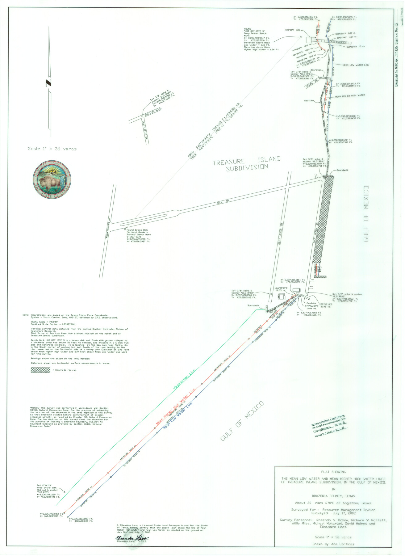
Brazoria County NRC Article 33.136 Sketch 3
Mean Low Water and Mean Higher High Water Lines of Treasure Island Subdivision in the Gulf of Mexico
-
Map/Doc
77039
-
Collection
General Map Collection
-
Object Dates
2002/7/17 (Creation Date)
2002/7/17 (File Date)
-
People and Organizations
Texas General Land Office (Publisher)
Texas General Land Office (Printer)
Ana C. Cortinas (Compiler)
Ana C. Cortinas (Draftsman)
David Dewhurst (GLO Commissioner)
Elisandro Leos (Surveyor/Engineer)
-
Counties
Brazoria
-
Subjects
Surveying CBS
-
Height x Width
40.6 x 29.6 inches
103.1 x 75.2 cm
-
Medium
mylar, print
-
Comments
Survey located about 20 miles South 72 degrees East of Angleton, Texas.
Part of: General Map Collection
Edwards County

Print $40.00
- Digital $50.00
Edwards County
1900
Size 56.4 x 27.3 inches
Map/Doc 87471
Map of Lampasas Co.

Print $20.00
- Digital $50.00
Map of Lampasas Co.
1888
Size 34.4 x 42.4 inches
Map/Doc 5080
Texas & Pacific Railway, Longview to Dallas

Print $40.00
- Digital $50.00
Texas & Pacific Railway, Longview to Dallas
1873
Size 14.8 x 100.8 inches
Map/Doc 64099
Texas, Intracoastal Waterway, Ayres Bay to Aransas Bay

Print $40.00
- Digital $50.00
Texas, Intracoastal Waterway, Ayres Bay to Aransas Bay
1934
Size 33.2 x 48.5 inches
Map/Doc 69997
Map of Liberty County

Print $40.00
- Digital $50.00
Map of Liberty County
1841
Size 60.1 x 37.3 inches
Map/Doc 1951
[Sketch for Mineral Application 26501 - Sabine River, T. A. Oldhausen]
![2846, [Sketch for Mineral Application 26501 - Sabine River, T. A. Oldhausen], General Map Collection](https://historictexasmaps.com/wmedia_w700/maps/2846.tif.jpg)
Print $20.00
- Digital $50.00
[Sketch for Mineral Application 26501 - Sabine River, T. A. Oldhausen]
1931
Size 24.4 x 37.0 inches
Map/Doc 2846
McMullen County Working Sketch 27

Print $40.00
- Digital $50.00
McMullen County Working Sketch 27
1953
Size 53.2 x 32.9 inches
Map/Doc 70728
Brewster County Rolled Sketch 62

Print $40.00
- Digital $50.00
Brewster County Rolled Sketch 62
1939
Size 89.5 x 44.0 inches
Map/Doc 8487
Orange County Working Sketch 5

Print $20.00
- Digital $50.00
Orange County Working Sketch 5
1917
Size 12.6 x 20.6 inches
Map/Doc 71337
Location Map of Chicago, Rock Island & Texas Railroad

Print $20.00
- Digital $50.00
Location Map of Chicago, Rock Island & Texas Railroad
Size 21.3 x 45.9 inches
Map/Doc 64473
Milam County Boundary File 2a

Print $10.00
- Digital $50.00
Milam County Boundary File 2a
Size 10.6 x 8.0 inches
Map/Doc 57208

You may also like
The Republic County of Harris. January 25, 1840

Print $20.00
The Republic County of Harris. January 25, 1840
2020
Size 17.7 x 21.7 inches
Map/Doc 96165
Missouri, Kansas & Texas Ry. thro' Denison and the beautiful Indian Territory

Print $20.00
- Digital $50.00
Missouri, Kansas & Texas Ry. thro' Denison and the beautiful Indian Territory
1877
Size 15.7 x 21.7 inches
Map/Doc 95805
Dimmit County Working Sketch 54

Print $20.00
- Digital $50.00
Dimmit County Working Sketch 54
1996
Size 27.8 x 30.0 inches
Map/Doc 68715
Brewster County Sketch File 38

Print $4.00
- Digital $50.00
Brewster County Sketch File 38
Size 12.1 x 8.9 inches
Map/Doc 16222
Parker County Sketch File 41

Print $4.00
- Digital $50.00
Parker County Sketch File 41
1877
Size 8.9 x 10.6 inches
Map/Doc 33587
Tarrant County Sketch File 21a

Print $4.00
- Digital $50.00
Tarrant County Sketch File 21a
1859
Size 8.0 x 8.1 inches
Map/Doc 37727
Upshur County Working Sketch 15a

Print $20.00
- Digital $50.00
Upshur County Working Sketch 15a
1996
Size 42.6 x 34.7 inches
Map/Doc 69573
Kimble County

Print $40.00
- Digital $50.00
Kimble County
1930
Size 43.8 x 49.2 inches
Map/Doc 73207
Wise County Working Sketch 10

Print $20.00
- Digital $50.00
Wise County Working Sketch 10
Size 17.4 x 18.4 inches
Map/Doc 72624
Reagan County Sketch File 2

Print $2.00
- Digital $50.00
Reagan County Sketch File 2
Size 10.8 x 6.6 inches
Map/Doc 34979

Angelina County Working Sketch 16

Print $20.00
- Digital $50.00
Angelina County Working Sketch 16
1935
Size 31.0 x 27.0 inches
Map/Doc 67097