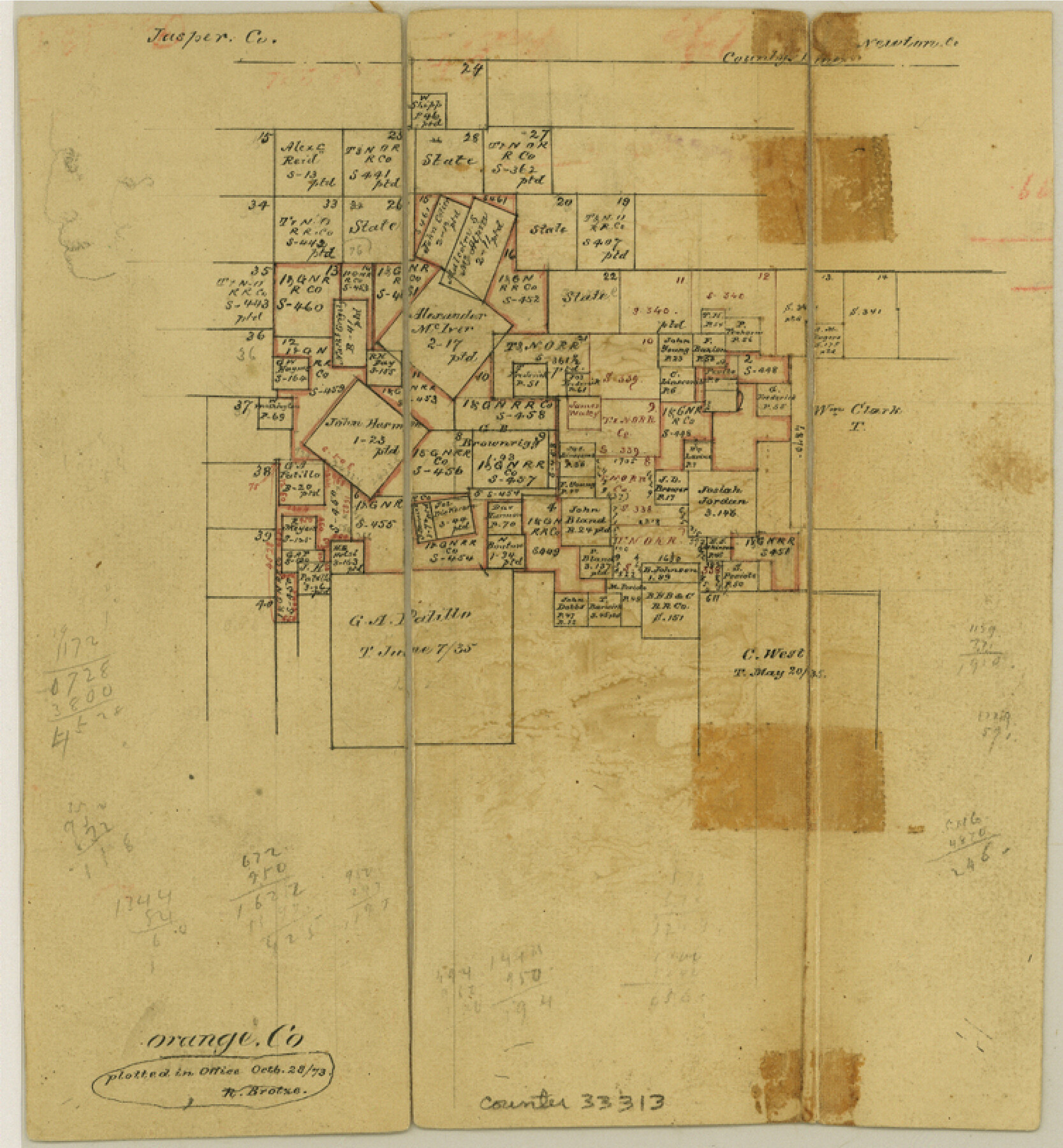
Orange County Sketch File 9a
[Office sketch of surveys in the northern part of the county]
-
Map/Doc
33313
-
Collection
General Map Collection
-
Object Dates
10/28/1873 (Creation Date)
-
Counties
Orange
-
Subjects
Surveying Sketch File
-
Height x Width
8.1 x 7.5 inches
20.6 x 19.1 cm
-
Medium
paper, manuscript
Part of: General Map Collection
Webb County Sketch File 57

Print $20.00
- Digital $50.00
Webb County Sketch File 57
1942
Size 34.0 x 17.7 inches
Map/Doc 12652
Cochran County Rolled Sketch A

Print $40.00
- Digital $50.00
Cochran County Rolled Sketch A
Size 28.5 x 55.3 inches
Map/Doc 8604
El Paso County Rolled Sketch Z60

Print $20.00
- Digital $50.00
El Paso County Rolled Sketch Z60
1915
Size 37.3 x 47.7 inches
Map/Doc 8873

Travels to the source of the Missouri River and across the American Continent to the Pacific Ocean - Vol. 1

Travels to the source of the Missouri River and across the American Continent to the Pacific Ocean - Vol. 1
1815
Map/Doc 97411
Jefferson County Working Sketch 36

Print $40.00
- Digital $50.00
Jefferson County Working Sketch 36
1982
Size 69.1 x 33.2 inches
Map/Doc 66580
Gulf Oil Corp. Fishgide - Port Isabel

Gulf Oil Corp. Fishgide - Port Isabel
1960
Size 12.1 x 22.4 inches
Map/Doc 75981
Taylor County Rolled Sketch 28

Print $20.00
- Digital $50.00
Taylor County Rolled Sketch 28
Size 34.4 x 23.9 inches
Map/Doc 7921
Aransas County Working Sketch 6

Print $20.00
- Digital $50.00
Aransas County Working Sketch 6
1943
Size 26.0 x 35.5 inches
Map/Doc 67173
Nueces County Rolled Sketch 75

Print $40.00
- Digital $50.00
Nueces County Rolled Sketch 75
1945
Size 56.0 x 24.0 inches
Map/Doc 9618
Flight Mission No. CRC-2R, Frame 109, Chambers County

Print $20.00
- Digital $50.00
Flight Mission No. CRC-2R, Frame 109, Chambers County
1956
Size 18.6 x 22.3 inches
Map/Doc 84736
Fort Bend County Sketch File 31

Print $10.00
- Digital $50.00
Fort Bend County Sketch File 31
1940
Size 13.3 x 8.7 inches
Map/Doc 22997
You may also like
Map of Bexar County

Print $40.00
- Digital $50.00
Map of Bexar County
1845
Size 49.0 x 46.5 inches
Map/Doc 87236
General Highway Map, Loving County, Texas

Print $20.00
General Highway Map, Loving County, Texas
1940
Size 18.3 x 24.8 inches
Map/Doc 79179
Galveston County Rolled Sketch 40A

Print $20.00
- Digital $50.00
Galveston County Rolled Sketch 40A
1988
Size 42.0 x 46.0 inches
Map/Doc 9020
Flight Mission No. CUG-2P, Frame 21, Kleberg County

Print $20.00
- Digital $50.00
Flight Mission No. CUG-2P, Frame 21, Kleberg County
1956
Size 18.5 x 22.3 inches
Map/Doc 86185
Hamilton County Rolled Sketch 7

Print $20.00
- Digital $50.00
Hamilton County Rolled Sketch 7
1927
Size 32.2 x 38.4 inches
Map/Doc 6057
Panorama of the seat of war - Birds eye view of Texas and part of Mexico

Print $20.00
Panorama of the seat of war - Birds eye view of Texas and part of Mexico
1861
Size 21.6 x 28.9 inches
Map/Doc 93360
Liberty County Sketch File 37

Print $15.00
- Digital $50.00
Liberty County Sketch File 37
1895
Size 14.9 x 10.0 inches
Map/Doc 29976
Culberson Co.

Print $40.00
- Digital $50.00
Culberson Co.
1908
Size 50.2 x 33.7 inches
Map/Doc 66795
Rusk County Working Sketch 32

Print $20.00
- Digital $50.00
Rusk County Working Sketch 32
1919
Size 16.7 x 17.1 inches
Map/Doc 63669
Travis County Boundary File 32

Print $5.00
- Digital $50.00
Travis County Boundary File 32
Size 11.8 x 9.4 inches
Map/Doc 59473
[H. & G. N. Blocks 1-4 and Blocks C-19, C-20, 54, 55 and 56]
![91781, [H. & G. N. Blocks 1-4 and Blocks C-19, C-20, 54, 55 and 56], Twichell Survey Records](https://historictexasmaps.com/wmedia_w700/maps/91781-1.tif.jpg)
Print $20.00
- Digital $50.00
[H. & G. N. Blocks 1-4 and Blocks C-19, C-20, 54, 55 and 56]
Size 23.3 x 29.3 inches
Map/Doc 91781
General Highway Map, Parker County, Texas

Print $20.00
General Highway Map, Parker County, Texas
1940
Size 18.3 x 24.7 inches
Map/Doc 79215