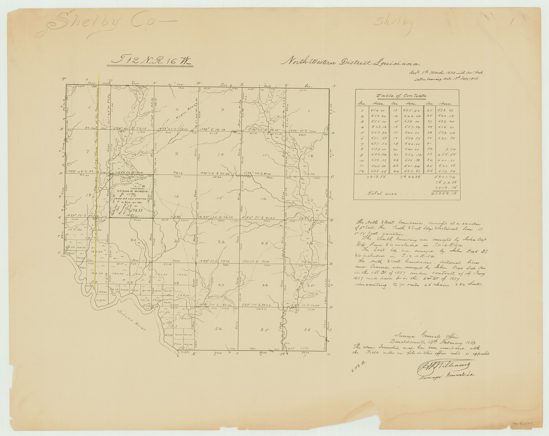
Township 12 North Range 16 West, North Western District, Louisiana
Louisiana Land Surveys Across From Shelby County, Texas 1
-
Map/Doc
65868
-
Collection
General Map Collection
-
Object Dates
1837 (Creation Date)
-
People and Organizations
Surveyor General's Office Louisiana (Publisher)
John Boyd (Surveyor/Engineer)
-
Subjects
Texas Boundaries
-
Height x Width
19.7 x 24.8 inches
50.0 x 63.0 cm
Part of: General Map Collection
Location of the Southern Kansas Railway of Texas through Hemphill County, Texas

Print $40.00
- Digital $50.00
Location of the Southern Kansas Railway of Texas through Hemphill County, Texas
1887
Size 20.1 x 104.9 inches
Map/Doc 64034
Burnet County Rolled Sketch 5

Print $40.00
- Digital $50.00
Burnet County Rolled Sketch 5
1971
Size 36.5 x 49.6 inches
Map/Doc 8542
United States - Gulf Coast Texas - Northern part of Laguna Madre

Print $20.00
- Digital $50.00
United States - Gulf Coast Texas - Northern part of Laguna Madre
1941
Size 26.7 x 18.4 inches
Map/Doc 72933
Bandera County Sketch File 19

Print $40.00
- Digital $50.00
Bandera County Sketch File 19
Size 15.9 x 18.9 inches
Map/Doc 10893
Webb County Sketch File 14

Print $7.00
- Digital $50.00
Webb County Sketch File 14
1877
Size 10.0 x 8.2 inches
Map/Doc 39807
Hartley County Sketch File 15

Print $20.00
- Digital $50.00
Hartley County Sketch File 15
Size 31.2 x 16.6 inches
Map/Doc 11737
Denton County Sketch File 27

Print $4.00
- Digital $50.00
Denton County Sketch File 27
1858
Size 7.9 x 12.1 inches
Map/Doc 20754
Coleman County

Print $40.00
- Digital $50.00
Coleman County
1945
Size 54.7 x 37.1 inches
Map/Doc 73109
Pecos County Working Sketch 53

Print $20.00
- Digital $50.00
Pecos County Working Sketch 53
1948
Size 37.6 x 25.8 inches
Map/Doc 71525
Calhoun County NRC Article 33.136 Sketch 7

Print $63.00
- Digital $50.00
Calhoun County NRC Article 33.136 Sketch 7
2016
Size 17.1 x 21.8 inches
Map/Doc 94867
Jeff Davis County Rolled Sketch 13

Print $73.00
- Digital $50.00
Jeff Davis County Rolled Sketch 13
1921
Size 20.0 x 23.3 inches
Map/Doc 6366
Map of Mexico, Including Yucatan & Upper California, exhibiting the Chief Cities and Towns, the Principal Travelling Routes &c.

Print $20.00
- Digital $50.00
Map of Mexico, Including Yucatan & Upper California, exhibiting the Chief Cities and Towns, the Principal Travelling Routes &c.
1847
Size 33.3 x 25.4 inches
Map/Doc 95697
You may also like

Val Verde County Sketch File C

Print $62.00
- Digital $50.00
Val Verde County Sketch File C
1898
Size 15.5 x 19.8 inches
Map/Doc 12545
[Capitol Leagues 294, 295, 301, 302, 303, and 304]
![91422, [Capitol Leagues 294, 295, 301, 302, 303, and 304], Twichell Survey Records](https://historictexasmaps.com/wmedia_w700/maps/91422-1.tif.jpg)
Print $20.00
- Digital $50.00
[Capitol Leagues 294, 295, 301, 302, 303, and 304]
1883
Size 16.1 x 12.5 inches
Map/Doc 91422
Matagorda County Working Sketch 19

Print $20.00
- Digital $50.00
Matagorda County Working Sketch 19
1961
Size 31.7 x 42.3 inches
Map/Doc 70877
Reeves County Rolled Sketch 32

Print $634.00
- Digital $50.00
Reeves County Rolled Sketch 32
1960
Size 10.2 x 15.4 inches
Map/Doc 48849
Intracoastal Waterway - Galveston Bay to West Bay including Galveston Bay Entrance

Print $20.00
- Digital $50.00
Intracoastal Waterway - Galveston Bay to West Bay including Galveston Bay Entrance
1957
Size 27.2 x 38.6 inches
Map/Doc 69932
Flight Mission No. BQR-9K, Frame 4, Brazoria County

Print $20.00
- Digital $50.00
Flight Mission No. BQR-9K, Frame 4, Brazoria County
1952
Size 18.8 x 22.3 inches
Map/Doc 84033
Station Map, the Missouri, Kansas and Texas Ry. Of Texas - Henrietta Division

Print $20.00
- Digital $50.00
Station Map, the Missouri, Kansas and Texas Ry. Of Texas - Henrietta Division
1918
Size 11.8 x 26.7 inches
Map/Doc 64763
Brazoria County NRC Article 33.136 Sketch 18

Print $24.00
- Digital $50.00
Brazoria County NRC Article 33.136 Sketch 18
2015
Size 24.0 x 36.0 inches
Map/Doc 95066
Atascosa County Working Sketch 26

Print $20.00
- Digital $50.00
Atascosa County Working Sketch 26
1960
Size 46.9 x 43.7 inches
Map/Doc 67222
Eastland County Working Sketch 30

Print $20.00
- Digital $50.00
Eastland County Working Sketch 30
1954
Size 20.2 x 24.0 inches
Map/Doc 68811
Flight Mission No. DCL-3C, Frame 155, Kenedy County

Print $20.00
- Digital $50.00
Flight Mission No. DCL-3C, Frame 155, Kenedy County
1943
Size 18.6 x 22.4 inches
Map/Doc 85803