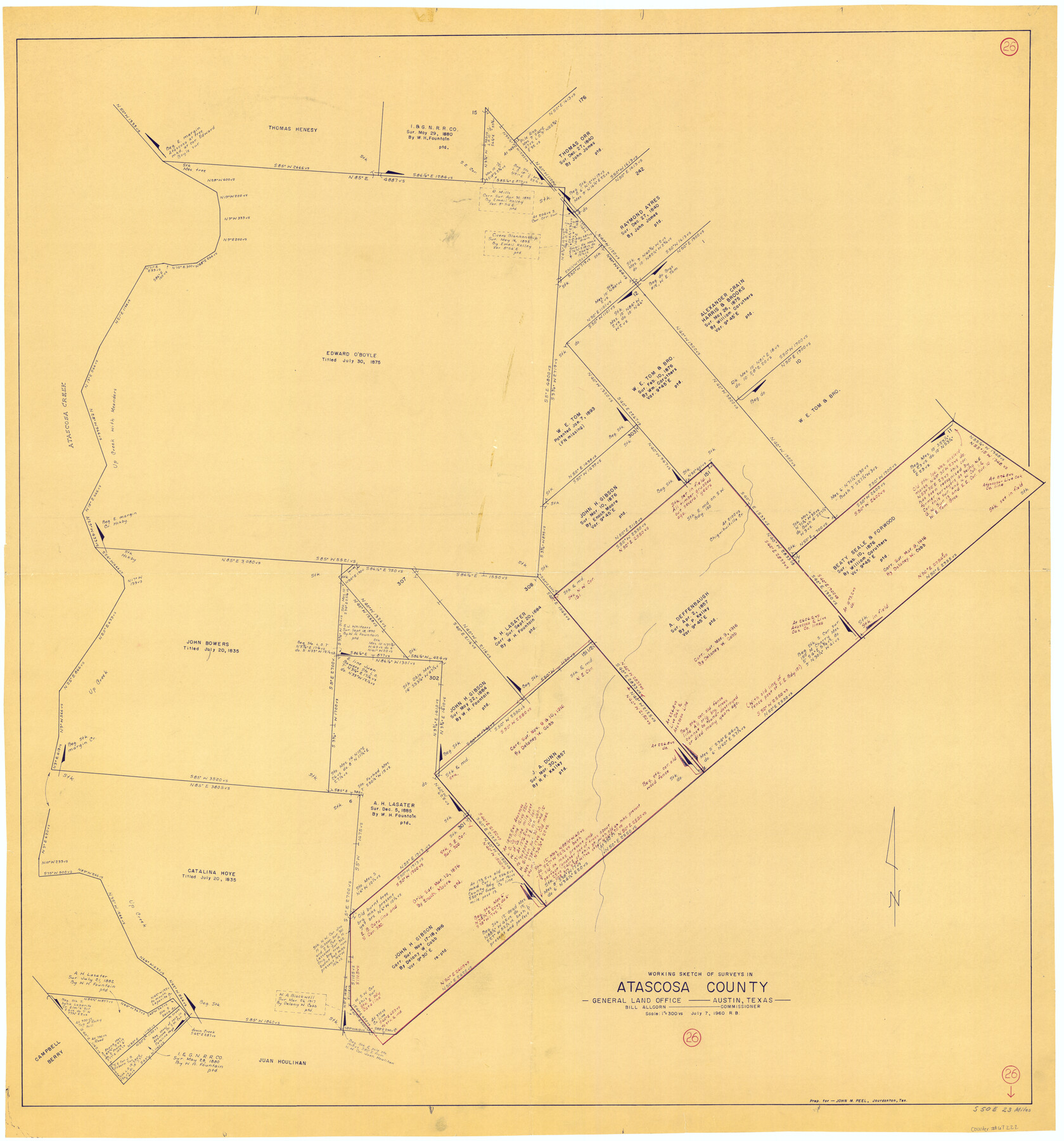
Atascosa County Working Sketch 26
-
Map/Doc
67222
-
Collection
General Map Collection
-
Object Dates
7/7/1960 (Creation Date)
-
People and Organizations
Roy Buckholts (Draftsman)
Bill Allcorn (GLO Commissioner)
-
Counties
Atascosa
-
Subjects
Surveying Working Sketch
-
Height x Width
46.9 x 43.7 inches
119.1 x 111.0 cm
-
Scale
1" = 300 varas
-
Comments
Surveys located about 23 miles South 50 degrees East of Jourdanton, Texas.
Part of: General Map Collection
Kinney County Rolled Sketch 17

Print $20.00
- Digital $50.00
Kinney County Rolled Sketch 17
1965
Size 18.4 x 21.5 inches
Map/Doc 6544
La Salle County Working Sketch 18

Print $20.00
- Digital $50.00
La Salle County Working Sketch 18
1940
Size 42.5 x 43.3 inches
Map/Doc 70319
Voyages Autour du Monde, et vers les deux poles par terre et par mer - Tome Premier

Voyages Autour du Monde, et vers les deux poles par terre et par mer - Tome Premier
1782
Map/Doc 97085
Yoakum County Sketch File 17

Print $48.00
- Digital $50.00
Yoakum County Sketch File 17
1898
Size 14.5 x 8.9 inches
Map/Doc 40796
No. 1 - Survey for a road from the Brazo Santiago to the Rio Grande

Print $20.00
- Digital $50.00
No. 1 - Survey for a road from the Brazo Santiago to the Rio Grande
1847
Size 18.3 x 27.1 inches
Map/Doc 72876
Dimmit County Working Sketch 47

Print $40.00
- Digital $50.00
Dimmit County Working Sketch 47
1980
Size 71.3 x 43.8 inches
Map/Doc 68708
Goliad County Sketch File 13

Print $8.00
- Digital $50.00
Goliad County Sketch File 13
1856
Size 12.4 x 8.0 inches
Map/Doc 24239
Wichita County Sketch File 3

Print $8.00
- Digital $50.00
Wichita County Sketch File 3
1856
Size 7.2 x 16.3 inches
Map/Doc 40033
Reeves County Working Sketch 51

Print $20.00
- Digital $50.00
Reeves County Working Sketch 51
1974
Size 45.4 x 34.6 inches
Map/Doc 63494
McMullen County Sketch File 21

Print $4.00
- Digital $50.00
McMullen County Sketch File 21
1876
Size 10.0 x 8.0 inches
Map/Doc 31375
Goliad County Sketch File 26

Print $26.00
- Digital $50.00
Goliad County Sketch File 26
1855
Size 10.2 x 8.2 inches
Map/Doc 24308
Brazoria County Rolled Sketch 31

Print $20.00
- Digital $50.00
Brazoria County Rolled Sketch 31
Size 25.6 x 45.9 inches
Map/Doc 5169
You may also like
Rhyne Simpson Addition City of Lubbock Section 3, Block O

Print $20.00
- Digital $50.00
Rhyne Simpson Addition City of Lubbock Section 3, Block O
1951
Size 18.2 x 23.4 inches
Map/Doc 92845
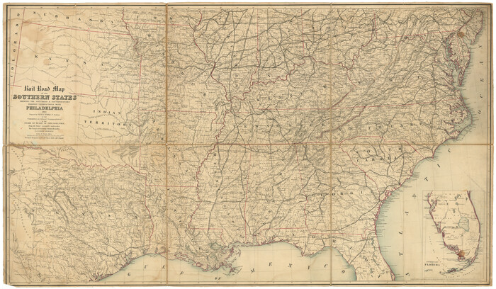
Rail Road Map of the Southern States shewing the Southern & Southwestern Railway Connections with Philadelphia
Print $40.00
- Digital $50.00
Rail Road Map of the Southern States shewing the Southern & Southwestern Railway Connections with Philadelphia
1862
Size 31.6 x 54.1 inches
Map/Doc 97482
[Township 3 North, Block 33]
![91215, [Township 3 North, Block 33], Twichell Survey Records](https://historictexasmaps.com/wmedia_w700/maps/91215-1.tif.jpg)
Print $3.00
- Digital $50.00
[Township 3 North, Block 33]
Size 11.2 x 17.0 inches
Map/Doc 91215
Borden County

Print $20.00
- Digital $50.00
Borden County
1892
Size 44.1 x 44.1 inches
Map/Doc 66717
A Trip to Winter Garden District, Carrizo Springs, Texas in the Shallow Water Area of the Famous Artesian Belt

Print $20.00
- Digital $50.00
A Trip to Winter Garden District, Carrizo Springs, Texas in the Shallow Water Area of the Famous Artesian Belt
1920
Size 8.9 x 15.5 inches
Map/Doc 96766
Terrell County Working Sketch Graphic index - sheet B

Print $20.00
- Digital $50.00
Terrell County Working Sketch Graphic index - sheet B
1931
Size 47.7 x 39.6 inches
Map/Doc 76711
Colorado River, Brackenridge Tract

Print $20.00
- Digital $50.00
Colorado River, Brackenridge Tract
1927
Size 43.6 x 32.1 inches
Map/Doc 65325
Webb County Working Sketch 41

Print $20.00
- Digital $50.00
Webb County Working Sketch 41
1941
Size 15.7 x 18.8 inches
Map/Doc 72406
Sutton County Working Sketch 19

Print $20.00
- Digital $50.00
Sutton County Working Sketch 19
1978
Size 37.7 x 39.0 inches
Map/Doc 62362
Right of Way and Track Map, Texas & New Orleans R.R. operated by the T. & N. O. R.R. Co., Rusk Branch

Print $40.00
- Digital $50.00
Right of Way and Track Map, Texas & New Orleans R.R. operated by the T. & N. O. R.R. Co., Rusk Branch
1918
Size 24.9 x 55.9 inches
Map/Doc 64242
Lee County Working Sketch 9

Print $20.00
- Digital $50.00
Lee County Working Sketch 9
1979
Size 26.7 x 28.0 inches
Map/Doc 70388
[Block 1, B. S. & F.]
![90492, [Block 1, B. S. & F.], Twichell Survey Records](https://historictexasmaps.com/wmedia_w700/maps/90492-1.tif.jpg)
Print $2.00
- Digital $50.00
[Block 1, B. S. & F.]
1904
Size 8.3 x 10.5 inches
Map/Doc 90492