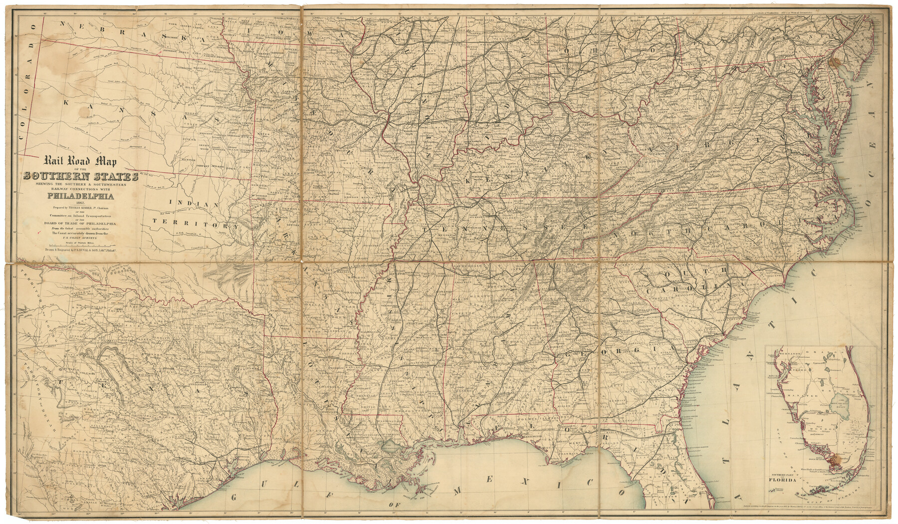
Rail Road Map of the Southern States shewing the Southern & Southwestern Railway Connections with Philadelphia
-
Map/Doc
97482
-
Collection
General Map Collection
-
Object Dates
1862 (Creation Date)
-
People and Organizations
Thomas Kimber, Jr. (Compiler)
P.S. Duval & Son (Engraver)
-
Subjects
Railroads United States
-
Height x Width
31.6 x 54.1 inches
80.3 x 137.4 cm
Part of: General Map Collection
Burleson County Rolled Sketch 1

Print $631.00
- Digital $50.00
Burleson County Rolled Sketch 1
Size 10.2 x 16.5 inches
Map/Doc 43342
Wise County Working Sketch 2

Print $20.00
- Digital $50.00
Wise County Working Sketch 2
1940
Size 30.1 x 41.9 inches
Map/Doc 72616
Hemphill County Sketch File 5

Print $8.00
- Digital $50.00
Hemphill County Sketch File 5
1903
Size 11.2 x 8.8 inches
Map/Doc 26295
Right of Way & Track Map, St. Louis, Brownsville & Mexico Ry. operated by St. Louis, Brownsville & Mexico Ry. Co.

Print $40.00
- Digital $50.00
Right of Way & Track Map, St. Louis, Brownsville & Mexico Ry. operated by St. Louis, Brownsville & Mexico Ry. Co.
1919
Size 25.4 x 56.9 inches
Map/Doc 64614
Current Miscellaneous File 10

Print $8.00
- Digital $50.00
Current Miscellaneous File 10
1916
Size 11.4 x 8.8 inches
Map/Doc 73774
Map of San Jacinto County

Print $20.00
- Digital $50.00
Map of San Jacinto County
1879
Size 27.0 x 18.1 inches
Map/Doc 4624
Presidio County Sketch File 53

Print $24.00
- Digital $50.00
Presidio County Sketch File 53
1928
Size 16.6 x 8.8 inches
Map/Doc 34610
Val Verde County Sketch File 44A

Print $10.00
- Digital $50.00
Val Verde County Sketch File 44A
1940
Size 14.5 x 8.8 inches
Map/Doc 39311
San Patricio County Rolled Sketch 35A

Print $20.00
- Digital $50.00
San Patricio County Rolled Sketch 35A
1958
Size 23.1 x 17.4 inches
Map/Doc 7587
Gonzales County Sketch File 4

Print $4.00
- Digital $50.00
Gonzales County Sketch File 4
Size 12.6 x 8.0 inches
Map/Doc 24373
Flight Mission No. BRE-1P, Frame 31, Nueces County

Print $20.00
- Digital $50.00
Flight Mission No. BRE-1P, Frame 31, Nueces County
1956
Size 18.0 x 21.6 inches
Map/Doc 86627
Reagan County Working Sketch 9

Print $20.00
- Digital $50.00
Reagan County Working Sketch 9
1939
Size 12.4 x 24.2 inches
Map/Doc 71849
You may also like
Hutchinson County Rolled Sketch 44-2

Print $20.00
- Digital $50.00
Hutchinson County Rolled Sketch 44-2
2002
Size 24.0 x 36.0 inches
Map/Doc 77538
Montgomery County Working Sketch 67

Print $20.00
- Digital $50.00
Montgomery County Working Sketch 67
1972
Size 35.0 x 29.6 inches
Map/Doc 71174
The Judicial District/County of Spring Creek. Created, January 21, 1841

Print $20.00
The Judicial District/County of Spring Creek. Created, January 21, 1841
2020
Size 15.7 x 21.7 inches
Map/Doc 96348
Sketch Showing D. Rubin Surveys

Print $20.00
- Digital $50.00
Sketch Showing D. Rubin Surveys
1926
Size 35.1 x 24.5 inches
Map/Doc 91165
The Rand McNally New Commercial Atlas Map of Texas

Print $20.00
- Digital $50.00
The Rand McNally New Commercial Atlas Map of Texas
1917
Size 28.7 x 40.6 inches
Map/Doc 95850
Jim Hogg County Rolled Sketch 14

Print $20.00
- Digital $50.00
Jim Hogg County Rolled Sketch 14
2023
Size 21.1 x 30.3 inches
Map/Doc 97155
Texas Land Commissioner George P. Bush's Energy Map of Texas Showing Significant Events and Well & Pipeline Locations Between 1543 and 2015

Print $20.00
- Digital $50.00
Texas Land Commissioner George P. Bush's Energy Map of Texas Showing Significant Events and Well & Pipeline Locations Between 1543 and 2015
2015
Size 33.3 x 36.3 inches
Map/Doc 93978
Hall County Sketch File 28

Print $20.00
- Digital $50.00
Hall County Sketch File 28
1913
Size 18.0 x 21.5 inches
Map/Doc 11611
Flight Mission No. CUG-1P, Frame 167, Kleberg County

Print $20.00
- Digital $50.00
Flight Mission No. CUG-1P, Frame 167, Kleberg County
1956
Size 18.7 x 22.4 inches
Map/Doc 86174
Tom Green County Rolled Sketch 10

Print $20.00
- Digital $50.00
Tom Green County Rolled Sketch 10
1949
Size 26.4 x 32.5 inches
Map/Doc 7997
Travis County Sketch File 78

Print $102.00
- Digital $50.00
Travis County Sketch File 78
2010
Size 11.0 x 8.5 inches
Map/Doc 90085
Sterling County Rolled Sketch 32

Print $20.00
- Digital $50.00
Sterling County Rolled Sketch 32
Size 17.9 x 29.4 inches
Map/Doc 7856