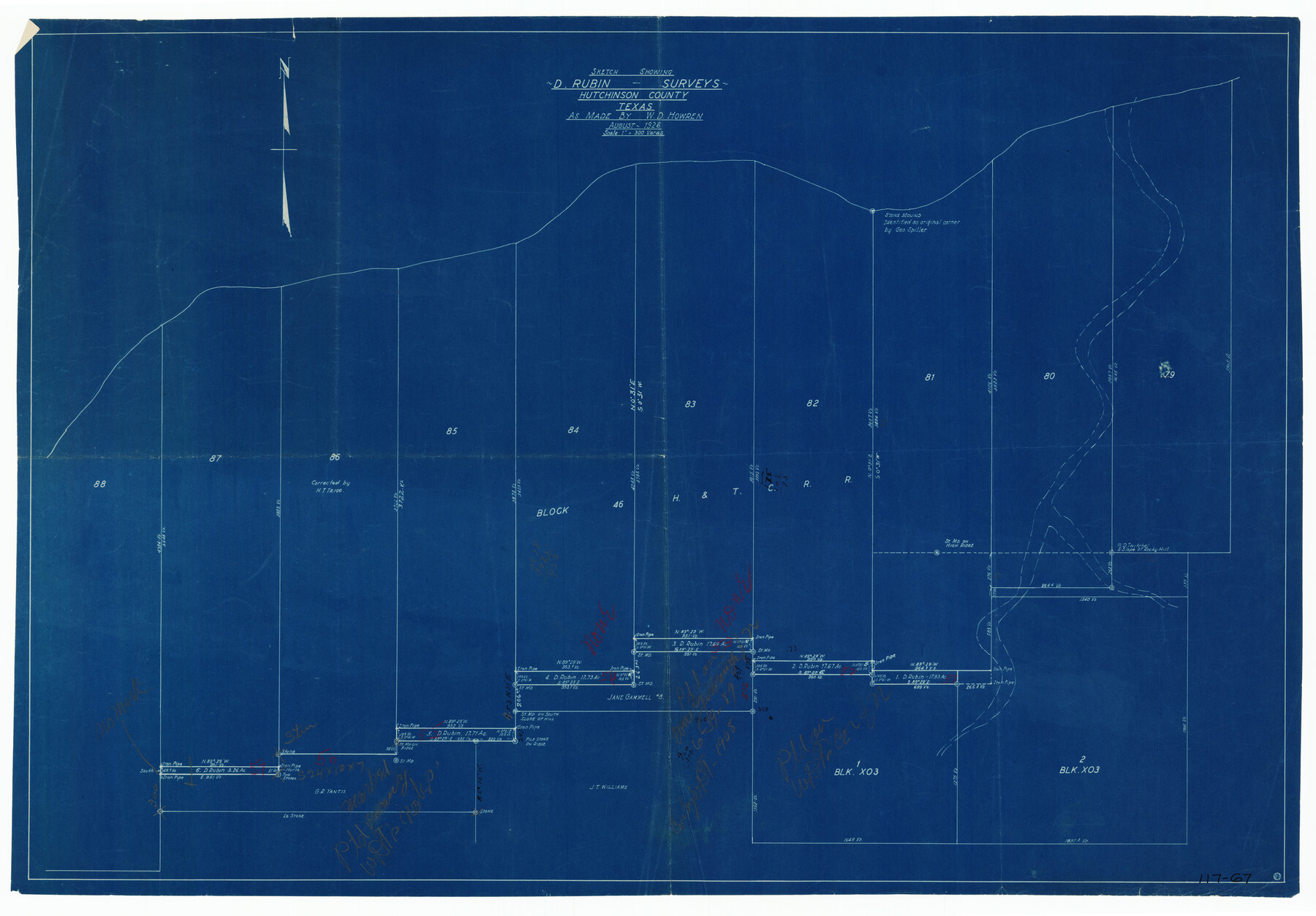
Sketch Showing D. Rubin Surveys
117-67
-
Map/Doc
91165
-
Collection
Twichell Survey Records
-
Object Dates
8/1926 (Creation Date)
-
People and Organizations
W.D. Howren (Surveyor/Engineer)
-
Counties
Hutchinson
-
Height x Width
35.1 x 24.5 inches
89.2 x 62.2 cm
Part of: Twichell Survey Records
[Township 3 North, Blocks 33 and 34, T. & P. RR. Company; Township 4 North, Block 33, T. & P. RR. Company]
![92564, [Township 3 North, Blocks 33 and 34, T. & P. RR. Company; Township 4 North, Block 33, T. & P. RR. Company], Twichell Survey Records](https://historictexasmaps.com/wmedia_w700/maps/92564-1.tif.jpg)
Print $20.00
- Digital $50.00
[Township 3 North, Blocks 33 and 34, T. & P. RR. Company; Township 4 North, Block 33, T. & P. RR. Company]
1911
Size 18.6 x 24.8 inches
Map/Doc 92564
[Working Sketch Showing Southwest Part of the County]
![91117, [Working Sketch Showing Southwest Part of the County], Twichell Survey Records](https://historictexasmaps.com/wmedia_w700/maps/91117-1.tif.jpg)
Print $2.00
- Digital $50.00
[Working Sketch Showing Southwest Part of the County]
1886
Size 14.9 x 9.0 inches
Map/Doc 91117
[Townships 1, 2, 3, Blocks, 62, 61, 60, 59, 58, 57, 56]
![92884, [Townships 1, 2, 3, Blocks, 62, 61, 60, 59, 58, 57, 56], Twichell Survey Records](https://historictexasmaps.com/wmedia_w700/maps/92884-1.tif.jpg)
Print $20.00
- Digital $50.00
[Townships 1, 2, 3, Blocks, 62, 61, 60, 59, 58, 57, 56]
1885
Size 19.1 x 10.3 inches
Map/Doc 92884
[SE/4 of NW/4 of King Co.]
![89925, [SE/4 of NW/4 of King Co.], Twichell Survey Records](https://historictexasmaps.com/wmedia_w700/maps/89925-1.tif.jpg)
Print $40.00
- Digital $50.00
[SE/4 of NW/4 of King Co.]
Size 43.7 x 55.5 inches
Map/Doc 89925
Map Showing Corrections of Capitol Leagues in Conflict in Oldham Co.

Print $40.00
- Digital $50.00
Map Showing Corrections of Capitol Leagues in Conflict in Oldham Co.
1886
Size 52.5 x 31.3 inches
Map/Doc 89800
Plat of 83.94 acre vacant tract of land showing connections to adjoining surveys

Print $20.00
- Digital $50.00
Plat of 83.94 acre vacant tract of land showing connections to adjoining surveys
1918
Size 17.7 x 21.1 inches
Map/Doc 90823
[Sections 158-162 and surveys to the east]
![93003, [Sections 158-162 and surveys to the east], Twichell Survey Records](https://historictexasmaps.com/wmedia_w700/maps/93003-1.tif.jpg)
Print $20.00
- Digital $50.00
[Sections 158-162 and surveys to the east]
1916
Size 7.8 x 18.9 inches
Map/Doc 93003
[E. L. & R.R. Block 1, G. C. & S. F. Blocks 1 & 2, T. R. R. Block 4]
![91280, [E. L. & R.R. Block 1, G. C. & S. F. Blocks 1 & 2, T. R. R. Block 4], Twichell Survey Records](https://historictexasmaps.com/wmedia_w700/maps/91280-1.tif.jpg)
Print $20.00
- Digital $50.00
[E. L. & R.R. Block 1, G. C. & S. F. Blocks 1 & 2, T. R. R. Block 4]
Size 8.7 x 19.3 inches
Map/Doc 91280
[John S. Stephens Blk. S2, Lgs. 174-177, 186-193, 201-209]
![89984, [John S. Stephens Blk. S2, Lgs. 174-177, 186-193, 201-209], Twichell Survey Records](https://historictexasmaps.com/wmedia_w700/maps/89984-1.tif.jpg)
Print $2.00
- Digital $50.00
[John S. Stephens Blk. S2, Lgs. 174-177, 186-193, 201-209]
1912
Size 11.4 x 8.8 inches
Map/Doc 89984
Roberts & McWhorter Addition

Print $20.00
- Digital $50.00
Roberts & McWhorter Addition
Size 31.0 x 30.6 inches
Map/Doc 93219
[East Neches River]
![90420, [East Neches River], Twichell Survey Records](https://historictexasmaps.com/wmedia_w700/maps/90420-1.tif.jpg)
Print $20.00
- Digital $50.00
[East Neches River]
Size 25.8 x 29.3 inches
Map/Doc 90420
Anton Independent School District Hockley and Lamb Counties, Texas

Print $20.00
- Digital $50.00
Anton Independent School District Hockley and Lamb Counties, Texas
Size 19.3 x 23.7 inches
Map/Doc 92215
You may also like
Kleberg County Rolled Sketch 11

Print $20.00
- Digital $50.00
Kleberg County Rolled Sketch 11
1915
Size 21.0 x 26.5 inches
Map/Doc 6552
Red River County Working Sketch 70

Print $20.00
- Digital $50.00
Red River County Working Sketch 70
1977
Size 22.6 x 24.0 inches
Map/Doc 72053
Map showing the John B. Pier Survey, Near Houston

Print $3.00
- Digital $50.00
Map showing the John B. Pier Survey, Near Houston
Size 11.9 x 17.8 inches
Map/Doc 478
Webb County Working Sketch 10

Print $20.00
- Digital $50.00
Webb County Working Sketch 10
1913
Size 23.7 x 20.0 inches
Map/Doc 72375
Plan C, Part 3rd This plan represents that portion of the boundary between the Republic of Texas and the United States included between the 72nd mile mound and Red River

Print $20.00
- Digital $50.00
Plan C, Part 3rd This plan represents that portion of the boundary between the Republic of Texas and the United States included between the 72nd mile mound and Red River
1842
Size 19.3 x 27.2 inches
Map/Doc 65414
English Field Notes of the Spanish Archives - Books TJG, DB, A, A2, B, B2, WB, and WR

English Field Notes of the Spanish Archives - Books TJG, DB, A, A2, B, B2, WB, and WR
1835
Map/Doc 96553
Flight Mission No. CRC-4R, Frame 105, Chambers County

Print $20.00
- Digital $50.00
Flight Mission No. CRC-4R, Frame 105, Chambers County
1956
Size 18.8 x 22.4 inches
Map/Doc 84902
Kimble County Working Sketch 90

Print $20.00
- Digital $50.00
Kimble County Working Sketch 90
1979
Size 17.3 x 28.2 inches
Map/Doc 70158
Flight Mission No. DQN-1K, Frame 152, Calhoun County

Print $20.00
- Digital $50.00
Flight Mission No. DQN-1K, Frame 152, Calhoun County
1953
Size 18.6 x 22.3 inches
Map/Doc 84211
General Highway Map, Zapata County, Texas

Print $20.00
General Highway Map, Zapata County, Texas
1961
Size 18.0 x 24.7 inches
Map/Doc 79722

Edwards County Working Sketch 39

Print $20.00
- Digital $50.00
Edwards County Working Sketch 39
1948
Size 28.7 x 32.3 inches
Map/Doc 68915