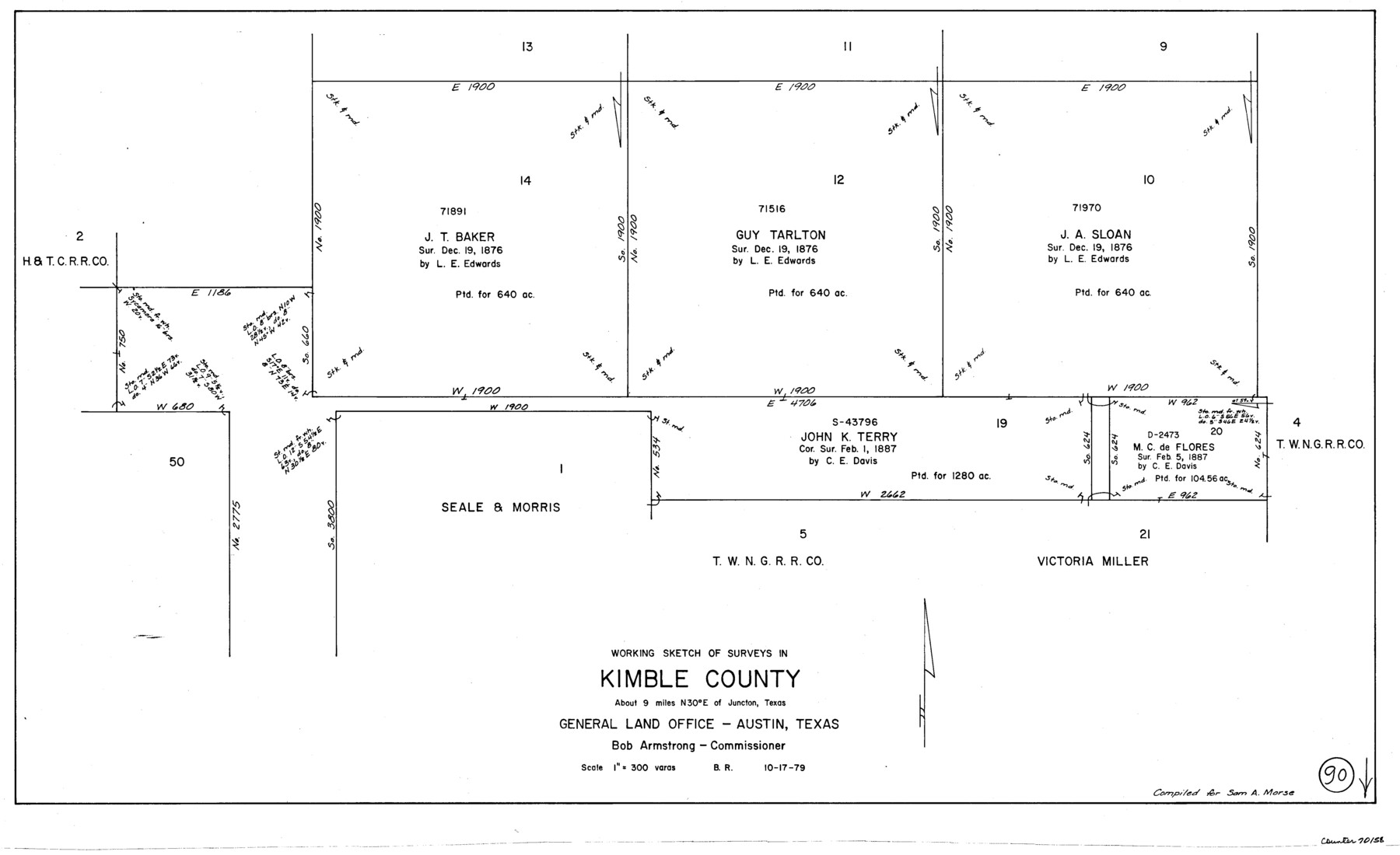
Kimble County Working Sketch 90
-
Map/Doc
70158
-
Collection
General Map Collection
-
Object Dates
10/17/1979 (Creation Date)
-
People and Organizations
Beverly Robison (Draftsman)
-
Counties
Kimble
-
Subjects
Surveying Working Sketch
-
Height x Width
17.3 x 28.2 inches
43.9 x 71.6 cm
-
Scale
1" = 300 varas
Part of: General Map Collection
Flight Mission No. DCL-7C, Frame 108, Kenedy County

Print $20.00
- Digital $50.00
Flight Mission No. DCL-7C, Frame 108, Kenedy County
1943
Size 18.3 x 22.2 inches
Map/Doc 86073

Kleberg County Rolled Sketch 10-36

Print $20.00
- Digital $50.00
Kleberg County Rolled Sketch 10-36
1952
Size 35.3 x 30.7 inches
Map/Doc 9382
Pecos County Rolled Sketch 133

Print $40.00
- Digital $50.00
Pecos County Rolled Sketch 133
1952
Size 50.8 x 12.1 inches
Map/Doc 9729
Childress County Rolled Sketch 9C

Print $20.00
- Digital $50.00
Childress County Rolled Sketch 9C
Size 13.8 x 17.9 inches
Map/Doc 5449
Hamilton County Working Sketch 35

Print $20.00
- Digital $50.00
Hamilton County Working Sketch 35
Size 26.3 x 19.1 inches
Map/Doc 78286
Mills County Sketch File 24

Print $20.00
- Digital $50.00
Mills County Sketch File 24
Size 19.2 x 21.0 inches
Map/Doc 12094
Map of Padre Island Showing Location of Zoning Districts

Print $20.00
- Digital $50.00
Map of Padre Island Showing Location of Zoning Districts
1971
Size 18.7 x 26.6 inches
Map/Doc 4808
Aransas County Rolled Sketch 1

Print $40.00
- Digital $50.00
Aransas County Rolled Sketch 1
1930
Size 54.3 x 17.0 inches
Map/Doc 8914
Val Verde County Sketch File 53

Print $20.00
- Digital $50.00
Val Verde County Sketch File 53
1892
Size 45.0 x 16.2 inches
Map/Doc 10421
Map of Bastrop District

Print $20.00
- Digital $50.00
Map of Bastrop District
1847
Size 22.9 x 28.3 inches
Map/Doc 3275
Van Zandt County Sketch File 33

Print $8.00
- Digital $50.00
Van Zandt County Sketch File 33
1860
Size 12.4 x 7.8 inches
Map/Doc 39469
You may also like
Travis County Working Sketch 43

Print $20.00
- Digital $50.00
Travis County Working Sketch 43
1974
Size 24.1 x 24.6 inches
Map/Doc 69427
Map of Part of Texas Prison System, Blue Ridge State Farm near Camp No. 1 Showing Buildings and Property Lines

Print $20.00
- Digital $50.00
Map of Part of Texas Prison System, Blue Ridge State Farm near Camp No. 1 Showing Buildings and Property Lines
Size 20.3 x 25.4 inches
Map/Doc 62980
Kenedy County Rolled Sketch 11

Print $20.00
- Digital $50.00
Kenedy County Rolled Sketch 11
1938
Size 40.5 x 30.2 inches
Map/Doc 6471
El Paso County Working Sketch 42

Print $20.00
- Digital $50.00
El Paso County Working Sketch 42
Size 24.6 x 26.6 inches
Map/Doc 69064
Erath County Sketch File 10a

Print $4.00
- Digital $50.00
Erath County Sketch File 10a
1871
Size 8.0 x 12.8 inches
Map/Doc 22277
Edwards County Sketch File 5

Print $5.00
- Digital $50.00
Edwards County Sketch File 5
Size 9.0 x 3.9 inches
Map/Doc 21682
Capitol Syndicate Subdivision of Capitol Land Reservation Leagues Number 153, 154, 155, 156, 157, 158, 167, 168, 169, 170, 171, and 172 and Parts of Leagues 143, 144, 145, 146, 152, 159, 166, and 173

Print $20.00
- Digital $50.00
Capitol Syndicate Subdivision of Capitol Land Reservation Leagues Number 153, 154, 155, 156, 157, 158, 167, 168, 169, 170, 171, and 172 and Parts of Leagues 143, 144, 145, 146, 152, 159, 166, and 173
1908
Size 22.8 x 34.6 inches
Map/Doc 90735
Hemphill County Rolled Sketch 4

Print $40.00
- Digital $50.00
Hemphill County Rolled Sketch 4
Size 29.7 x 55.1 inches
Map/Doc 6186
Bailey County Rolled Sketch RSH

Print $20.00
- Digital $50.00
Bailey County Rolled Sketch RSH
1907
Size 34.3 x 23.3 inches
Map/Doc 5112
Palo Pinto County Sketch File 27

Print $21.00
- Digital $50.00
Palo Pinto County Sketch File 27
1875
Size 9.8 x 15.7 inches
Map/Doc 33430
Rand McNally Standard Map of Texas

Print $20.00
- Digital $50.00
Rand McNally Standard Map of Texas
1921
Size 27.7 x 40.4 inches
Map/Doc 95853
Navarro County Sketch File 18

Print $3.00
- Digital $50.00
Navarro County Sketch File 18
1871
Size 10.6 x 10.0 inches
Map/Doc 32335