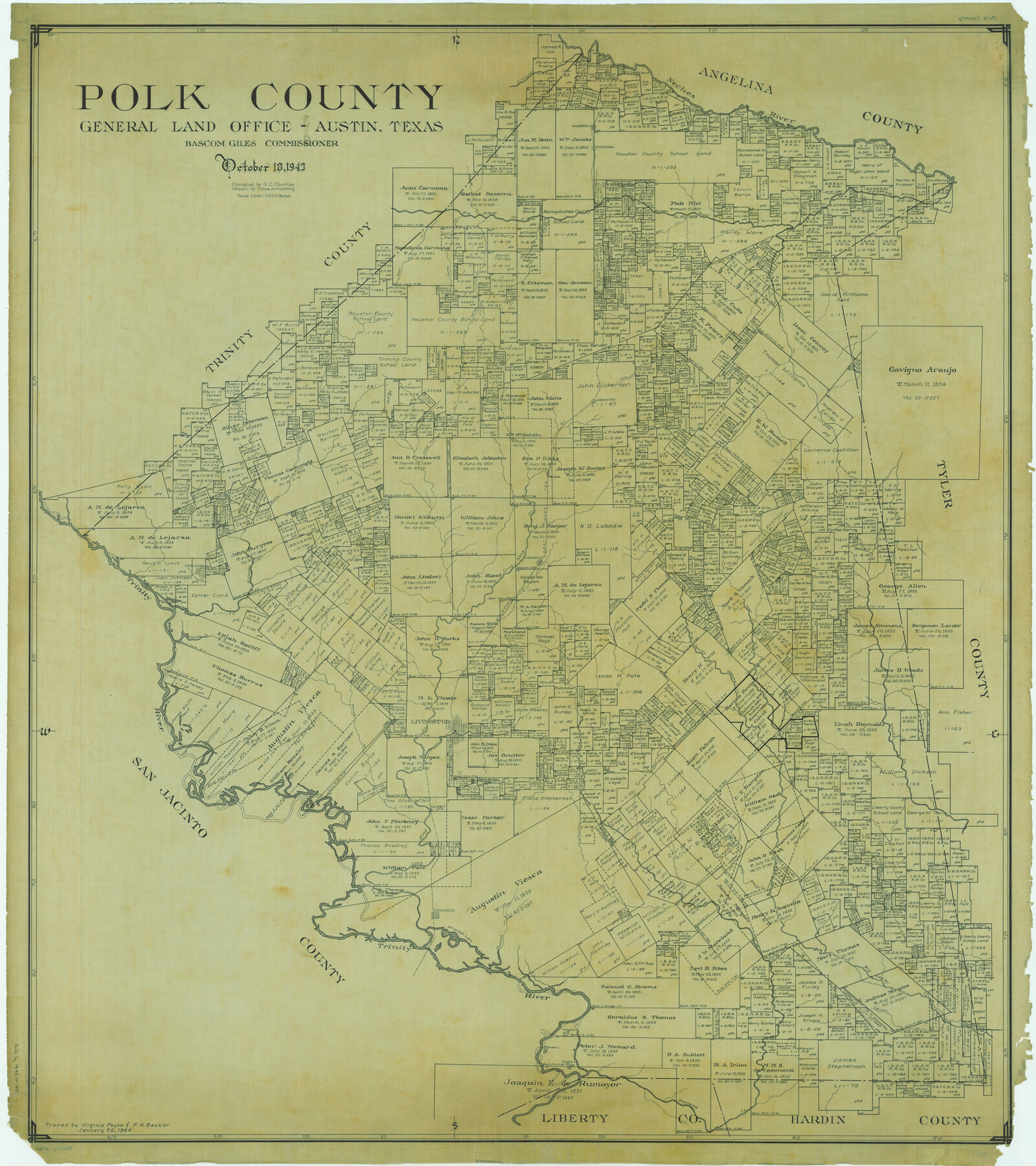
Polk County
-
Map/Doc
66982
-
Collection
General Map Collection
-
Object Dates
1943/10/18 (Creation Date)
-
People and Organizations
Texas General Land Office (Publisher)
Bascom Giles (GLO Commissioner)
Eltea Armstrong (Draftsman)
G.C. Morriss (Compiler)
-
Counties
Polk
-
Subjects
County
-
Height x Width
48.4 x 43.0 inches
122.9 x 109.2 cm
-
Comments
Traced January 26, 1944 by Virginia Payne and F. H. Becker.
Part of: General Map Collection
Flight Mission No. CRC-6R, Frame 13, Chambers County

Print $20.00
- Digital $50.00
Flight Mission No. CRC-6R, Frame 13, Chambers County
1956
Size 18.6 x 22.3 inches
Map/Doc 84967
Hall County Sketch File 8

Print $20.00
- Digital $50.00
Hall County Sketch File 8
Size 12.8 x 23.1 inches
Map/Doc 11604
Dimmit County Working Sketch 16

Print $20.00
- Digital $50.00
Dimmit County Working Sketch 16
1943
Size 25.6 x 24.8 inches
Map/Doc 68677
Yoakum County Sketch File 6

Print $24.00
- Digital $50.00
Yoakum County Sketch File 6
Size 14.5 x 8.8 inches
Map/Doc 40738
Jeff Davis County Working Sketch 4

Print $20.00
- Digital $50.00
Jeff Davis County Working Sketch 4
1916
Size 14.3 x 15.2 inches
Map/Doc 66499
Louisiana and Texas Intracoastal Waterway

Print $20.00
- Digital $50.00
Louisiana and Texas Intracoastal Waterway
1929
Size 13.7 x 19.0 inches
Map/Doc 83344
Pecos County Rolled Sketch 110

Print $20.00
- Digital $50.00
Pecos County Rolled Sketch 110
Size 29.1 x 30.4 inches
Map/Doc 7255
Real County Working Sketch 81

Print $20.00
- Digital $50.00
Real County Working Sketch 81
1984
Size 19.9 x 17.1 inches
Map/Doc 71973
Clay County Boundary File 13

Print $48.00
- Digital $50.00
Clay County Boundary File 13
Size 10.6 x 9.1 inches
Map/Doc 51410
Mason County Working Sketch 23

Print $20.00
- Digital $50.00
Mason County Working Sketch 23
2004
Size 17.4 x 36.9 inches
Map/Doc 83577
San Patricio County NRC Article 33.136 Sketch 4

Print $3.00
- Digital $50.00
San Patricio County NRC Article 33.136 Sketch 4
Size 11.0 x 17.0 inches
Map/Doc 94695
Map of Hale County

Print $40.00
- Digital $50.00
Map of Hale County
1900
Size 49.3 x 41.0 inches
Map/Doc 4691
You may also like
Loving County Rolled Sketch 10

Print $20.00
- Digital $50.00
Loving County Rolled Sketch 10
1990
Size 32.0 x 43.6 inches
Map/Doc 9468
Travis County Rolled Sketch 7

Print $20.00
- Digital $50.00
Travis County Rolled Sketch 7
Size 17.4 x 37.0 inches
Map/Doc 8012
General Road Map, Webb County, Texas

Print $40.00
- Digital $50.00
General Road Map, Webb County, Texas
1944
Size 37.1 x 50.0 inches
Map/Doc 10126
Pecos County Working Sketch 55

Print $20.00
- Digital $50.00
Pecos County Working Sketch 55
1948
Size 38.4 x 27.7 inches
Map/Doc 71527
[PSL Blocks A6-A12]
![89780, [PSL Blocks A6-A12], Twichell Survey Records](https://historictexasmaps.com/wmedia_w700/maps/89780-1.tif.jpg)
Print $40.00
- Digital $50.00
[PSL Blocks A6-A12]
Size 23.2 x 64.7 inches
Map/Doc 89780
Nacogdoches County Sketch File 11

Print $2.00
- Digital $50.00
Nacogdoches County Sketch File 11
Size 8.0 x 8.8 inches
Map/Doc 32255
Lamb County Rolled Sketch 2

Print $20.00
- Digital $50.00
Lamb County Rolled Sketch 2
1917
Size 37.9 x 43.4 inches
Map/Doc 9412
San Patricio County Sketch File 38

Print $112.00
- Digital $50.00
San Patricio County Sketch File 38
Size 7.9 x 7.3 inches
Map/Doc 36176
Jefferson County Working Sketch 42

Print $20.00
- Digital $50.00
Jefferson County Working Sketch 42
1996
Size 31.7 x 47.2 inches
Map/Doc 66586
Sutton County Sketch File 23

Print $30.00
- Digital $50.00
Sutton County Sketch File 23
1918
Size 14.2 x 8.5 inches
Map/Doc 37461
Pecos County Rolled Sketch 125

Print $20.00
- Digital $50.00
Pecos County Rolled Sketch 125
1948
Size 32.0 x 41.6 inches
Map/Doc 7266
Hemphill County Sketch File 2

Print $8.00
- Digital $50.00
Hemphill County Sketch File 2
1900
Size 10.3 x 8.4 inches
Map/Doc 26281