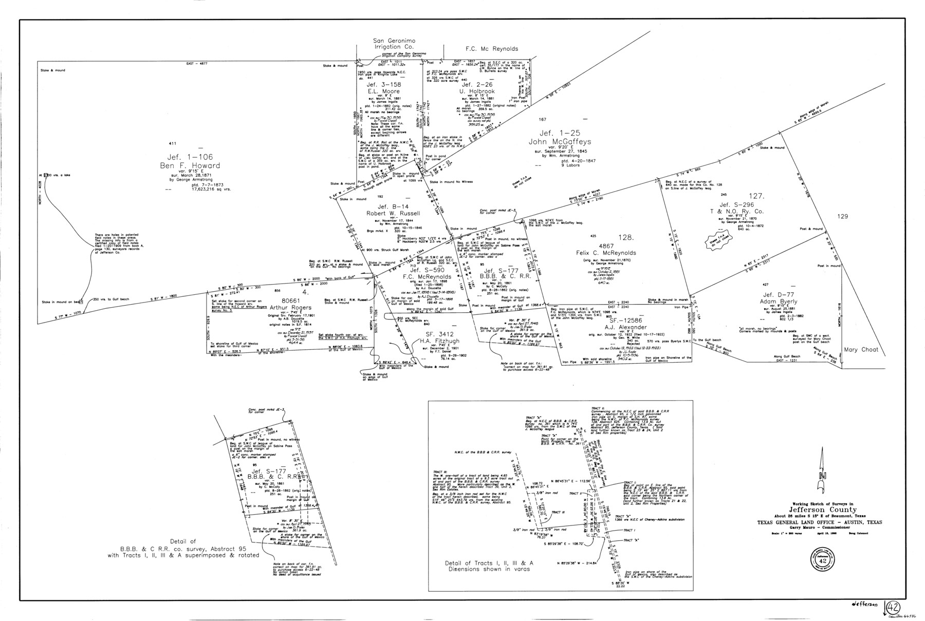
Jefferson County Working Sketch 42
-
Map/Doc
66586
-
Collection
General Map Collection
-
Object Dates
4/15/1996 (Creation Date)
-
People and Organizations
Doug Catenaci (Draftsman)
-
Counties
Jefferson
-
Subjects
Surveying Working Sketch
-
Height x Width
31.7 x 47.2 inches
80.5 x 119.9 cm
-
Scale
1" = 300 varas
Part of: General Map Collection
Jasper County Working Sketch 22

Print $20.00
- Digital $50.00
Jasper County Working Sketch 22
1943
Size 21.0 x 15.4 inches
Map/Doc 66484
Flight Mission No. CRK-5P, Frame 161, Refugio County

Print $20.00
- Digital $50.00
Flight Mission No. CRK-5P, Frame 161, Refugio County
1956
Size 18.5 x 22.4 inches
Map/Doc 86942
Chambers County Working Sketch 19

Print $20.00
- Digital $50.00
Chambers County Working Sketch 19
1965
Size 23.5 x 25.8 inches
Map/Doc 68002
Map of Maverick County

Print $20.00
- Digital $50.00
Map of Maverick County
1874
Size 31.5 x 20.9 inches
Map/Doc 3848
Flight Mission No. CRE-1R, Frame 132, Jackson County

Print $20.00
- Digital $50.00
Flight Mission No. CRE-1R, Frame 132, Jackson County
1956
Size 16.2 x 16.0 inches
Map/Doc 85340
Duval County Working Sketch 51

Print $20.00
- Digital $50.00
Duval County Working Sketch 51
1986
Size 27.3 x 35.3 inches
Map/Doc 68775
Travis County Working Sketch 45

Print $20.00
- Digital $50.00
Travis County Working Sketch 45
1975
Size 33.6 x 28.7 inches
Map/Doc 69429
Flight Mission No. DCL-7C, Frame 4, Kenedy County

Print $20.00
- Digital $50.00
Flight Mission No. DCL-7C, Frame 4, Kenedy County
1943
Size 18.6 x 22.3 inches
Map/Doc 85996
Duval County Working Sketch 40

Print $20.00
- Digital $50.00
Duval County Working Sketch 40
1960
Size 19.5 x 16.6 inches
Map/Doc 68764
Kendall County Working Sketch Graphic Index

Print $20.00
- Digital $50.00
Kendall County Working Sketch Graphic Index
1946
Size 40.3 x 34.8 inches
Map/Doc 76602

[Surveys along Bosque and Hog Creek]
![238, [Surveys along Bosque and Hog Creek], General Map Collection](https://historictexasmaps.com/wmedia_w700/maps/238.tif.jpg)
Print $20.00
- Digital $50.00
[Surveys along Bosque and Hog Creek]
1845
Size 23.9 x 17.0 inches
Map/Doc 238
You may also like
Johnson County Sketch File 5

Print $20.00
- Digital $50.00
Johnson County Sketch File 5
1874
Size 33.3 x 14.3 inches
Map/Doc 11890
San Jacinto County

Print $40.00
- Digital $50.00
San Jacinto County
1942
Size 49.7 x 44.1 inches
Map/Doc 95633
Shackelford County Working Sketch 3

Print $20.00
- Digital $50.00
Shackelford County Working Sketch 3
1919
Size 23.2 x 17.5 inches
Map/Doc 63843
Coleman County Sketch File 4

Print $2.00
- Digital $50.00
Coleman County Sketch File 4
1855
Size 8.2 x 8.8 inches
Map/Doc 18672
[Surveys Surrounding I. G. Yates S.F. 12394]
![91560, [Surveys Surrounding I. G. Yates S.F. 12394], Twichell Survey Records](https://historictexasmaps.com/wmedia_w700/maps/91560-1.tif.jpg)
Print $20.00
- Digital $50.00
[Surveys Surrounding I. G. Yates S.F. 12394]
Size 18.6 x 7.4 inches
Map/Doc 91560
Henderson County Working Sketch 20

Print $20.00
- Digital $50.00
Henderson County Working Sketch 20
1947
Size 31.6 x 18.9 inches
Map/Doc 66153
Brooks County Working Sketch 17

Print $20.00
- Digital $50.00
Brooks County Working Sketch 17
1980
Size 38.2 x 27.7 inches
Map/Doc 67801
Palo Pinto County

Print $20.00
- Digital $50.00
Palo Pinto County
Size 23.7 x 18.6 inches
Map/Doc 3936
Harrison County State Real Property Sketch 2

Print $20.00
- Digital $50.00
Harrison County State Real Property Sketch 2
1986
Size 23.9 x 25.0 inches
Map/Doc 61667
Presidio County Sketch File 49

Print $6.00
- Digital $50.00
Presidio County Sketch File 49
1919
Size 14.6 x 11.9 inches
Map/Doc 34584
Lampasas County Working Sketch 3

Print $20.00
- Digital $50.00
Lampasas County Working Sketch 3
1941
Size 25.0 x 14.6 inches
Map/Doc 70280
Township 4 North Range 13 West, North Western District, Louisiana

Print $20.00
- Digital $50.00
Township 4 North Range 13 West, North Western District, Louisiana
1884
Size 19.6 x 24.6 inches
Map/Doc 65866