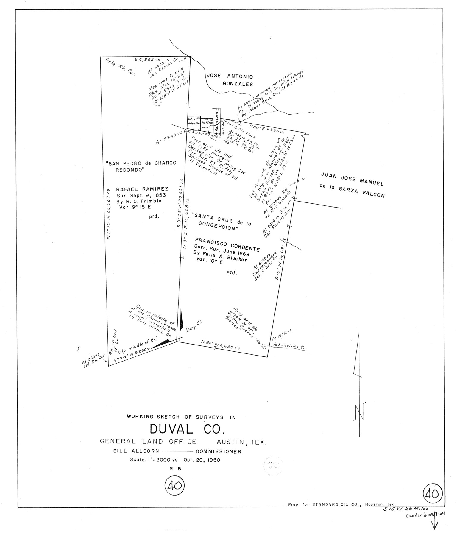
Duval County Working Sketch 40
-
Map/Doc
68764
-
Collection
General Map Collection
-
Object Dates
10/20/1960 (Creation Date)
-
People and Organizations
Roy Buckholts (Draftsman)
-
Counties
Duval
-
Subjects
Surveying Working Sketch
-
Height x Width
19.5 x 16.6 inches
49.5 x 42.2 cm
-
Scale
1" = 2000 varas
Part of: General Map Collection
Duval County Rolled Sketch 38

Print $20.00
- Digital $50.00
Duval County Rolled Sketch 38
1937
Size 22.6 x 16.1 inches
Map/Doc 5755
Newton County Sketch File 4

Print $22.00
- Digital $50.00
Newton County Sketch File 4
1876
Size 8.0 x 12.8 inches
Map/Doc 32360
Aransas County Rolled Sketch 18

Print $29.00
- Digital $50.00
Aransas County Rolled Sketch 18
1965
Size 11.0 x 15.1 inches
Map/Doc 42328
Kendall County Sketch File 11

Print $8.00
- Digital $50.00
Kendall County Sketch File 11
1924
Size 11.2 x 8.7 inches
Map/Doc 28695
Bandera County Boundary File 4

Print $18.00
- Digital $50.00
Bandera County Boundary File 4
Size 8.9 x 7.7 inches
Map/Doc 50267
Brown County Rolled Sketch 2B

Print $20.00
- Digital $50.00
Brown County Rolled Sketch 2B
1984
Size 24.3 x 18.6 inches
Map/Doc 5351
Coleman County Sketch File 26a

Print $3.00
- Digital $50.00
Coleman County Sketch File 26a
Size 10.6 x 15.8 inches
Map/Doc 11120
Hartley County Working Sketch 5

Print $20.00
- Digital $50.00
Hartley County Working Sketch 5
1957
Size 46.3 x 28.9 inches
Map/Doc 66055
Brown County Sketch File 2

Print $4.00
- Digital $50.00
Brown County Sketch File 2
Size 11.8 x 8.1 inches
Map/Doc 16582
Nueces County Rolled Sketch 100

Print $20.00
- Digital $50.00
Nueces County Rolled Sketch 100
Size 21.3 x 32.7 inches
Map/Doc 10697
North Shore of West Bay and Galveston Island

Print $40.00
- Digital $50.00
North Shore of West Bay and Galveston Island
1933
Size 36.4 x 56.9 inches
Map/Doc 69931
Cottle County Working Sketch 11

Print $20.00
- Digital $50.00
Cottle County Working Sketch 11
1943
Size 19.2 x 24.1 inches
Map/Doc 68321
You may also like
Ward County Sketch File 6

Print $20.00
- Digital $50.00
Ward County Sketch File 6
Size 21.6 x 45.5 inches
Map/Doc 10427
Flight Mission No. DQO-1K, Frame 149, Galveston County

Print $20.00
- Digital $50.00
Flight Mission No. DQO-1K, Frame 149, Galveston County
1952
Size 19.0 x 22.8 inches
Map/Doc 85002
McCulloch County Sketch File 13

Print $4.00
- Digital $50.00
McCulloch County Sketch File 13
1982
Size 3.4 x 7.8 inches
Map/Doc 31201
[Block Y and vicinity]
![91177, [Block Y and vicinity], Twichell Survey Records](https://historictexasmaps.com/wmedia_w700/maps/91177-1.tif.jpg)
Print $20.00
- Digital $50.00
[Block Y and vicinity]
Size 17.7 x 14.6 inches
Map/Doc 91177
Supreme Court of the United States, October Term, 1923, No. 15, Original - The State of Oklahoma, Complainant vs. The State of Texas, Defendant, The United States, Intervener; Report of the Boundary Commissioners

Print $20.00
- Digital $50.00
Supreme Court of the United States, October Term, 1923, No. 15, Original - The State of Oklahoma, Complainant vs. The State of Texas, Defendant, The United States, Intervener; Report of the Boundary Commissioners
1923
Size 46.4 x 33.4 inches
Map/Doc 75122

Hansford County Boundary File 2

Print $14.00
- Digital $50.00
Hansford County Boundary File 2
Size 9.3 x 4.9 inches
Map/Doc 54245
Flight Mission No. CGI-3N, Frame 136, Cameron County

Print $20.00
- Digital $50.00
Flight Mission No. CGI-3N, Frame 136, Cameron County
1954
Size 18.6 x 22.3 inches
Map/Doc 84609
Brewster County Rolled Sketch B

Print $40.00
- Digital $50.00
Brewster County Rolled Sketch B
1882
Size 67.4 x 37.7 inches
Map/Doc 8465
Upton County Working Sketch 59

Print $20.00
- Digital $50.00
Upton County Working Sketch 59
1987
Size 21.5 x 34.3 inches
Map/Doc 69556
Hopkins County Rolled Sketch 1

Print $20.00
- Digital $50.00
Hopkins County Rolled Sketch 1
Size 34.5 x 40.0 inches
Map/Doc 6224
Denton County Working Sketch 3

Print $20.00
- Digital $50.00
Denton County Working Sketch 3
1935
Size 24.6 x 36.4 inches
Map/Doc 68608