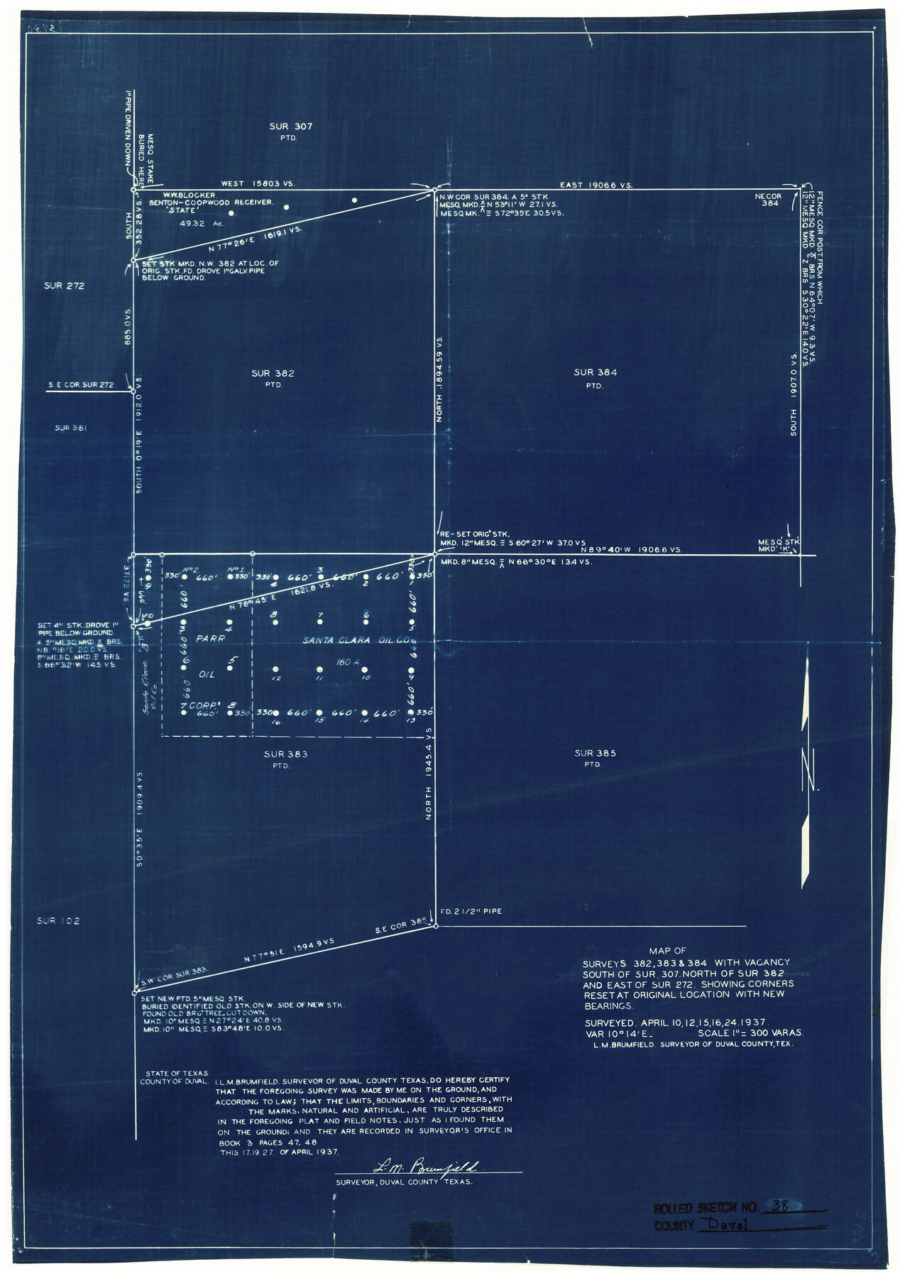
Duval County Rolled Sketch 38
Map of surveys 382, 383 & 384 with vacancy south of sur. 307, north of sur. 382 and east of sur. 272 showing corners reset at original location with new bearings
-
Map/Doc
5755
-
Collection
General Map Collection
-
Object Dates
4/27/1937 (Creation Date)
5/25/1956 (File Date)
-
People and Organizations
L.M. Brumfield (Surveyor/Engineer)
-
Counties
Duval
-
Subjects
Surveying Rolled Sketch
-
Height x Width
22.6 x 16.1 inches
57.4 x 40.9 cm
-
Medium
blueprint/diazo
-
Scale
1" = 300 varas
Part of: General Map Collection
Sutton County Sketch File 58

Print $9.00
- Digital $50.00
Sutton County Sketch File 58
1964
Size 15.7 x 9.9 inches
Map/Doc 37554
Map of the United States, Canada and a part of Mexico to illustrate Olney's school geography

Print $20.00
- Digital $50.00
Map of the United States, Canada and a part of Mexico to illustrate Olney's school geography
1844
Size 12.1 x 19.0 inches
Map/Doc 93537
Lynn County Boundary File 2

Print $6.00
- Digital $50.00
Lynn County Boundary File 2
Size 11.1 x 8.7 inches
Map/Doc 56620
Wichita County Working Sketch 20

Print $20.00
- Digital $50.00
Wichita County Working Sketch 20
1950
Size 33.2 x 23.0 inches
Map/Doc 72530
Galveston County Rolled Sketch 8

Print $20.00
- Digital $50.00
Galveston County Rolled Sketch 8
Size 24.3 x 34.8 inches
Map/Doc 5951
Atascosa County Sketch File 36

Print $20.00
- Digital $50.00
Atascosa County Sketch File 36
1947
Size 16.0 x 22.3 inches
Map/Doc 10867
Live Oak County Rolled Sketch 1

Print $20.00
- Digital $50.00
Live Oak County Rolled Sketch 1
1943
Size 25.6 x 42.4 inches
Map/Doc 6631
Angelina County Working Sketch 14

Print $20.00
- Digital $50.00
Angelina County Working Sketch 14
1935
Size 29.6 x 34.9 inches
Map/Doc 67095
Houston County Sketch File 14

Print $6.00
- Digital $50.00
Houston County Sketch File 14
1886
Size 8.8 x 13.0 inches
Map/Doc 26778
Kendall County Boundary File 2a

Print $12.00
- Digital $50.00
Kendall County Boundary File 2a
Size 10.0 x 7.9 inches
Map/Doc 55748
Dickens County Working Sketch 6

Print $20.00
- Digital $50.00
Dickens County Working Sketch 6
1932
Size 23.7 x 30.7 inches
Map/Doc 68654
Flight Mission No. DCL-6C, Frame 21, Kenedy County

Print $20.00
- Digital $50.00
Flight Mission No. DCL-6C, Frame 21, Kenedy County
1943
Size 18.7 x 22.5 inches
Map/Doc 85878
You may also like
[Showing west and north line of County]
![90652, [Showing west and north line of County], Twichell Survey Records](https://historictexasmaps.com/wmedia_w700/maps/90652-1.tif.jpg)
Print $20.00
- Digital $50.00
[Showing west and north line of County]
1885
Size 21.3 x 29.0 inches
Map/Doc 90652
Gonzales County Sketch File 12

Print $4.00
- Digital $50.00
Gonzales County Sketch File 12
Size 10.8 x 8.7 inches
Map/Doc 24394
Cameron County Rolled Sketch 20A

Print $20.00
- Digital $50.00
Cameron County Rolled Sketch 20A
Size 12.5 x 23.1 inches
Map/Doc 5471
Flight Mission No. BQR-16K, Frame 37, Brazoria County

Print $20.00
- Digital $50.00
Flight Mission No. BQR-16K, Frame 37, Brazoria County
1952
Size 18.6 x 22.3 inches
Map/Doc 84104
Kent County Working Sketch 25

Print $20.00
- Digital $50.00
Kent County Working Sketch 25
1989
Size 18.8 x 18.5 inches
Map/Doc 69641
Duval County Working Sketch 15

Print $20.00
- Digital $50.00
Duval County Working Sketch 15
1938
Size 23.3 x 22.7 inches
Map/Doc 68728
Duval County Rolled Sketch 43

Print $20.00
- Digital $50.00
Duval County Rolled Sketch 43
1981
Size 44.3 x 34.7 inches
Map/Doc 8820
Hopkins County Sketch File 2a

Print $4.00
- Digital $50.00
Hopkins County Sketch File 2a
Size 13.6 x 8.6 inches
Map/Doc 26683
Map of Archer County

Print $20.00
- Digital $50.00
Map of Archer County
1886
Size 24.4 x 20.5 inches
Map/Doc 3240
Clay County Working Sketch 2

Print $20.00
- Digital $50.00
Clay County Working Sketch 2
1907
Size 26.5 x 16.2 inches
Map/Doc 68025
Galveston County Working Sketch 15

Print $20.00
- Digital $50.00
Galveston County Working Sketch 15
1978
Size 32.0 x 27.8 inches
Map/Doc 69352
Coke County Rolled Sketch 14B

Print $20.00
- Digital $50.00
Coke County Rolled Sketch 14B
Size 16.3 x 19.3 inches
Map/Doc 5516