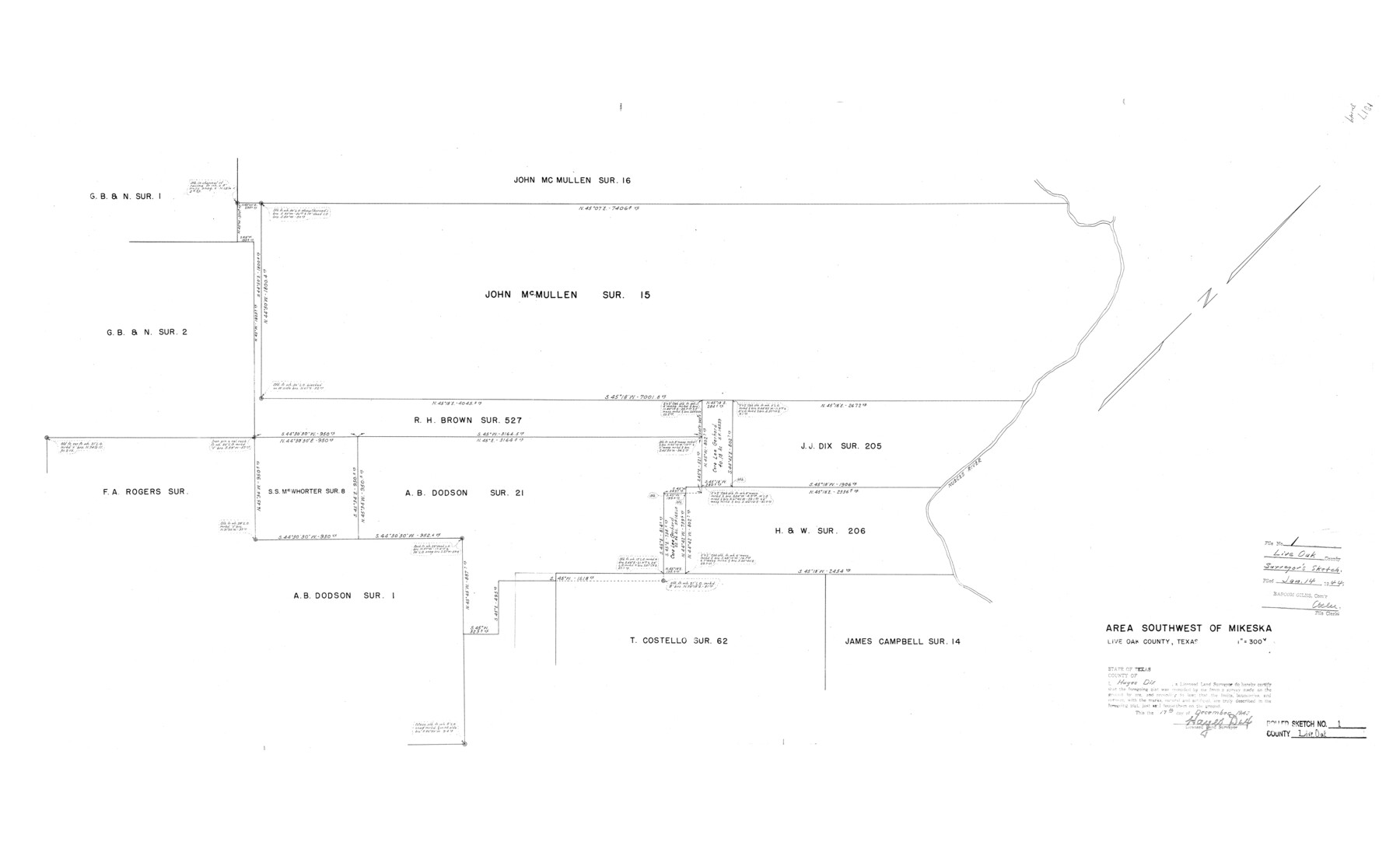
Live Oak County Rolled Sketch 1
Area southwest of Mikeska
-
Map/Doc
6631
-
Collection
General Map Collection
-
Object Dates
1943/12/17 (Creation Date)
1944/1/14 (File Date)
-
People and Organizations
Hayes Dix (Surveyor/Engineer)
-
Counties
Live Oak
-
Subjects
Surveying Rolled Sketch
-
Height x Width
25.6 x 42.4 inches
65.0 x 107.7 cm
-
Scale
1" = 300 varas
Part of: General Map Collection
Nacogdoches County Sketch File 11

Print $2.00
- Digital $50.00
Nacogdoches County Sketch File 11
Size 8.0 x 8.8 inches
Map/Doc 32255
Jefferson County Rolled Sketch 20

Print $60.00
- Digital $50.00
Jefferson County Rolled Sketch 20
1935
Size 29.2 x 36.2 inches
Map/Doc 9285
Culberson County Working Sketch 25

Print $40.00
- Digital $50.00
Culberson County Working Sketch 25
1951
Size 30.5 x 52.9 inches
Map/Doc 68478
Dallam County

Print $20.00
- Digital $50.00
Dallam County
1901
Size 42.3 x 52.4 inches
Map/Doc 16953
Presidio County Working Sketch 124

Print $20.00
- Digital $50.00
Presidio County Working Sketch 124
1984
Size 30.8 x 24.3 inches
Map/Doc 71802
Val Verde County Rolled Sketch 48

Print $20.00
- Digital $50.00
Val Verde County Rolled Sketch 48
Size 30.9 x 27.1 inches
Map/Doc 8119
Flight Mission No. DIX-8P, Frame 82, Aransas County

Print $20.00
- Digital $50.00
Flight Mission No. DIX-8P, Frame 82, Aransas County
1956
Size 18.6 x 22.4 inches
Map/Doc 83907
Supreme Court of the United States, October Term, 1923, No. 15, Original - The State of Oklahoma, Complainant vs. The State of Texas, Defendant, The United States, Intervener; Report of Medial Line Survey

Print $28.00
- Digital $50.00
Supreme Court of the United States, October Term, 1923, No. 15, Original - The State of Oklahoma, Complainant vs. The State of Texas, Defendant, The United States, Intervener; Report of Medial Line Survey
1924
Size 5.9 x 9.1 inches
Map/Doc 3055

Culberson County Working Sketch 30

Print $20.00
- Digital $50.00
Culberson County Working Sketch 30
1958
Size 29.3 x 30.2 inches
Map/Doc 68483
Harris County Sketch File 30

Print $21.00
- Digital $50.00
Harris County Sketch File 30
Size 11.3 x 8.5 inches
Map/Doc 25416
Wilson County Boundary File 5a

Print $20.00
- Digital $50.00
Wilson County Boundary File 5a
Size 12.0 x 28.0 inches
Map/Doc 60118
You may also like
Harris County Sketch File 84

Print $20.00
- Digital $50.00
Harris County Sketch File 84
1950
Size 23.1 x 35.7 inches
Map/Doc 11672
Val Verde County Sketch File Z13

Print $4.00
- Digital $50.00
Val Verde County Sketch File Z13
1898
Size 11.5 x 8.6 inches
Map/Doc 39142
Gomez Section 1, Block D-12

Print $20.00
- Digital $50.00
Gomez Section 1, Block D-12
1955
Size 15.8 x 16.8 inches
Map/Doc 92321
Dimmit County Working Sketch 2

Print $20.00
- Digital $50.00
Dimmit County Working Sketch 2
1906
Size 22.7 x 21.5 inches
Map/Doc 68663

Panola County Sketch File 26

Print $20.00
- Digital $50.00
Panola County Sketch File 26
1944
Size 28.5 x 27.1 inches
Map/Doc 12141
Dimmit County, Texas

Print $20.00
- Digital $50.00
Dimmit County, Texas
1879
Size 22.5 x 29.0 inches
Map/Doc 710

Flight Mission No. DAG-23K, Frame 178, Matagorda County

Print $20.00
- Digital $50.00
Flight Mission No. DAG-23K, Frame 178, Matagorda County
1953
Size 18.8 x 22.5 inches
Map/Doc 86513
Borden County Working Sketch 13

Print $20.00
- Digital $50.00
Borden County Working Sketch 13
1958
Size 24.1 x 35.6 inches
Map/Doc 67473
San Jacinto County Working Sketch 3

Print $20.00
- Digital $50.00
San Jacinto County Working Sketch 3
1926
Size 16.7 x 19.7 inches
Map/Doc 63716
Howard County

Print $20.00
- Digital $50.00
Howard County
1922
Size 40.3 x 34.6 inches
Map/Doc 77318