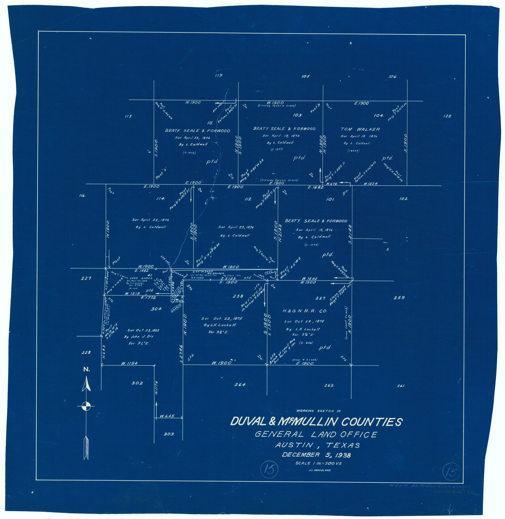
Duval County Working Sketch 15
-
Map/Doc
68728
-
Collection
General Map Collection
-
Object Dates
12/5/1938 (Creation Date)
-
People and Organizations
J.L. Woodland (Draftsman)
-
Counties
Duval McMullen
-
Subjects
Surveying Working Sketch
-
Height x Width
23.3 x 22.7 inches
59.2 x 57.7 cm
-
Scale
1" = 500 varas
Part of: General Map Collection
Kerr County Working Sketch 22

Print $40.00
- Digital $50.00
Kerr County Working Sketch 22
1965
Size 50.9 x 40.4 inches
Map/Doc 70053
Right-of-Way and Track Map, Texas State Railroad operated by the T. and N. O. R.R. Co.

Print $40.00
- Digital $50.00
Right-of-Way and Track Map, Texas State Railroad operated by the T. and N. O. R.R. Co.
1917
Size 24.3 x 55.7 inches
Map/Doc 64176
Blanco County Working Sketch 14

Print $20.00
- Digital $50.00
Blanco County Working Sketch 14
1948
Size 36.2 x 28.8 inches
Map/Doc 67374
Coryell County Sketch File 16

Print $4.00
- Digital $50.00
Coryell County Sketch File 16
Size 6.5 x 5.4 inches
Map/Doc 19373
Edwards County Working Sketch 78

Print $20.00
- Digital $50.00
Edwards County Working Sketch 78
1962
Size 26.5 x 22.1 inches
Map/Doc 68954
Travis County Working Sketch 63

Print $20.00
- Digital $50.00
Travis County Working Sketch 63
1998
Size 24.0 x 29.5 inches
Map/Doc 69447
McCulloch County Sketch File 8

Print $4.00
- Digital $50.00
McCulloch County Sketch File 8
1904
Size 11.3 x 8.7 inches
Map/Doc 31182
Ward County Working Sketch 41

Print $20.00
- Digital $50.00
Ward County Working Sketch 41
1969
Size 45.3 x 31.7 inches
Map/Doc 72347
Gregg County Sketch File 10

Print $20.00
- Digital $50.00
Gregg County Sketch File 10
1932
Size 35.1 x 26.0 inches
Map/Doc 11588
Colorado River, Brackenridge Tract

Print $20.00
- Digital $50.00
Colorado River, Brackenridge Tract
1927
Size 43.6 x 32.1 inches
Map/Doc 65325
Archer County Sketch File 8a

Print $8.00
- Digital $50.00
Archer County Sketch File 8a
Size 8.8 x 7.1 inches
Map/Doc 13639
Dimmit County Rolled Sketch 6
Print $20.00
- Digital $50.00
Dimmit County Rolled Sketch 6
Size 31.1 x 27.4 inches
Map/Doc 5716
You may also like
Flight Mission No. BRA-7M, Frame 143, Jefferson County

Print $20.00
- Digital $50.00
Flight Mission No. BRA-7M, Frame 143, Jefferson County
1953
Size 18.7 x 22.5 inches
Map/Doc 85537
Wood County Rolled Sketch 3

Print $20.00
- Digital $50.00
Wood County Rolled Sketch 3
1941
Size 35.2 x 30.8 inches
Map/Doc 8282
[Surveys in the Bexar District along the Guadalupe River and Cibolo Creek]
![3169, [Surveys in the Bexar District along the Guadalupe River and Cibolo Creek], General Map Collection](https://historictexasmaps.com/wmedia_w700/maps/3169.tif.jpg)
Print $20.00
- Digital $50.00
[Surveys in the Bexar District along the Guadalupe River and Cibolo Creek]
1846
Size 9.6 x 18.3 inches
Map/Doc 3169
Edwards County Boundary File 2

Print $28.00
- Digital $50.00
Edwards County Boundary File 2
Size 11.2 x 8.6 inches
Map/Doc 52862
Cameron County Rolled Sketch 25

Print $20.00
- Digital $50.00
Cameron County Rolled Sketch 25
1977
Size 24.8 x 36.6 inches
Map/Doc 5798
Intrenched depot of the army of occupation at Point Isabel, Texas

Print $20.00
- Digital $50.00
Intrenched depot of the army of occupation at Point Isabel, Texas
1846
Size 17.0 x 25.2 inches
Map/Doc 72922
Flight Mission No. DAG-28K, Frame 25, Matagorda County

Print $20.00
- Digital $50.00
Flight Mission No. DAG-28K, Frame 25, Matagorda County
1953
Size 18.5 x 22.3 inches
Map/Doc 86593
Flight Mission No. CRC-3R, Frame 18, Chambers County

Print $20.00
- Digital $50.00
Flight Mission No. CRC-3R, Frame 18, Chambers County
1956
Size 18.7 x 22.4 inches
Map/Doc 84792
Crane County Working Sketch 22

Print $20.00
- Digital $50.00
Crane County Working Sketch 22
1961
Size 44.7 x 43.9 inches
Map/Doc 68299
Stonewall County Rolled Sketch 7

Print $20.00
- Digital $50.00
Stonewall County Rolled Sketch 7
1890
Size 16.6 x 37.9 inches
Map/Doc 7864
Harris County Rolled Sketch 80

Print $20.00
- Digital $50.00
Harris County Rolled Sketch 80
1958
Size 31.1 x 31.0 inches
Map/Doc 6116
Knox County Sketch File 7

Print $40.00
- Digital $50.00
Knox County Sketch File 7
1885
Size 32.2 x 19.9 inches
Map/Doc 11955