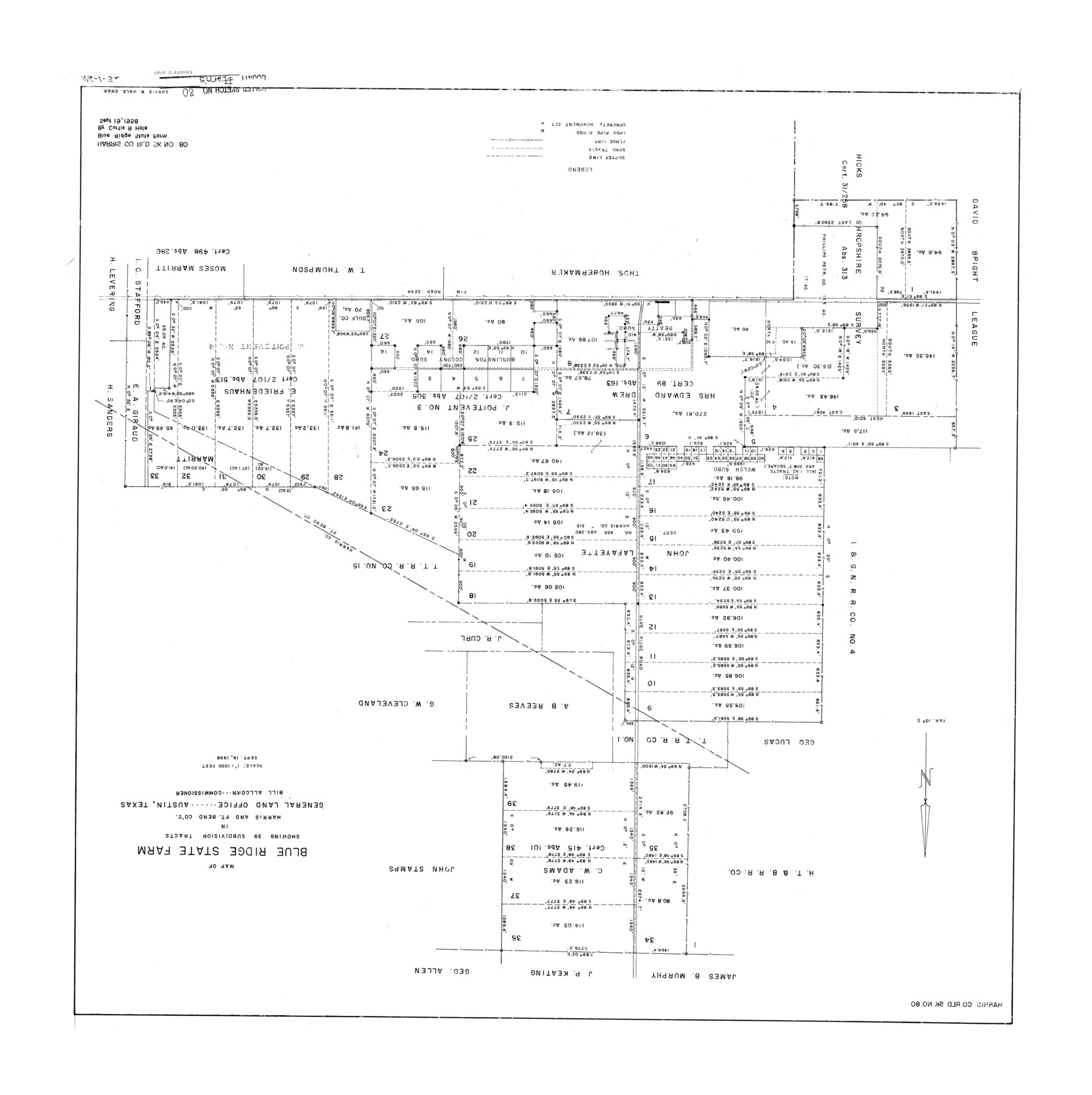
Harris County Rolled Sketch 80
Map of Blue Ridge State Farm showing 39 subdivision tracts in Harris and Ft. Bend Cos.
-
Map/Doc
6116
-
Collection
General Map Collection
-
Object Dates
1958/9/19 (Creation Date)
1958/11/17 (File Date)
-
People and Organizations
Curtis R. Hale (Surveyor/Engineer)
-
Counties
Harris Fort Bend
-
Subjects
Prison Farms Surveying Rolled Sketch
-
Height x Width
31.1 x 31.0 inches
79.0 x 78.7 cm
-
Scale
1" = 1000 feet
-
Comments
See Fort Bend County Rolled Sketch 10 (44707) for field notes.
Related maps
Fort Bend County Rolled Sketch 10

Print $99.00
- Digital $50.00
Fort Bend County Rolled Sketch 10
1958
Size 9.9 x 15.9 inches
Map/Doc 44707
Part of: General Map Collection
Map of Nacogdoches County

Print $40.00
- Digital $50.00
Map of Nacogdoches County
1839
Size 81.0 x 38.5 inches
Map/Doc 93375
Schleicher County Working Sketch 3

Print $20.00
- Digital $50.00
Schleicher County Working Sketch 3
1914
Size 23.2 x 17.6 inches
Map/Doc 63805
Tom Green County Rolled Sketch 5

Print $20.00
- Digital $50.00
Tom Green County Rolled Sketch 5
1947
Size 44.9 x 35.0 inches
Map/Doc 9997
Flight Mission No. DCL-6C, Frame 23, Kenedy County

Print $20.00
- Digital $50.00
Flight Mission No. DCL-6C, Frame 23, Kenedy County
1943
Size 18.7 x 22.3 inches
Map/Doc 85880
Flight Mission No. DAG-26K, Frame 80, Matagorda County

Print $20.00
- Digital $50.00
Flight Mission No. DAG-26K, Frame 80, Matagorda County
1953
Size 18.5 x 22.3 inches
Map/Doc 86585
Newton County Sketch File 4b

Print $22.00
- Digital $50.00
Newton County Sketch File 4b
Size 7.6 x 12.2 inches
Map/Doc 32364
Val Verde Co.

Print $20.00
- Digital $50.00
Val Verde Co.
1908
Size 39.8 x 38.7 inches
Map/Doc 63100
Brewster County Rolled Sketch 114

Print $20.00
- Digital $50.00
Brewster County Rolled Sketch 114
1964
Size 11.6 x 17.3 inches
Map/Doc 5273
Presidio County Sketch File A

Print $20.00
- Digital $50.00
Presidio County Sketch File A
Size 25.6 x 21.4 inches
Map/Doc 11700
Edwards County

Print $20.00
- Digital $50.00
Edwards County
1893
Size 30.8 x 33.1 inches
Map/Doc 3507
Comal County Sketch File 10

Print $4.00
- Digital $50.00
Comal County Sketch File 10
1849
Size 12.7 x 7.6 inches
Map/Doc 19020

You may also like
Sketch in Terry and Yoakum Counties

Print $20.00
- Digital $50.00
Sketch in Terry and Yoakum Counties
1945
Size 20.7 x 38.5 inches
Map/Doc 91939
Eastland County Boundary File 26a

Print $32.00
- Digital $50.00
Eastland County Boundary File 26a
Size 12.7 x 8.1 inches
Map/Doc 52813
[Connecting lines from west corner of S. K. & K. Block M6 to northwest corner section 1, J. G. & S. M. Blk. 2Z]
![90399, [Connecting lines from west corner of S. K. & K. Block M6 to northwest corner section 1, J. G. & S. M. Blk. 2Z], Twichell Survey Records](https://historictexasmaps.com/wmedia_w700/maps/90399-1.tif.jpg)
Print $20.00
- Digital $50.00
[Connecting lines from west corner of S. K. & K. Block M6 to northwest corner section 1, J. G. & S. M. Blk. 2Z]
Size 25.1 x 17.0 inches
Map/Doc 90399
Atascosa County Rolled Sketch 20

Print $20.00
- Digital $50.00
Atascosa County Rolled Sketch 20
1956
Size 36.0 x 44.0 inches
Map/Doc 8432
Dawson County Rolled Sketch 11

Print $20.00
- Digital $50.00
Dawson County Rolled Sketch 11
1961
Size 21.5 x 26.1 inches
Map/Doc 5694
Pecos County Rolled Sketch 32A

Print $7.00
- Digital $50.00
Pecos County Rolled Sketch 32A
1890
Size 10.5 x 15.2 inches
Map/Doc 48096
Jefferson County Working Sketch 24

Print $20.00
- Digital $50.00
Jefferson County Working Sketch 24
1977
Size 28.4 x 44.5 inches
Map/Doc 66567
Flight Mission No. DQO-7K, Frame 106, Galveston County

Print $20.00
- Digital $50.00
Flight Mission No. DQO-7K, Frame 106, Galveston County
1952
Size 18.5 x 22.6 inches
Map/Doc 85121
West Part of Liberty Co.

Print $20.00
- Digital $50.00
West Part of Liberty Co.
1977
Size 46.2 x 35.5 inches
Map/Doc 73220
Flight Mission No. CRK-5P, Frame 162, Refugio County

Print $20.00
- Digital $50.00
Flight Mission No. CRK-5P, Frame 162, Refugio County
1956
Size 18.5 x 22.3 inches
Map/Doc 86943
Milam County Sketch File 5

Print $4.00
- Digital $50.00
Milam County Sketch File 5
1901
Size 14.2 x 8.7 inches
Map/Doc 31632
Nueces County Rolled Sketch 128 A-E

Print $10.00
- Digital $50.00
Nueces County Rolled Sketch 128 A-E
1998
Size 11.0 x 8.5 inches
Map/Doc 41611