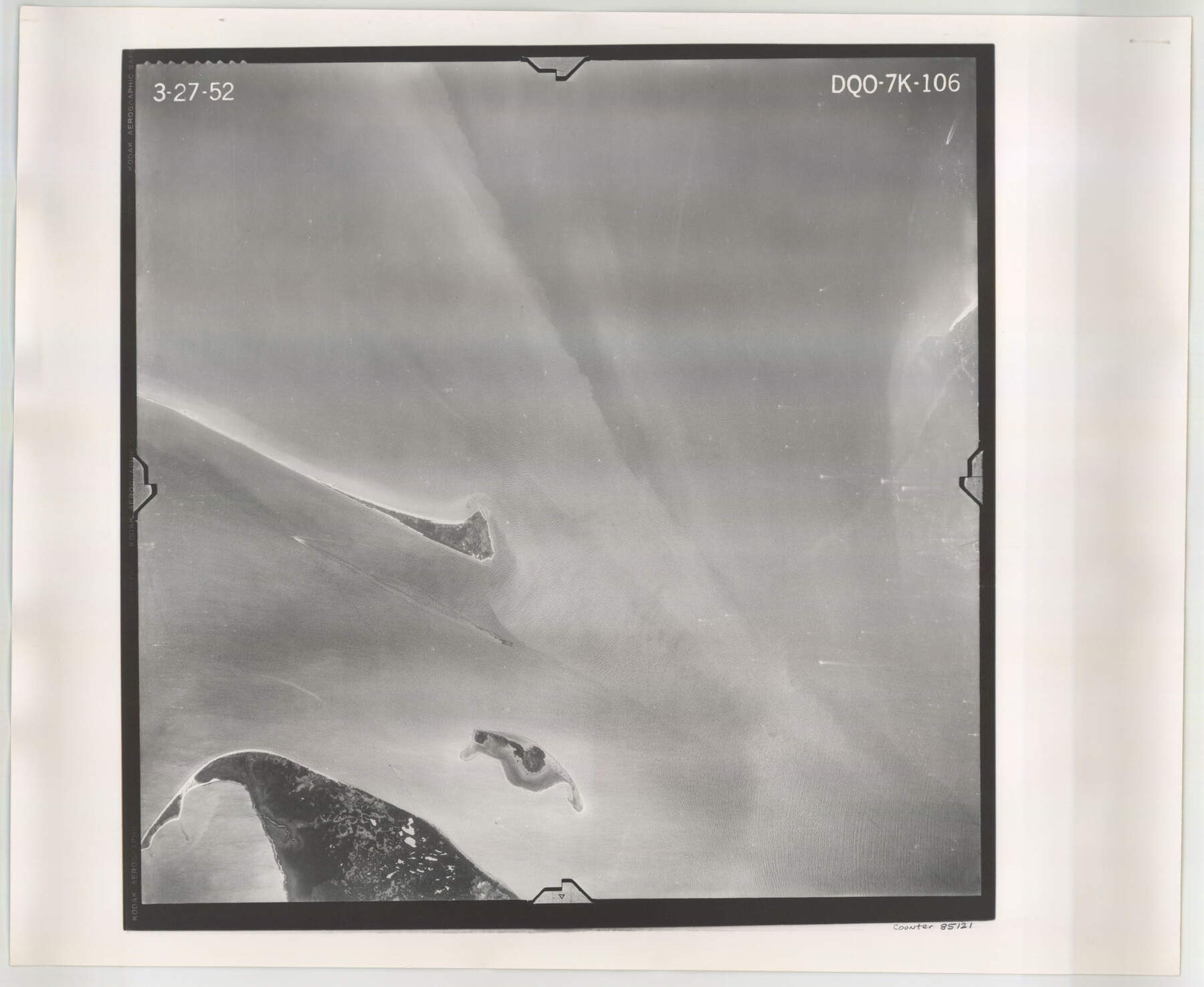
Flight Mission No. DQO-7K, Frame 106, Galveston County
DQO-7K-106
-
Map/Doc
85121
-
Collection
General Map Collection
-
Object Dates
1952/3/27 (Creation Date)
-
People and Organizations
U. S. Department of Agriculture (Publisher)
-
Counties
Galveston
-
Subjects
Aerial Photograph
-
Height x Width
18.5 x 22.6 inches
47.0 x 57.4 cm
-
Comments
Flown by Aero Exploration Company of Tulsa, Oklahoma.
Part of: General Map Collection
Flight Mission No. BRA-3M, Frame 128, Jefferson County

Print $20.00
- Digital $50.00
Flight Mission No. BRA-3M, Frame 128, Jefferson County
1953
Size 18.5 x 22.3 inches
Map/Doc 85402

Flight Mission No. DQN-1K, Frame 71, Calhoun County

Print $20.00
- Digital $50.00
Flight Mission No. DQN-1K, Frame 71, Calhoun County
1953
Size 18.9 x 22.5 inches
Map/Doc 84158
Flight Mission No. BRE-1P, Frame 50, Nueces County

Print $20.00
- Digital $50.00
Flight Mission No. BRE-1P, Frame 50, Nueces County
1956
Size 18.5 x 22.3 inches
Map/Doc 86639
Culberson County Working Sketch 39

Print $40.00
- Digital $50.00
Culberson County Working Sketch 39
1966
Size 37.9 x 82.7 inches
Map/Doc 68492
Pecos County Rolled Sketch 142

Print $20.00
- Digital $50.00
Pecos County Rolled Sketch 142
Size 26.9 x 41.9 inches
Map/Doc 7276
Madison County Working Sketch 3

Print $20.00
- Digital $50.00
Madison County Working Sketch 3
1945
Size 29.3 x 21.6 inches
Map/Doc 70765
Kerr County Sketch File 10

Print $6.00
- Digital $50.00
Kerr County Sketch File 10
Size 13.9 x 10.6 inches
Map/Doc 28877
Terrell County Sketch File 22W

Print $20.00
- Digital $50.00
Terrell County Sketch File 22W
Size 19.6 x 21.7 inches
Map/Doc 12423
Brooks County Working Sketch 3

Print $20.00
- Digital $50.00
Brooks County Working Sketch 3
Size 16.2 x 21.3 inches
Map/Doc 67787
Flight Mission No. BRA-17M, Frame 7, Jefferson County

Print $20.00
- Digital $50.00
Flight Mission No. BRA-17M, Frame 7, Jefferson County
1953
Size 18.7 x 22.3 inches
Map/Doc 85788

You may also like
Reeves County Rolled Sketch 14

Print $20.00
- Digital $50.00
Reeves County Rolled Sketch 14
Size 17.7 x 21.8 inches
Map/Doc 7482
[I. & G. N. RR. Co. Blk. 1]
![89805, [I. & G. N. RR. Co. Blk. 1], Twichell Survey Records](https://historictexasmaps.com/wmedia_w700/maps/89805-1.tif.jpg)
Print $40.00
- Digital $50.00
[I. & G. N. RR. Co. Blk. 1]
Size 36.7 x 49.0 inches
Map/Doc 89805
Jackson County Sketch File 3

Print $34.00
- Digital $50.00
Jackson County Sketch File 3
1875
Size 7.9 x 7.7 inches
Map/Doc 27621
Somervell County Working Sketch 1

Print $20.00
- Digital $50.00
Somervell County Working Sketch 1
1950
Size 17.8 x 15.4 inches
Map/Doc 63905
Travis County Appraisal District Plat Map 2_1004

Print $20.00
- Digital $50.00
Travis County Appraisal District Plat Map 2_1004
Size 21.4 x 26.5 inches
Map/Doc 94238
San Patricio County Sketch File 29

Print $10.00
San Patricio County Sketch File 29
1936
Size 11.3 x 8.8 inches
Map/Doc 36111
Kleberg County Rolled Sketch 10-14

Print $20.00
- Digital $50.00
Kleberg County Rolled Sketch 10-14
1951
Size 38.0 x 33.2 inches
Map/Doc 9404
Dallas County Working Sketch 21

Print $20.00
- Digital $50.00
Dallas County Working Sketch 21
2008
Size 32.6 x 33.9 inches
Map/Doc 88761
Jefferson County Sketch File 53

Print $36.00
- Digital $50.00
Jefferson County Sketch File 53
1973
Size 11.2 x 8.9 inches
Map/Doc 28255
Angelina County Sketch File 31

Print $8.00
- Digital $50.00
Angelina County Sketch File 31
1988
Size 11.2 x 8.8 inches
Map/Doc 13089
Garza County Rolled Sketch 17

Print $20.00
- Digital $50.00
Garza County Rolled Sketch 17
1959
Size 32.3 x 37.6 inches
Map/Doc 6003
[Charles Welch, J. D. Brown, and surrounding surveys]
![91010, [Charles Welch, J. D. Brown, and surrounding surveys], Twichell Survey Records](https://historictexasmaps.com/wmedia_w700/maps/91010-1.tif.jpg)
Print $20.00
- Digital $50.00
[Charles Welch, J. D. Brown, and surrounding surveys]
Size 37.4 x 24.0 inches
Map/Doc 91010