Angelina County Sketch File 31
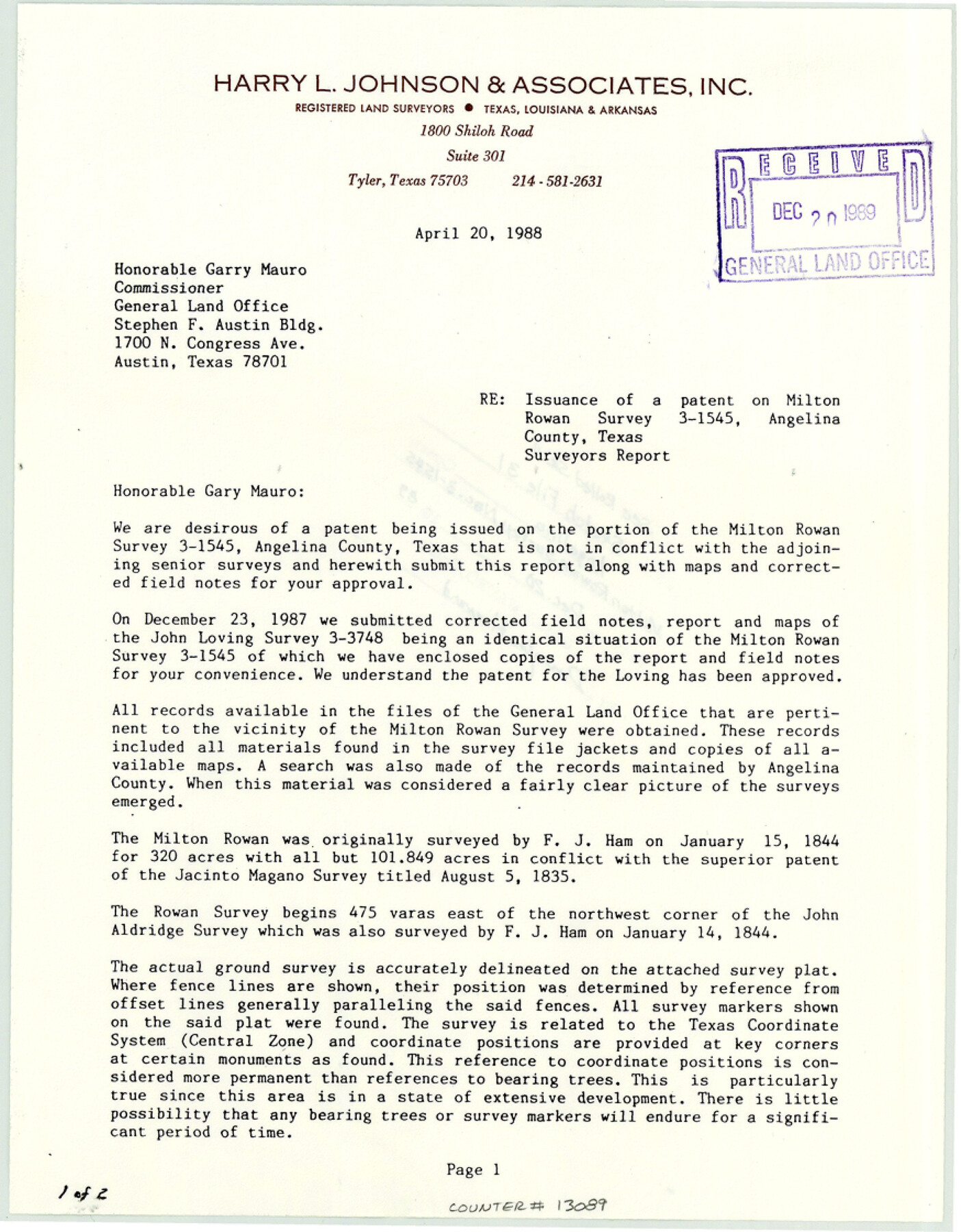
[Surveyor's report regarding Milton Rowan survey, NAC 3-1545]
-
Map/Doc
13089
-
Collection
General Map Collection
-
Object Dates
1988/4/20 (Creation Date)
1989/12/20 (File Date)
-
People and Organizations
Bill H. Burton (Surveyor/Engineer)
-
Counties
Angelina
-
Subjects
Surveying Sketch File
-
Height x Width
11.2 x 8.8 inches
28.4 x 22.4 cm
-
Medium
paper, print
-
Comments
See Angelina County Rolled Sketch 4 (77187) for sketch.
Related maps
Angelina County Rolled Sketch 4

Print $20.00
- Digital $50.00
Angelina County Rolled Sketch 4
Size 24.9 x 36.9 inches
Map/Doc 77187
Part of: General Map Collection
Matagorda Bay Including Lavaca and Tres Palacios Bays

Print $40.00
- Digital $50.00
Matagorda Bay Including Lavaca and Tres Palacios Bays
1973
Size 37.0 x 48.4 inches
Map/Doc 73363
Maps of Gulf Intracoastal Waterway, Texas - Sabine River to the Rio Grande and connecting waterways including ship channels

Print $20.00
- Digital $50.00
Maps of Gulf Intracoastal Waterway, Texas - Sabine River to the Rio Grande and connecting waterways including ship channels
1966
Size 14.4 x 22.2 inches
Map/Doc 61943
Karnes County Sketch File 16

Print $20.00
- Digital $50.00
Karnes County Sketch File 16
1950
Size 14.4 x 30.7 inches
Map/Doc 11905
Galveston County Sketch File 43

Print $40.00
- Digital $50.00
Galveston County Sketch File 43
1915
Size 19.4 x 15.1 inches
Map/Doc 11539
Trinity County Sketch File 5b

Print $4.00
- Digital $50.00
Trinity County Sketch File 5b
1855
Size 12.6 x 8.0 inches
Map/Doc 38506
Sterling County Sketch File 15

Print $8.00
- Digital $50.00
Sterling County Sketch File 15
1935
Size 11.1 x 8.8 inches
Map/Doc 37150
Mills County Sketch File 18

Print $4.00
- Digital $50.00
Mills County Sketch File 18
1872
Size 12.1 x 8.1 inches
Map/Doc 31668
Nacogdoches County Working Sketch 11

Print $20.00
- Digital $50.00
Nacogdoches County Working Sketch 11
1985
Size 41.1 x 28.0 inches
Map/Doc 71227
Comal County Rolled Sketch 2

Print $20.00
- Digital $50.00
Comal County Rolled Sketch 2
Size 21.6 x 13.0 inches
Map/Doc 5536
Fractional Township No. 9 South Range No. 23 East of the Indian Meridian, Indian Territory

Print $20.00
- Digital $50.00
Fractional Township No. 9 South Range No. 23 East of the Indian Meridian, Indian Territory
1898
Size 19.2 x 24.4 inches
Map/Doc 75240
Presidio County Rolled Sketch 140

Print $20.00
- Digital $50.00
Presidio County Rolled Sketch 140
2003
Size 44.4 x 34.7 inches
Map/Doc 78654
United States - Gulf Coast - Galveston to Rio Grande

Print $20.00
- Digital $50.00
United States - Gulf Coast - Galveston to Rio Grande
Size 27.9 x 18.3 inches
Map/Doc 72739
You may also like
From Citizens of Washington County Living East of the Brazos River and in the Forks of the Navasota and Brazos Rivers and South of the Old San Antonio Road for the Creation of a New County (Unnamed), January 13, 1840

Print $20.00
From Citizens of Washington County Living East of the Brazos River and in the Forks of the Navasota and Brazos Rivers and South of the Old San Antonio Road for the Creation of a New County (Unnamed), January 13, 1840
2020
Size 20.4 x 21.7 inches
Map/Doc 96388
Wilbarger County Working Sketch 12

Print $20.00
- Digital $50.00
Wilbarger County Working Sketch 12
1953
Size 42.2 x 33.5 inches
Map/Doc 72550
Foard County Boundary File 5a

Print $40.00
- Digital $50.00
Foard County Boundary File 5a
Size 18.2 x 44.4 inches
Map/Doc 53546
Kimble County Sketch File 36

Print $20.00
- Digital $50.00
Kimble County Sketch File 36
1963
Size 22.2 x 25.0 inches
Map/Doc 11932
Hale County Working Sketch 1

Print $20.00
- Digital $50.00
Hale County Working Sketch 1
1910
Size 34.5 x 22.1 inches
Map/Doc 63321
[Sketch of Surveys on Big Sandy Creek]
![179, [Sketch of Surveys on Big Sandy Creek], General Map Collection](https://historictexasmaps.com/wmedia_w700/maps/179.tif.jpg)
Print $2.00
- Digital $50.00
[Sketch of Surveys on Big Sandy Creek]
1841
Size 8.2 x 9.2 inches
Map/Doc 179
University of Texas System University Lands

Print $20.00
- Digital $50.00
University of Texas System University Lands
Size 17.8 x 23.4 inches
Map/Doc 93245
Map of Texas and Parts of Adjoining Territories

Print $20.00
Map of Texas and Parts of Adjoining Territories
1899
Size 33.7 x 36.0 inches
Map/Doc 79304
Llano County Working Sketch 15

Print $20.00
- Digital $50.00
Llano County Working Sketch 15
2007
Size 46.0 x 26.2 inches
Map/Doc 87372
Castro County Sketch File 4k

Print $4.00
- Digital $50.00
Castro County Sketch File 4k
Size 13.6 x 8.6 inches
Map/Doc 17485
Flight Mission No. DAG-22K, Frame 87, Matagorda County

Print $20.00
- Digital $50.00
Flight Mission No. DAG-22K, Frame 87, Matagorda County
1953
Size 18.6 x 22.4 inches
Map/Doc 86471
Flight Mission No. DQO-3K, Frame 29, Galveston County

Print $20.00
- Digital $50.00
Flight Mission No. DQO-3K, Frame 29, Galveston County
1952
Size 18.8 x 22.4 inches
Map/Doc 85070