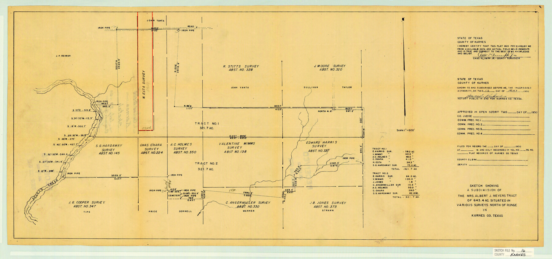
Karnes County Sketch File 16
Sketch showing a subdivision of the Mrs. Albert J. Meyers tract of 643.4 ac. Situated in various surveys north of Runge in Karnes Co. Texas
-
Map/Doc
11905
-
Collection
General Map Collection
-
Object Dates
5/16/1950 (Creation Date)
7/29/1950 (File Date)
-
People and Organizations
Charles Klumpp, Jr. (Surveyor/Engineer)
-
Counties
Karnes
-
Subjects
Surveying Sketch File
-
Height x Width
14.4 x 30.7 inches
36.6 x 78.0 cm
-
Medium
blueprint/diazo
-
Scale
1" = 600 feet
-
Features
Ecleto Creek
Part of: General Map Collection
[F. W. & D. C. Ry. Co. Alignment and Right of Way Map, Clay County]
![64743, [F. W. & D. C. Ry. Co. Alignment and Right of Way Map, Clay County], General Map Collection](https://historictexasmaps.com/wmedia_w700/maps/64743-GC.tif.jpg)
Print $20.00
- Digital $50.00
[F. W. & D. C. Ry. Co. Alignment and Right of Way Map, Clay County]
1927
Size 18.6 x 11.8 inches
Map/Doc 64743
St. Louis, Brownsville & Mexico Railway Location Map from Mile 20 to Mile 40

Print $40.00
- Digital $50.00
St. Louis, Brownsville & Mexico Railway Location Map from Mile 20 to Mile 40
1905
Size 19.2 x 61.4 inches
Map/Doc 64078
Angelina County Working Sketch 25

Print $20.00
- Digital $50.00
Angelina County Working Sketch 25
1954
Size 25.0 x 17.5 inches
Map/Doc 67107
Nueces County Sketch File 81

Print $20.00
- Digital $50.00
Nueces County Sketch File 81
Size 11.2 x 8.7 inches
Map/Doc 33155
Bell County Sketch File 13

Print $4.00
- Digital $50.00
Bell County Sketch File 13
1854
Size 9.3 x 8.1 inches
Map/Doc 14390
Flight Mission No. DQN-2K, Frame 97, Calhoun County

Print $20.00
- Digital $50.00
Flight Mission No. DQN-2K, Frame 97, Calhoun County
1953
Size 18.7 x 22.4 inches
Map/Doc 84287
Midland County Boundary File 4a

Print $40.00
- Digital $50.00
Midland County Boundary File 4a
Size 36.2 x 54.5 inches
Map/Doc 57185
Brewster County Sketch File D

Print $4.00
- Digital $50.00
Brewster County Sketch File D
1938
Size 14.5 x 8.8 inches
Map/Doc 15738

Nueces River, Corpus Christi Sheet No. 1-A

Print $6.00
- Digital $50.00
Nueces River, Corpus Christi Sheet No. 1-A
1938
Size 21.9 x 33.2 inches
Map/Doc 65090
Map of the Fort Worth and Denver City Railway

Print $40.00
- Digital $50.00
Map of the Fort Worth and Denver City Railway
1873
Size 31.6 x 90.3 inches
Map/Doc 64778
Hill County Sketch File 1

Print $4.00
- Digital $50.00
Hill County Sketch File 1
1857
Size 9.0 x 7.9 inches
Map/Doc 26459
You may also like
Galveston County Sketch File 51

Print $20.00
- Digital $50.00
Galveston County Sketch File 51
1895
Size 25.7 x 40.2 inches
Map/Doc 10457

Right of Way and Track Map, International & Gt. Northern Ry. operated by the International & Gt. Northern Ry. Co. Gulf Division, Mineola Branch

Print $40.00
- Digital $50.00
Right of Way and Track Map, International & Gt. Northern Ry. operated by the International & Gt. Northern Ry. Co. Gulf Division, Mineola Branch
1917
Size 25.2 x 120.8 inches
Map/Doc 64703
Flight Mission No. DCL-6C, Frame 27, Kenedy County

Print $20.00
- Digital $50.00
Flight Mission No. DCL-6C, Frame 27, Kenedy County
1943
Size 18.7 x 22.4 inches
Map/Doc 85884
General Highway Map, Washington County, Texas

Print $20.00
General Highway Map, Washington County, Texas
1961
Size 18.1 x 24.7 inches
Map/Doc 79703
Map of Reeves County

Print $20.00
- Digital $50.00
Map of Reeves County
1892
Size 44.8 x 34.0 inches
Map/Doc 3983
Duval County Sketch File 21

Print $42.00
- Digital $50.00
Duval County Sketch File 21
1879
Size 17.0 x 28.8 inches
Map/Doc 11385
Houston County Sketch File 23

Print $6.00
- Digital $50.00
Houston County Sketch File 23
1852
Size 6.5 x 5.2 inches
Map/Doc 26793
Duval County Working Sketch 4

Print $20.00
- Digital $50.00
Duval County Working Sketch 4
1928
Size 25.8 x 24.9 inches
Map/Doc 76445
Burnet County Working Sketch 1

Print $20.00
- Digital $50.00
Burnet County Working Sketch 1
1916
Size 22.4 x 31.9 inches
Map/Doc 67844
Lynn County Sketch File 13

Print $18.00
- Digital $50.00
Lynn County Sketch File 13
1903
Size 10.6 x 8.1 inches
Map/Doc 30482
Hispania Nova

Print $20.00
- Digital $50.00
Hispania Nova
1597
Size 12.0 x 14.9 inches
Map/Doc 94120