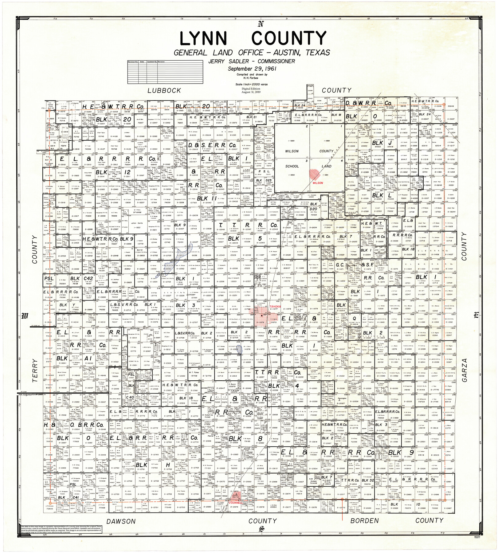
Lynn County
General Land Office Official County Map
-
Map/Doc
95577
-
Collection
General Map Collection
-
Object Dates
2019/8/31 (Revision Date)
1961/9/29 (Creation Date)
-
People and Organizations
Cheyenne Betancourt (Draftsman)
H.H. Forbes (Draftsman)
H.H. Forbes (Compiler)
Jerry Sadler (GLO Commissioner)
-
Counties
Lynn
-
Subjects
County OCM
-
Height x Width
41.3 x 37.5 inches
104.9 x 95.3 cm
-
Medium
digital image
-
Scale
1" = 2000 varas
Part of: General Map Collection
Grimes County Working Sketch 7

Print $20.00
- Digital $50.00
Grimes County Working Sketch 7
1963
Size 27.2 x 33.0 inches
Map/Doc 63298
Plat of a survey on Padre Island in Willacy and Kenedy Counties surveyed for South Padre Development Corporation by Claunch and Associates

Print $20.00
- Digital $50.00
Plat of a survey on Padre Island in Willacy and Kenedy Counties surveyed for South Padre Development Corporation by Claunch and Associates
1973
Size 46.5 x 41.6 inches
Map/Doc 61424
Edwards County

Print $20.00
- Digital $50.00
Edwards County
1883
Size 28.2 x 17.9 inches
Map/Doc 3505
Houston Ship Channel, Atkinson Island to Alexander Island

Print $40.00
- Digital $50.00
Houston Ship Channel, Atkinson Island to Alexander Island
1973
Size 36.7 x 50.2 inches
Map/Doc 69902
Kerr County Working Sketch 8

Print $20.00
- Digital $50.00
Kerr County Working Sketch 8
1948
Size 18.1 x 23.6 inches
Map/Doc 70039
Reeves County Working Sketch 62

Print $20.00
- Digital $50.00
Reeves County Working Sketch 62
1984
Size 29.5 x 35.4 inches
Map/Doc 63505
[Photostats of section of Hydrographic Surveys H-5399, H-4822 and H-470, Mouth of Trinity River]
![61154, [Photostats of section of Hydrographic Surveys H-5399, H-4822 and H-470, Mouth of Trinity River], General Map Collection](https://historictexasmaps.com/wmedia_w700/maps/61154.tif.jpg)
Print $20.00
- Digital $50.00
[Photostats of section of Hydrographic Surveys H-5399, H-4822 and H-470, Mouth of Trinity River]
1933
Size 18.2 x 25.8 inches
Map/Doc 61154
Flight Mission No. CGI-3N, Frame 51, Cameron County

Print $20.00
- Digital $50.00
Flight Mission No. CGI-3N, Frame 51, Cameron County
1954
Size 18.6 x 22.2 inches
Map/Doc 84557
Wise County Working Sketch 23

Print $20.00
- Digital $50.00
Wise County Working Sketch 23
1981
Size 43.6 x 36.9 inches
Map/Doc 72637
Orange County Working Sketch 48

Print $20.00
- Digital $50.00
Orange County Working Sketch 48
1991
Size 13.3 x 19.9 inches
Map/Doc 71380
Flight Mission No. BRA-8M, Frame 67, Jefferson County

Print $20.00
- Digital $50.00
Flight Mission No. BRA-8M, Frame 67, Jefferson County
1953
Size 18.8 x 22.5 inches
Map/Doc 85587
Jefferson County Working Sketch 42

Print $20.00
- Digital $50.00
Jefferson County Working Sketch 42
1996
Size 31.7 x 47.2 inches
Map/Doc 66586
You may also like
Dimmit County Working Sketch 50

Print $20.00
- Digital $50.00
Dimmit County Working Sketch 50
1981
Size 34.0 x 39.0 inches
Map/Doc 68711
Shelby County Rolled Sketch 7

Print $40.00
- Digital $50.00
Shelby County Rolled Sketch 7
1945
Size 61.1 x 44.4 inches
Map/Doc 9922
Leon County Sketch File 27

Print $20.00
- Digital $50.00
Leon County Sketch File 27
1948
Size 11.2 x 8.8 inches
Map/Doc 29811
Presidio County Rolled Sketch 139

Print $20.00
- Digital $50.00
Presidio County Rolled Sketch 139
2002
Size 24.5 x 27.5 inches
Map/Doc 78647
Milam County Rolled Sketch 3A

Print $40.00
- Digital $50.00
Milam County Rolled Sketch 3A
1967
Size 49.5 x 43.3 inches
Map/Doc 9522
The Judicial District/County of Spring Creek. Abolished, Spring 1842

Print $20.00
The Judicial District/County of Spring Creek. Abolished, Spring 1842
2020
Size 15.7 x 21.7 inches
Map/Doc 96349
Lipscomb County Boundary File 14

Print $62.00
- Digital $50.00
Lipscomb County Boundary File 14
Size 13.3 x 8.8 inches
Map/Doc 56355
Garza County Rolled Sketch 13

Print $26.00
- Digital $50.00
Garza County Rolled Sketch 13
1935
Size 45.5 x 36.7 inches
Map/Doc 9047
[Surveys in Burleson County]
![78355, [Surveys in Burleson County], General Map Collection](https://historictexasmaps.com/wmedia_w700/maps/78355.tif.jpg)
Print $20.00
- Digital $50.00
[Surveys in Burleson County]
Size 19.6 x 28.3 inches
Map/Doc 78355
Map of Hale County

Print $20.00
- Digital $50.00
Map of Hale County
1900
Size 47.8 x 38.6 inches
Map/Doc 66847
Flight Mission No. DQN-2K, Frame 115, Calhoun County

Print $20.00
- Digital $50.00
Flight Mission No. DQN-2K, Frame 115, Calhoun County
1953
Size 18.6 x 22.3 inches
Map/Doc 84291
Orange County Working Sketch 15

Print $20.00
- Digital $50.00
Orange County Working Sketch 15
1928
Size 19.3 x 24.6 inches
Map/Doc 71347