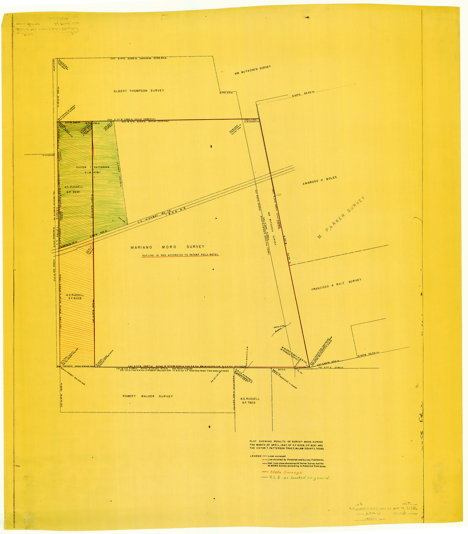
Milam County Rolled Sketch 3A
Plat showing results of survey made during the month of April, 1967, of SF-8008, SF-8281 and the Victor T. Patterson tract, Milam County, Texas
-
Map/Doc
9522
-
Collection
General Map Collection
-
Object Dates
1967 (Creation Date)
1974/11/19 (File Date)
-
People and Organizations
Ed McCarty (Surveyor/Engineer)
-
Counties
Milam
-
Subjects
Surveying Rolled Sketch
-
Height x Width
49.5 x 43.3 inches
125.7 x 110.0 cm
-
Medium
blueprint/diazo
Part of: General Map Collection
Brazos Santiago, Texas

Print $20.00
- Digital $50.00
Brazos Santiago, Texas
1867
Size 25.1 x 18.3 inches
Map/Doc 72988
Flight Mission No. CRK-3P, Frame 63, Refugio County

Print $20.00
- Digital $50.00
Flight Mission No. CRK-3P, Frame 63, Refugio County
1956
Size 18.5 x 22.4 inches
Map/Doc 86905
Brewster County Working Sketch 93

Print $40.00
- Digital $50.00
Brewster County Working Sketch 93
1975
Size 60.6 x 39.9 inches
Map/Doc 67693
Brazos Santiago, Texas

Print $20.00
- Digital $50.00
Brazos Santiago, Texas
1900
Size 18.2 x 27.1 inches
Map/Doc 73034
Flight Mission No. CRC-3R, Frame 97, Chambers County

Print $20.00
- Digital $50.00
Flight Mission No. CRC-3R, Frame 97, Chambers County
1956
Size 18.5 x 22.3 inches
Map/Doc 84835
Maps of Gulf Intracoastal Waterway, Texas - Sabine River to the Rio Grande and connecting waterways including ship channels

Print $20.00
- Digital $50.00
Maps of Gulf Intracoastal Waterway, Texas - Sabine River to the Rio Grande and connecting waterways including ship channels
1966
Size 14.6 x 22.2 inches
Map/Doc 61979
Brazoria County Rolled Sketch 18A

Print $20.00
- Digital $50.00
Brazoria County Rolled Sketch 18A
1913
Size 28.3 x 25.1 inches
Map/Doc 5164
Flight Mission No. CRK-3P, Frame 68, Refugio County

Print $20.00
- Digital $50.00
Flight Mission No. CRK-3P, Frame 68, Refugio County
1956
Size 18.7 x 22.5 inches
Map/Doc 86910
Brazoria County Working Sketch 21

Print $20.00
- Digital $50.00
Brazoria County Working Sketch 21
1954
Size 41.5 x 41.8 inches
Map/Doc 67506
DeWitt County Working Sketch 12

Print $20.00
- Digital $50.00
DeWitt County Working Sketch 12
1981
Size 17.0 x 12.5 inches
Map/Doc 68602
Old Miscellaneous File 1

Print $172.00
- Digital $50.00
Old Miscellaneous File 1
Size 8.3 x 6.6 inches
Map/Doc 75320
McMullen County Working Sketch 17

Print $20.00
- Digital $50.00
McMullen County Working Sketch 17
1941
Size 35.1 x 21.8 inches
Map/Doc 70718
You may also like
Houston Ship Channel, Alexander Island to Carpenter Bayou

Print $40.00
- Digital $50.00
Houston Ship Channel, Alexander Island to Carpenter Bayou
1992
Size 35.3 x 49.3 inches
Map/Doc 69917
Runnels County Rolled Sketch 51

Print $20.00
- Digital $50.00
Runnels County Rolled Sketch 51
Size 26.1 x 34.3 inches
Map/Doc 7536
Kimble County Working Sketch 24

Print $20.00
- Digital $50.00
Kimble County Working Sketch 24
1930
Size 23.3 x 17.4 inches
Map/Doc 70092
Hardeman County Working Sketch 5

Print $20.00
- Digital $50.00
Hardeman County Working Sketch 5
Size 23.0 x 35.7 inches
Map/Doc 63386
Matagorda County Sketch File 9

Print $7.00
- Digital $50.00
Matagorda County Sketch File 9
1877
Size 10.1 x 8.1 inches
Map/Doc 30752
[Blocks M-22 and M-25 and vicinity]
![91138, [Blocks M-22 and M-25 and vicinity], Twichell Survey Records](https://historictexasmaps.com/wmedia_w700/maps/91138-1.tif.jpg)
Print $20.00
- Digital $50.00
[Blocks M-22 and M-25 and vicinity]
Size 18.7 x 16.6 inches
Map/Doc 91138
Sketch showing subdivision of surveys in Webb Co., Texas

Print $20.00
- Digital $50.00
Sketch showing subdivision of surveys in Webb Co., Texas
1933
Size 18.2 x 20.1 inches
Map/Doc 459
Tarrant County Working Sketch 18

Print $20.00
- Digital $50.00
Tarrant County Working Sketch 18
1996
Size 20.4 x 18.5 inches
Map/Doc 62435
[Sketch for Mineral Application 16341 - Clear Fork of Brazos River, Taylor & Holcomb]
![65572, [Sketch for Mineral Application 16341 - Clear Fork of Brazos River, Taylor & Holcomb], General Map Collection](https://historictexasmaps.com/wmedia_w700/maps/65572.tif.jpg)
Print $40.00
- Digital $50.00
[Sketch for Mineral Application 16341 - Clear Fork of Brazos River, Taylor & Holcomb]
1926
Size 122.8 x 39.6 inches
Map/Doc 65572
Flight Mission No. DQN-2K, Frame 86, Calhoun County

Print $20.00
- Digital $50.00
Flight Mission No. DQN-2K, Frame 86, Calhoun County
1953
Size 18.6 x 22.2 inches
Map/Doc 84276
Nueces County Rolled Sketch 49

Print $20.00
- Digital $50.00
Nueces County Rolled Sketch 49
1979
Size 21.1 x 20.7 inches
Map/Doc 6888
Brown County Rolled Sketch 2B

Print $20.00
- Digital $50.00
Brown County Rolled Sketch 2B
1984
Size 24.3 x 18.6 inches
Map/Doc 5351