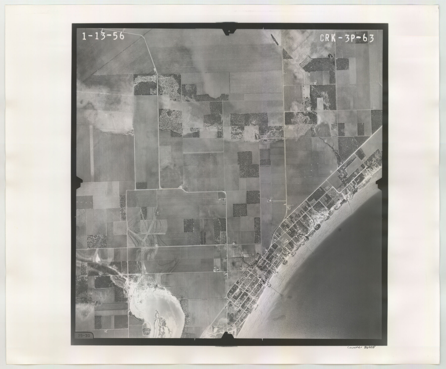
Flight Mission No. CRK-3P, Frame 63, Refugio County
CRK-3P-63
-
Map/Doc
86905
-
Collection
General Map Collection
-
Object Dates
1956/1/13 (Creation Date)
-
People and Organizations
U. S. Department of Agriculture (Publisher)
-
Counties
Refugio
-
Subjects
Aerial Photograph
-
Height x Width
18.5 x 22.4 inches
47.0 x 56.9 cm
-
Comments
Flown by V. L. Beavers and Associates of San Antonio, Texas.
Part of: General Map Collection
Hudspeth County Sketch File 25

Print $10.00
- Digital $50.00
Hudspeth County Sketch File 25
1936
Size 11.3 x 8.7 inches
Map/Doc 26979
McLennan County Sketch File 23

Print $4.00
- Digital $50.00
McLennan County Sketch File 23
Size 5.6 x 3.2 inches
Map/Doc 31297
Edwards County Working Sketch 118

Print $20.00
- Digital $50.00
Edwards County Working Sketch 118
1974
Size 19.5 x 30.4 inches
Map/Doc 68994
Val Verde County Sketch File Z17

Print $24.00
- Digital $50.00
Val Verde County Sketch File Z17
1907
Size 23.7 x 17.5 inches
Map/Doc 12558
Jefferson County Rolled Sketch 34

Print $20.00
- Digital $50.00
Jefferson County Rolled Sketch 34
1957
Size 43.9 x 34.6 inches
Map/Doc 9296
Duval County Working Sketch 25

Print $20.00
- Digital $50.00
Duval County Working Sketch 25
1946
Size 23.7 x 20.1 inches
Map/Doc 68749
Dimmit County Rolled Sketch 6
Print $20.00
- Digital $50.00
Dimmit County Rolled Sketch 6
Size 31.1 x 27.4 inches
Map/Doc 5716
San Patricio County Rolled Sketch 36

Print $40.00
- Digital $50.00
San Patricio County Rolled Sketch 36
Size 42.3 x 48.1 inches
Map/Doc 9899
Val Verde County Working Sketch 6

Print $20.00
- Digital $50.00
Val Verde County Working Sketch 6
1915
Size 23.2 x 20.7 inches
Map/Doc 72141

Frio County Working Sketch 24

Print $20.00
- Digital $50.00
Frio County Working Sketch 24
1992
Size 47.0 x 35.2 inches
Map/Doc 69298
Foard County Sketch File 29

Print $20.00
- Digital $50.00
Foard County Sketch File 29
Size 18.9 x 29.4 inches
Map/Doc 11494
You may also like

Midland County Rolled Sketch T

Print $20.00
- Digital $50.00
Midland County Rolled Sketch T
1933
Size 15.9 x 21.4 inches
Map/Doc 6772
Pressler's Map of the State of Texas

Print $40.00
- Digital $50.00
Pressler's Map of the State of Texas
1858
Size 47.6 x 51.9 inches
Map/Doc 709
Map of Lee County, Texas

Print $20.00
- Digital $50.00
Map of Lee County, Texas
1879
Size 25.7 x 19.8 inches
Map/Doc 562
Brewster County Sketch File N-3

Print $6.00
- Digital $50.00
Brewster County Sketch File N-3
1882
Size 8.6 x 7.6 inches
Map/Doc 15589
Old Miscellaneous File 22

Print $18.00
- Digital $50.00
Old Miscellaneous File 22
1915
Size 14.2 x 8.7 inches
Map/Doc 75591
Map of Caldwell Co.

Print $40.00
- Digital $50.00
Map of Caldwell Co.
1917
Size 48.4 x 43.0 inches
Map/Doc 89748
Llano County Sketch File 15

Print $2.00
- Digital $50.00
Llano County Sketch File 15
Size 10.4 x 7.7 inches
Map/Doc 30391
Sketch showing the route of the military road from Red River to Austin

Print $20.00
- Digital $50.00
Sketch showing the route of the military road from Red River to Austin
1840
Size 33.2 x 13.1 inches
Map/Doc 1752

Duval County Working Sketch 48

Print $20.00
- Digital $50.00
Duval County Working Sketch 48
1981
Size 21.2 x 13.4 inches
Map/Doc 68772
Maverick County Sketch File 19

Print $4.00
- Digital $50.00
Maverick County Sketch File 19
1887
Size 12.8 x 9.0 inches
Map/Doc 31128