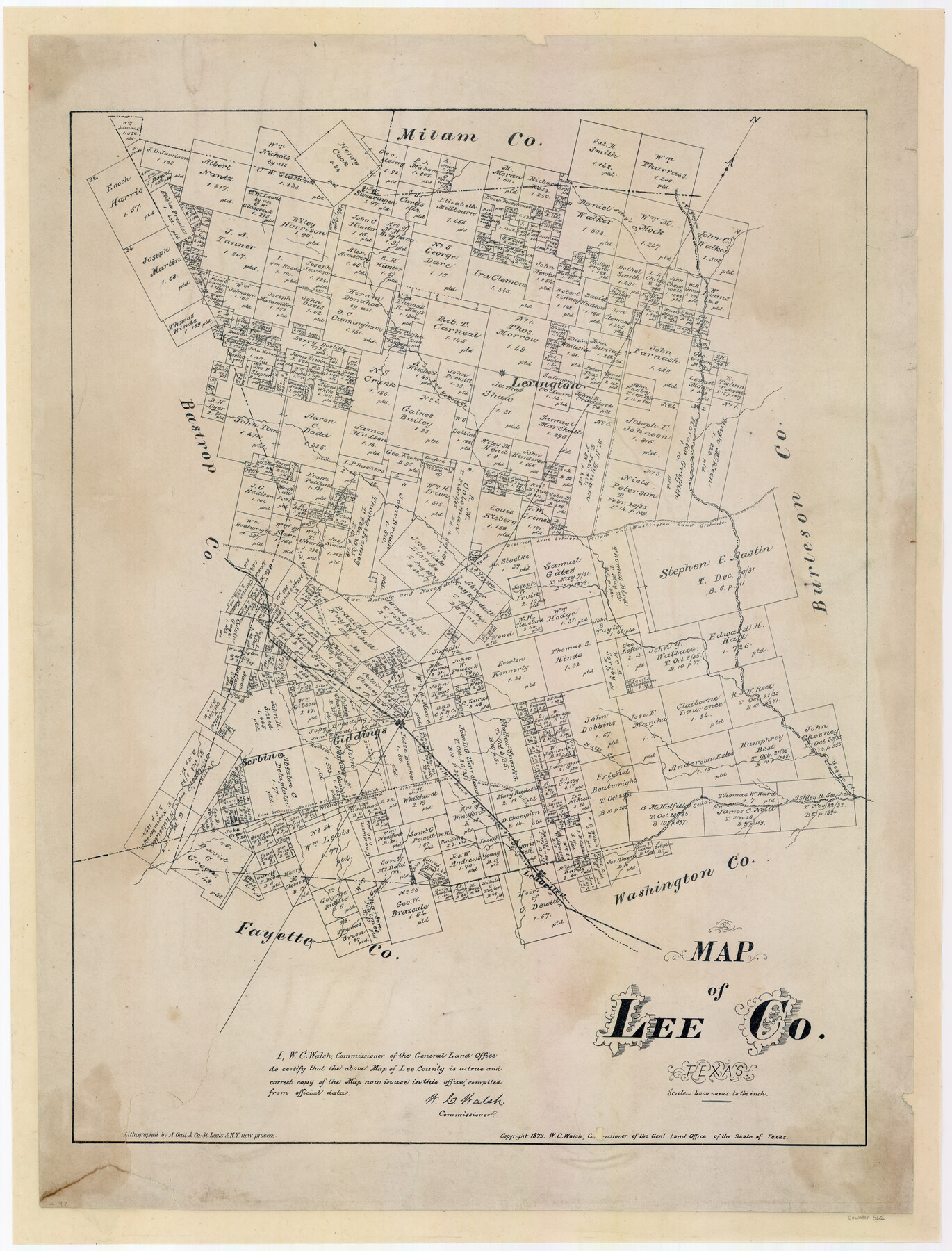
Map of Lee County, Texas
-
Map/Doc
562
-
Collection
Maddox Collection
-
Object Dates
1879 (Creation Date)
1879 (Copyright Date)
-
People and Organizations
General Land Office (Publisher)
W.C. Walsh (GLO Commissioner)
August Gast & Co. (Lithographer)
-
Counties
Lee
-
Subjects
County
-
Height x Width
25.7 x 19.8 inches
65.3 x 50.3 cm
-
Medium
paper, etching/engraving/lithograph
-
Scale
1:4000
-
Comments
Conservation funded in 2009 by Friends of the Texas General Land Office.
-
Features
Alley's Creek
Yegua Creek
Hill's Creek
2nd Yegua Creek
Lexington
Bluff Creek
Giddings
Serbin
Pin Oak Creek
Rabbs Creek
H&TC
Nails Creek
Ledbetter
Green Creek
Part of: Maddox Collection
Sketch H, Dickens County, Texas

Print $20.00
- Digital $50.00
Sketch H, Dickens County, Texas
1902
Size 16.0 x 14.3 inches
Map/Doc 4365
[Surveying Sketch of John Poitevent Block 1, Railroad Lands, et al in Knox County, Texas]
![414, [Surveying Sketch of John Poitevent Block 1, Railroad Lands, et al in Knox County, Texas], Maddox Collection](https://historictexasmaps.com/wmedia_w700/maps/0414.tif.jpg)
Print $3.00
- Digital $50.00
[Surveying Sketch of John Poitevent Block 1, Railroad Lands, et al in Knox County, Texas]
Size 11.9 x 14.2 inches
Map/Doc 414
[Marion County, Texas]
![75777, [Marion County, Texas], Maddox Collection](https://historictexasmaps.com/wmedia_w700/maps/75777.tif.jpg)
Print $20.00
- Digital $50.00
[Marion County, Texas]
1901
Size 26.5 x 24.1 inches
Map/Doc 75777
Working Sketch in Matagorda County

Print $20.00
- Digital $50.00
Working Sketch in Matagorda County
1890
Size 36.6 x 22.7 inches
Map/Doc 4479

Part of Tom Green County, Texas (No. 3)

Print $20.00
- Digital $50.00
Part of Tom Green County, Texas (No. 3)
1870
Size 22.9 x 17.7 inches
Map/Doc 5047
Map of SW portion of Hale Co., Texas

Print $3.00
- Digital $50.00
Map of SW portion of Hale Co., Texas
Size 12.7 x 10.8 inches
Map/Doc 518
Map of Survey 9, Block 1, D.B. Gardner

Print $20.00
- Digital $50.00
Map of Survey 9, Block 1, D.B. Gardner
1915
Size 14.0 x 19.0 inches
Map/Doc 415
Austin, Texas Congress Ave. Drainage

Print $20.00
- Digital $50.00
Austin, Texas Congress Ave. Drainage
1903
Size 15.3 x 15.4 inches
Map/Doc 75798
Sketch of Surveys in Knox County

Print $20.00
- Digital $50.00
Sketch of Surveys in Knox County
1896
Size 17.6 x 31.2 inches
Map/Doc 75788
Map of surveys 191 & 192 T. C. R.R. Co. in Travis County, Texas

Print $20.00
- Digital $50.00
Map of surveys 191 & 192 T. C. R.R. Co. in Travis County, Texas
1915
Size 20.6 x 13.5 inches
Map/Doc 75556
Plat of surveys in El Paso Co. made for Maddox Bro's & Anderson and Gunter & Munson

Print $20.00
- Digital $50.00
Plat of surveys in El Paso Co. made for Maddox Bro's & Anderson and Gunter & Munson
Size 22.2 x 23.4 inches
Map/Doc 713
You may also like
Sketch E No. 3 Shewing the progress of the Survey at North & South Edisto Rivers and St. Helena Sound, South Carolina

Print $20.00
- Digital $50.00
Sketch E No. 3 Shewing the progress of the Survey at North & South Edisto Rivers and St. Helena Sound, South Carolina
1852
Size 10.9 x 19.5 inches
Map/Doc 97215
Map of Fort Bend County, Texas

Print $20.00
- Digital $50.00
Map of Fort Bend County, Texas
1882
Size 23.0 x 25.7 inches
Map/Doc 434
Flight Mission No. BRE-5P, Frame 200, Nueces County

Print $20.00
- Digital $50.00
Flight Mission No. BRE-5P, Frame 200, Nueces County
1956
Size 18.6 x 22.7 inches
Map/Doc 86840
Flight Mission No. DQO-1K, Frame 117, Galveston County

Print $20.00
- Digital $50.00
Flight Mission No. DQO-1K, Frame 117, Galveston County
1952
Size 18.9 x 22.5 inches
Map/Doc 84995
Houston County

Print $20.00
- Digital $50.00
Houston County
1868
Size 24.3 x 25.0 inches
Map/Doc 4568
New Guide to Spanish and Mexican Land Grants in South Texas

Price $15.00
New Guide to Spanish and Mexican Land Grants in South Texas
2009
Size 11.0 x 8.5 inches
Map/Doc 83388
[Sketch showing Block 47, sections 77-108]
![91732, [Sketch showing Block 47, sections 77-108], Twichell Survey Records](https://historictexasmaps.com/wmedia_w700/maps/91732-1.tif.jpg)
Print $20.00
- Digital $50.00
[Sketch showing Block 47, sections 77-108]
1919
Size 20.5 x 34.1 inches
Map/Doc 91732
Map showing the location of the Pecos Valley Railway through H. &. G. N. R.R. Co. Land in Reeves Co., Texas

Print $20.00
- Digital $50.00
Map showing the location of the Pecos Valley Railway through H. &. G. N. R.R. Co. Land in Reeves Co., Texas
1891
Size 37.9 x 42.6 inches
Map/Doc 64708
Crockett County Rolled Sketch LO

Print $20.00
- Digital $50.00
Crockett County Rolled Sketch LO
Size 38.7 x 21.1 inches
Map/Doc 5638
Polk County Working Sketch 13

Print $20.00
- Digital $50.00
Polk County Working Sketch 13
1942
Size 17.1 x 20.6 inches
Map/Doc 71628
Hall County Sketch File B and B1

Print $14.00
- Digital $50.00
Hall County Sketch File B and B1
Size 9.2 x 8.5 inches
Map/Doc 24780
Reagan County Rolled Sketch 29

Print $20.00
- Digital $50.00
Reagan County Rolled Sketch 29
1954
Size 35.6 x 35.4 inches
Map/Doc 9824