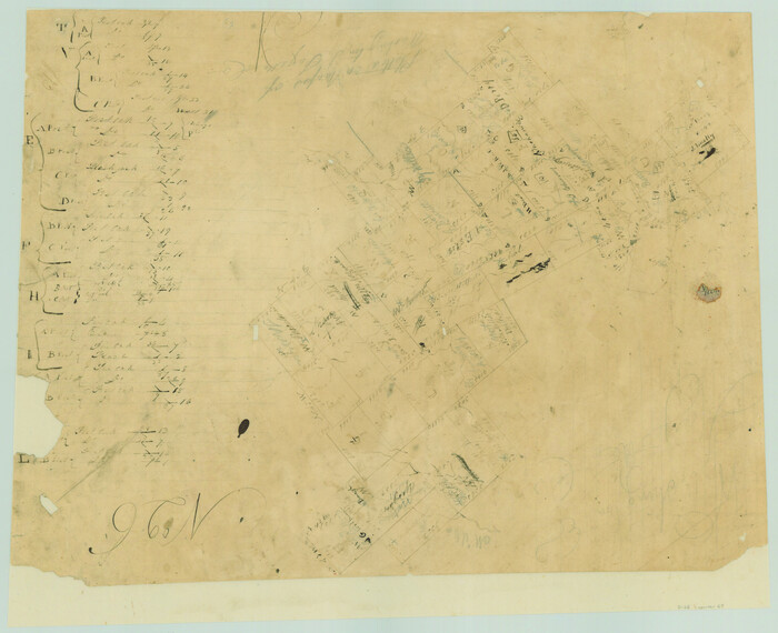
Lee County Rolled Sketch 1

Print $40.00
- Digital $50.00
Lee County Rolled Sketch 1
1939
Size: 71.0 x 42.4 inches
10739
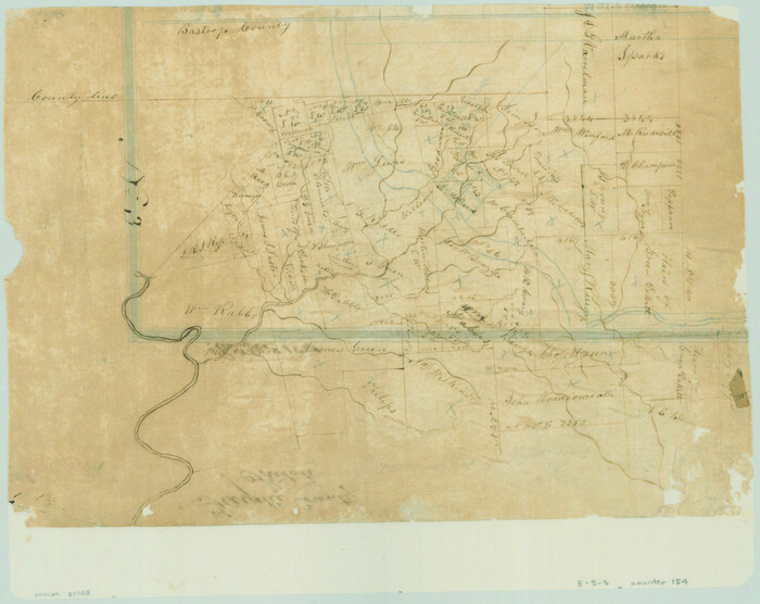
[Surveys along Rabb's Creek]
Print $2.00
- Digital $50.00
[Surveys along Rabb's Creek]
1841
Size: 8.7 x 11.0 inches
154
Burleson County Sketch File 5

Print $4.00
- Digital $50.00
Burleson County Sketch File 5
Size: 12.9 x 8.3 inches
16649
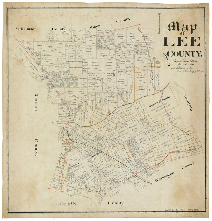
Map of Lee County

Print $20.00
- Digital $50.00
Map of Lee County
1888
Size: 42.1 x 39.8 inches
16876
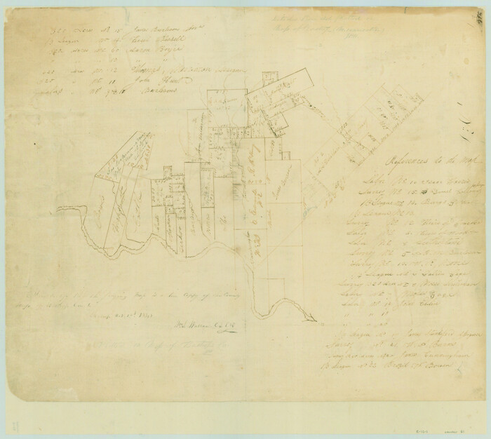
[Surveys in Austin's Colony along the San Antonio Road and the Brazos and Yegua Rivers]
Print $20.00
- Digital $50.00
[Surveys in Austin's Colony along the San Antonio Road and the Brazos and Yegua Rivers]
1831
Size: 30.8 x 19.1 inches
203
Fayette County Sketch File 3

Print $6.00
- Digital $50.00
Fayette County Sketch File 3
1863
Size: 8.3 x 10.7 inches
22501
Lee County Sketch File 1

Print $4.00
- Digital $50.00
Lee County Sketch File 1
1856
Size: 13.1 x 8.2 inches
29678
Lee County Sketch File 2

Print $4.00
- Digital $50.00
Lee County Sketch File 2
Size: 12.7 x 8.3 inches
29680
Lee County Sketch File 4

Print $4.00
- Digital $50.00
Lee County Sketch File 4
1859
Size: 9.5 x 8.1 inches
29682
Lee County Sketch File 4a

Print $4.00
- Digital $50.00
Lee County Sketch File 4a
1860
Size: 12.9 x 8.2 inches
29684
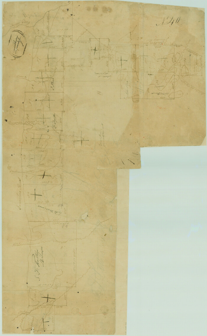
Lee County Sketch File 5

Print $40.00
- Digital $50.00
Lee County Sketch File 5
Size: 12.2 x 15.8 inches
29686
Lee County Sketch File 7

Print $36.00
- Digital $50.00
Lee County Sketch File 7
1838
Size: 3.6 x 3.5 inches
29688
Lee County Sketch File 8

Print $6.00
- Digital $50.00
Lee County Sketch File 8
1838
Size: 12.8 x 8.3 inches
29706
Lee County Sketch File 9

Print $4.00
- Digital $50.00
Lee County Sketch File 9
Size: 8.8 x 8.2 inches
29709
Map of Lee County

Print $20.00
- Digital $50.00
Map of Lee County
1874
Size: 22.4 x 18.6 inches
3805
Map of Lee County Texas

Print $20.00
- Digital $50.00
Map of Lee County Texas
1879
Size: 26.2 x 18.0 inches
4578
Map of Lee County
Print $20.00
- Digital $50.00
Map of Lee County
1888
Size: 41.6 x 40.1 inches
5013
Map of Lee County, Texas

Print $20.00
- Digital $50.00
Map of Lee County, Texas
1879
Size: 25.7 x 19.8 inches
562
Lee County Boundary File 2

Print $25.00
- Digital $50.00
Lee County Boundary File 2
Size: 14.2 x 8.6 inches
56269
[Surveys along the Colorado River]
Print $20.00
- Digital $50.00
[Surveys along the Colorado River]
1841
Size: 14.4 x 16.1 inches
61
Hicks, Station Map-Tracks & Structures Lands, San Antonio & Aransas Pass Railway Co.

Print $4.00
- Digital $50.00
Hicks, Station Map-Tracks & Structures Lands, San Antonio & Aransas Pass Railway Co.
1919
Size: 11.7 x 18.6 inches
62568
Tanglewood, Station Map-Tracks & Structures-Lands, San Antonio & Aransas Pass Railway Co., Station 4804+179 to Station 4856+179

Print $4.00
- Digital $50.00
Tanglewood, Station Map-Tracks & Structures-Lands, San Antonio & Aransas Pass Railway Co., Station 4804+179 to Station 4856+179
1919
Size: 11.7 x 18.6 inches
62569
San Antonio and Aransas Pass Ry. from Survey Station 4852+100 to Survey Station 5280+00

Print $4.00
- Digital $50.00
San Antonio and Aransas Pass Ry. from Survey Station 4852+100 to Survey Station 5280+00
Size: 11.8 x 18.6 inches
62570
Right of Way & Track Map, San Antonio & Aransas Pass Railway Co.

Print $40.00
- Digital $50.00
Right of Way & Track Map, San Antonio & Aransas Pass Railway Co.
1919
Size: 25.2 x 56.8 inches
64218
Houston & Texas Central Railway Through Bastrop County

Print $20.00
- Digital $50.00
Houston & Texas Central Railway Through Bastrop County
1916
Size: 21.3 x 41.6 inches
64419
Lee County Rolled Sketch 2

Print $20.00
- Digital $50.00
Lee County Rolled Sketch 2
1976
Size: 25.9 x 34.4 inches
6593
[Surveys in Austin's Colony along the Yegua River and Cedar Creek]
Print $20.00
- Digital $50.00
[Surveys in Austin's Colony along the Yegua River and Cedar Creek]
1835
Size: 15.7 x 19.3 inches
67
Burleson County Working Sketch 4

Print $20.00
- Digital $50.00
Burleson County Working Sketch 4
1979
Size: 33.3 x 35.6 inches
67723
Lee County Rolled Sketch 1
Print $40.00
- Digital $50.00
Lee County Rolled Sketch 1
1939
-
Size
71.0 x 42.4 inches
-
Map/Doc
10739
-
Creation Date
1939
[Surveys along Rabb's Creek]
Print $2.00
- Digital $50.00
[Surveys along Rabb's Creek]
1841
-
Size
8.7 x 11.0 inches
-
Map/Doc
154
-
Creation Date
1841
Burleson County Sketch File 5
Print $4.00
- Digital $50.00
Burleson County Sketch File 5
-
Size
12.9 x 8.3 inches
-
Map/Doc
16649
Map of Lee County
Print $20.00
- Digital $50.00
Map of Lee County
1888
-
Size
42.1 x 39.8 inches
-
Map/Doc
16876
-
Creation Date
1888
Lee County

Print $20.00
- Digital $50.00
Lee County
1945
-
Size
39.7 x 45.4 inches
-
Map/Doc
1882
-
Creation Date
1945
[Surveys in Austin's Colony along the San Antonio Road and the Brazos and Yegua Rivers]
Print $20.00
- Digital $50.00
[Surveys in Austin's Colony along the San Antonio Road and the Brazos and Yegua Rivers]
1831
-
Size
30.8 x 19.1 inches
-
Map/Doc
203
-
Creation Date
1831
Map of Giddings

Print $20.00
- Digital $50.00
Map of Giddings
1940
-
Size
16.5 x 21.2 inches
-
Map/Doc
2210
-
Creation Date
1940
Fayette County Sketch File 3
Print $6.00
- Digital $50.00
Fayette County Sketch File 3
1863
-
Size
8.3 x 10.7 inches
-
Map/Doc
22501
-
Creation Date
1863
Lee County Sketch File 1
Print $4.00
- Digital $50.00
Lee County Sketch File 1
1856
-
Size
13.1 x 8.2 inches
-
Map/Doc
29678
-
Creation Date
1856
Lee County Sketch File 2
Print $4.00
- Digital $50.00
Lee County Sketch File 2
-
Size
12.7 x 8.3 inches
-
Map/Doc
29680
Lee County Sketch File 4
Print $4.00
- Digital $50.00
Lee County Sketch File 4
1859
-
Size
9.5 x 8.1 inches
-
Map/Doc
29682
-
Creation Date
1859
Lee County Sketch File 4a
Print $4.00
- Digital $50.00
Lee County Sketch File 4a
1860
-
Size
12.9 x 8.2 inches
-
Map/Doc
29684
-
Creation Date
1860
Lee County Sketch File 5
Print $40.00
- Digital $50.00
Lee County Sketch File 5
-
Size
12.2 x 15.8 inches
-
Map/Doc
29686
Lee County Sketch File 7
Print $36.00
- Digital $50.00
Lee County Sketch File 7
1838
-
Size
3.6 x 3.5 inches
-
Map/Doc
29688
-
Creation Date
1838
Lee County Sketch File 8
Print $6.00
- Digital $50.00
Lee County Sketch File 8
1838
-
Size
12.8 x 8.3 inches
-
Map/Doc
29706
-
Creation Date
1838
Lee County Sketch File 9
Print $4.00
- Digital $50.00
Lee County Sketch File 9
-
Size
8.8 x 8.2 inches
-
Map/Doc
29709
Map of Lee County
Print $20.00
- Digital $50.00
Map of Lee County
1874
-
Size
22.4 x 18.6 inches
-
Map/Doc
3805
-
Creation Date
1874
Map of Lee County Texas
Print $20.00
- Digital $50.00
Map of Lee County Texas
1879
-
Size
26.2 x 18.0 inches
-
Map/Doc
4578
-
Creation Date
1879
Map of Lee County
Print $20.00
- Digital $50.00
Map of Lee County
1888
-
Size
41.6 x 40.1 inches
-
Map/Doc
5013
-
Creation Date
1888
Map of Lee County, Texas
Print $20.00
- Digital $50.00
Map of Lee County, Texas
1879
-
Size
25.7 x 19.8 inches
-
Map/Doc
562
-
Creation Date
1879
Lee County Boundary File 2
Print $25.00
- Digital $50.00
Lee County Boundary File 2
-
Size
14.2 x 8.6 inches
-
Map/Doc
56269
[Surveys along the Colorado River]
Print $20.00
- Digital $50.00
[Surveys along the Colorado River]
1841
-
Size
14.4 x 16.1 inches
-
Map/Doc
61
-
Creation Date
1841
Hicks, Station Map-Tracks & Structures Lands, San Antonio & Aransas Pass Railway Co.
Print $4.00
- Digital $50.00
Hicks, Station Map-Tracks & Structures Lands, San Antonio & Aransas Pass Railway Co.
1919
-
Size
11.7 x 18.6 inches
-
Map/Doc
62568
-
Creation Date
1919
Tanglewood, Station Map-Tracks & Structures-Lands, San Antonio & Aransas Pass Railway Co., Station 4804+179 to Station 4856+179
Print $4.00
- Digital $50.00
Tanglewood, Station Map-Tracks & Structures-Lands, San Antonio & Aransas Pass Railway Co., Station 4804+179 to Station 4856+179
1919
-
Size
11.7 x 18.6 inches
-
Map/Doc
62569
-
Creation Date
1919
San Antonio and Aransas Pass Ry. from Survey Station 4852+100 to Survey Station 5280+00
Print $4.00
- Digital $50.00
San Antonio and Aransas Pass Ry. from Survey Station 4852+100 to Survey Station 5280+00
-
Size
11.8 x 18.6 inches
-
Map/Doc
62570
Right of Way & Track Map, San Antonio & Aransas Pass Railway Co.
Print $40.00
- Digital $50.00
Right of Way & Track Map, San Antonio & Aransas Pass Railway Co.
1919
-
Size
25.2 x 56.8 inches
-
Map/Doc
64218
-
Creation Date
1919
Houston & Texas Central Railway Through Bastrop County
Print $20.00
- Digital $50.00
Houston & Texas Central Railway Through Bastrop County
1916
-
Size
21.3 x 41.6 inches
-
Map/Doc
64419
-
Creation Date
1916
Lee County Rolled Sketch 2
Print $20.00
- Digital $50.00
Lee County Rolled Sketch 2
1976
-
Size
25.9 x 34.4 inches
-
Map/Doc
6593
-
Creation Date
1976
[Surveys in Austin's Colony along the Yegua River and Cedar Creek]
Print $20.00
- Digital $50.00
[Surveys in Austin's Colony along the Yegua River and Cedar Creek]
1835
-
Size
15.7 x 19.3 inches
-
Map/Doc
67
-
Creation Date
1835
Burleson County Working Sketch 4
Print $20.00
- Digital $50.00
Burleson County Working Sketch 4
1979
-
Size
33.3 x 35.6 inches
-
Map/Doc
67723
-
Creation Date
1979