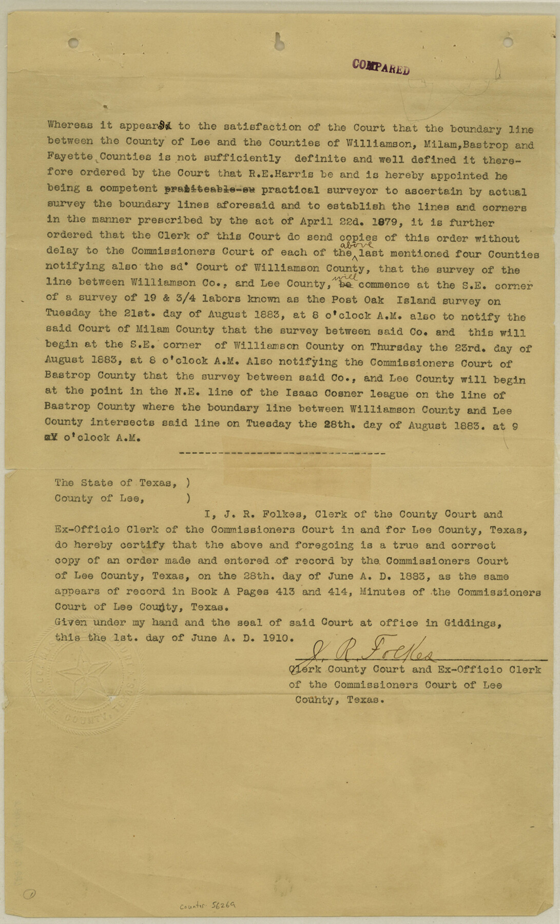
Lee County Boundary File 2
[Fieldnotes of the Boundary line between Lee and Milam Counties, Lee and Williamson Counties, Lee and Bastrop Counties and Lee and Fayette Counties]
-
Map/Doc
56269
-
Collection
General Map Collection
-
Counties
Lee
-
Subjects
County Boundaries
-
Height x Width
14.2 x 8.6 inches
36.1 x 21.8 cm
Part of: General Map Collection
Texas 1971 Official State Highway Map

Digital $50.00
Texas 1971 Official State Highway Map
Size 27.9 x 36.3 inches
Map/Doc 94315
Lampasas County Sketch File 21

Print $14.00
- Digital $50.00
Lampasas County Sketch File 21
2001
Size 14.2 x 8.8 inches
Map/Doc 29436
Kleberg County Aerial Photograph Index Sheet 4

Print $20.00
- Digital $50.00
Kleberg County Aerial Photograph Index Sheet 4
1956
Size 19.3 x 23.3 inches
Map/Doc 83721
Real County Rolled Sketch 7

Print $20.00
- Digital $50.00
Real County Rolled Sketch 7
Size 24.5 x 29.9 inches
Map/Doc 7457
Township No. 5 South Range No. 9 West of the Indian Meridian

Print $20.00
- Digital $50.00
Township No. 5 South Range No. 9 West of the Indian Meridian
1874
Size 19.2 x 24.4 inches
Map/Doc 75167
Wheeler County Sketch File 8

Print $6.00
- Digital $50.00
Wheeler County Sketch File 8
1935
Size 11.4 x 8.8 inches
Map/Doc 40005
Red River County Working Sketch 73

Print $20.00
- Digital $50.00
Red River County Working Sketch 73
1979
Size 17.0 x 19.2 inches
Map/Doc 72056
Smith County Rolled Sketch 6A1

Print $40.00
- Digital $50.00
Smith County Rolled Sketch 6A1
Size 49.2 x 38.6 inches
Map/Doc 10704
Swisher County Boundary File 1

Print $72.00
- Digital $50.00
Swisher County Boundary File 1
Size 9.0 x 4.5 inches
Map/Doc 59075
Reeves County Working Sketch 62

Print $20.00
- Digital $50.00
Reeves County Working Sketch 62
1984
Size 29.5 x 35.4 inches
Map/Doc 63505
Floyd County Sketch File 28

Print $20.00
- Digital $50.00
Floyd County Sketch File 28
Size 17.4 x 18.6 inches
Map/Doc 11487
Map of Concho County

Print $20.00
- Digital $50.00
Map of Concho County
1862
Size 21.7 x 18.2 inches
Map/Doc 3435
You may also like
Coke County Working Sketch 24

Print $20.00
- Digital $50.00
Coke County Working Sketch 24
1956
Size 28.7 x 31.1 inches
Map/Doc 68061
Concho County Sketch File 25

Print $8.00
- Digital $50.00
Concho County Sketch File 25
1885
Size 11.4 x 9.0 inches
Map/Doc 19155
Eastland County Sketch File 22

Print $33.00
- Digital $50.00
Eastland County Sketch File 22
1964
Size 11.0 x 17.0 inches
Map/Doc 21626
Plat of a survey of the North part of section 16, Block 362, Martha McBride, Presidio County, Texas

Print $20.00
- Digital $50.00
Plat of a survey of the North part of section 16, Block 362, Martha McBride, Presidio County, Texas
1989
Size 24.4 x 36.6 inches
Map/Doc 60522
The Land Offices. No. 9, Gonzales, December 22, 1836

Print $20.00
The Land Offices. No. 9, Gonzales, December 22, 1836
2020
Size 22.3 x 21.7 inches
Map/Doc 96422
Flight Mission No. DCL-7C, Frame 42, Kenedy County

Print $20.00
- Digital $50.00
Flight Mission No. DCL-7C, Frame 42, Kenedy County
1943
Size 15.3 x 15.2 inches
Map/Doc 86030
Topography of the Colorado River in the City of Austin

Print $4.00
- Digital $50.00
Topography of the Colorado River in the City of Austin
1941
Size 18.7 x 29.6 inches
Map/Doc 65326
Cottle County Sketch File 6a

Print $8.00
- Digital $50.00
Cottle County Sketch File 6a
Size 8.6 x 7.3 inches
Map/Doc 19476
Concho County Sketch File 10

Print $20.00
- Digital $50.00
Concho County Sketch File 10
1887
Size 23.1 x 33.8 inches
Map/Doc 11150
Parker County Working Sketch 2

Print $20.00
- Digital $50.00
Parker County Working Sketch 2
1920
Map/Doc 71452
Flight Mission No. BRE-1P, Frame 147, Nueces County

Print $20.00
- Digital $50.00
Flight Mission No. BRE-1P, Frame 147, Nueces County
1956
Size 18.5 x 22.3 inches
Map/Doc 86707
Map of Texas in 1830 Showing Spanish Colonies

Print $20.00
- Digital $50.00
Map of Texas in 1830 Showing Spanish Colonies
Size 41.1 x 42.0 inches
Map/Doc 73588