Smith County Rolled Sketch 6A1
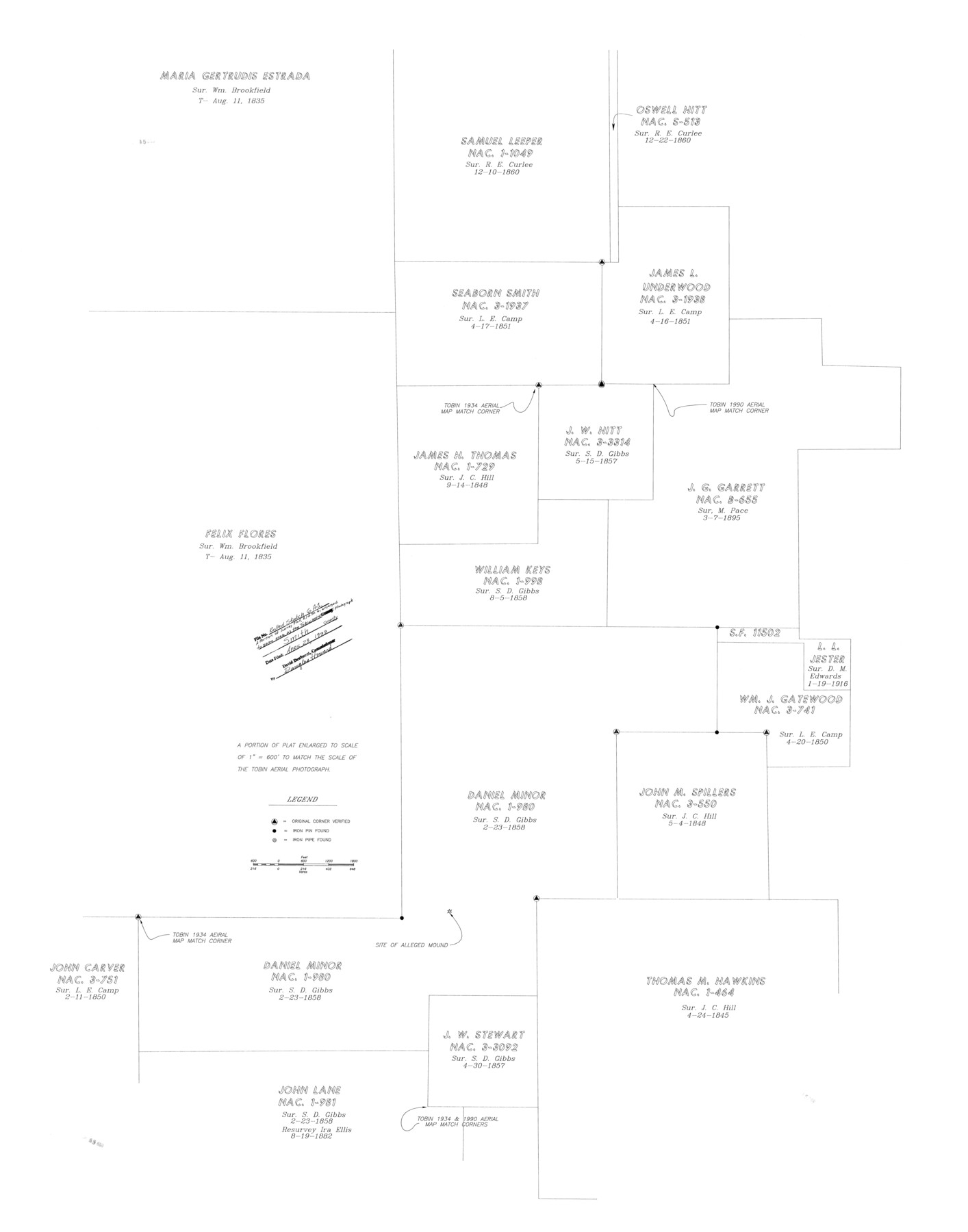
A portion of [Smith County Rolled Sketch 6] enlarged to scale of 1" = 600 feet to match the scale of the Tobin Aerial Photograph [Smith County Rolled Sketch 6A2]
-
Map/Doc
10704
-
Collection
General Map Collection
-
Object Dates
1999/4/23 (File Date)
-
Counties
Smith
-
Subjects
Surveying Rolled Sketch
-
Height x Width
49.2 x 38.6 inches
125.0 x 98.0 cm
-
Scale
1" = 600 feet
-
Comments
See Smith County Rolled Sketch 6 (10699) for related plat and see Smith County Rolled Sketch 6A2 (10702) and Smith County Rolled Sketch 6A3 (10698) for aerial photos.
Related maps
Smith County Rolled Sketch 6A3

Print $40.00
- Digital $50.00
Smith County Rolled Sketch 6A3
1990
Size 48.6 x 36.8 inches
Map/Doc 10698
Smith County Rolled Sketch 6

Print $20.00
- Digital $50.00
Smith County Rolled Sketch 6
1999
Size 43.3 x 30.0 inches
Map/Doc 10699
Smith County Rolled Sketch 6A2

Print $40.00
- Digital $50.00
Smith County Rolled Sketch 6A2
1934
Size 48.7 x 36.7 inches
Map/Doc 10702
Part of: General Map Collection
Marion County Rolled Sketch JMR

Print $20.00
- Digital $50.00
Marion County Rolled Sketch JMR
1954
Size 36.6 x 39.3 inches
Map/Doc 9489
Atascosa County Rolled Sketch 7

Print $20.00
- Digital $50.00
Atascosa County Rolled Sketch 7
1913
Size 26.1 x 26.7 inches
Map/Doc 5092
The Texas and Pacific Ry. Co., Station Map, Roscoe, Texas

Print $20.00
- Digital $50.00
The Texas and Pacific Ry. Co., Station Map, Roscoe, Texas
Size 11.0 x 19.0 inches
Map/Doc 64690
Travis County Sketch File 32

Print $20.00
- Digital $50.00
Travis County Sketch File 32
Size 25.3 x 32.7 inches
Map/Doc 12460
Kinney County

Print $40.00
- Digital $50.00
Kinney County
1955
Size 50.5 x 47.0 inches
Map/Doc 73209
Map of Brazoria

Print $20.00
- Digital $50.00
Map of Brazoria
1860
Size 18.2 x 23.6 inches
Map/Doc 4509
Jack County Sketch File 12

Print $9.00
- Digital $50.00
Jack County Sketch File 12
Size 5.6 x 8.3 inches
Map/Doc 27533

Jalisco Banco Number 67, cut from Mexico in 1909

Print $3.00
- Digital $50.00
Jalisco Banco Number 67, cut from Mexico in 1909
1912
Size 14.2 x 11.2 inches
Map/Doc 2064
Jim Hogg County Working Sketch 1

Print $20.00
- Digital $50.00
Jim Hogg County Working Sketch 1
1933
Size 30.4 x 25.3 inches
Map/Doc 66587
Nueces County NRC Article 33.136 Sketch 10

Print $36.00
- Digital $50.00
Nueces County NRC Article 33.136 Sketch 10
2004
Size 23.9 x 35.9 inches
Map/Doc 83526
Refugio County Sketch File 8b

Print $4.00
- Digital $50.00
Refugio County Sketch File 8b
1876
Size 8.5 x 10.5 inches
Map/Doc 35254
You may also like
Hutchinson County Sketch File 52

Print $14.00
- Digital $50.00
Hutchinson County Sketch File 52
1992
Size 14.2 x 8.8 inches
Map/Doc 27449
San Jacinto County

Print $20.00
- Digital $50.00
San Jacinto County
1942
Size 47.1 x 42.8 inches
Map/Doc 63017
The Land Offices. No. 3, Liberty, December 22, 1836

Print $20.00
The Land Offices. No. 3, Liberty, December 22, 1836
2020
Size 16.0 x 21.7 inches
Map/Doc 96416
Map of Robertson County

Print $40.00
- Digital $50.00
Map of Robertson County
1840
Size 59.4 x 38.6 inches
Map/Doc 4655
Orange County Sketch File 24

Print $6.00
- Digital $50.00
Orange County Sketch File 24
Size 8.9 x 15.7 inches
Map/Doc 33353
Jasper County Rolled Sketch 7B

Print $20.00
- Digital $50.00
Jasper County Rolled Sketch 7B
Size 19.7 x 11.6 inches
Map/Doc 6355

[Sketch for Mineral Application 1112 - Colorado River, H. E. Chambers]
![65642, [Sketch for Mineral Application 1112 - Colorado River, H. E. Chambers], General Map Collection](https://historictexasmaps.com/wmedia_w700/maps/65642.tif.jpg)
Print $20.00
- Digital $50.00
[Sketch for Mineral Application 1112 - Colorado River, H. E. Chambers]
1918
Size 17.1 x 28.4 inches
Map/Doc 65642
Runnels County Rolled Sketch 48

Print $20.00
- Digital $50.00
Runnels County Rolled Sketch 48
Size 32.4 x 36.7 inches
Map/Doc 7533
Coke County Sketch File 9

Print $4.00
- Digital $50.00
Coke County Sketch File 9
Size 12.6 x 7.9 inches
Map/Doc 18585
[Block S, Sections 4 and 11]
![92834, [Block S, Sections 4 and 11], Twichell Survey Records](https://historictexasmaps.com/wmedia_w700/maps/92834-1.tif.jpg)
Print $20.00
- Digital $50.00
[Block S, Sections 4 and 11]
1951
Size 14.8 x 12.2 inches
Map/Doc 92834
