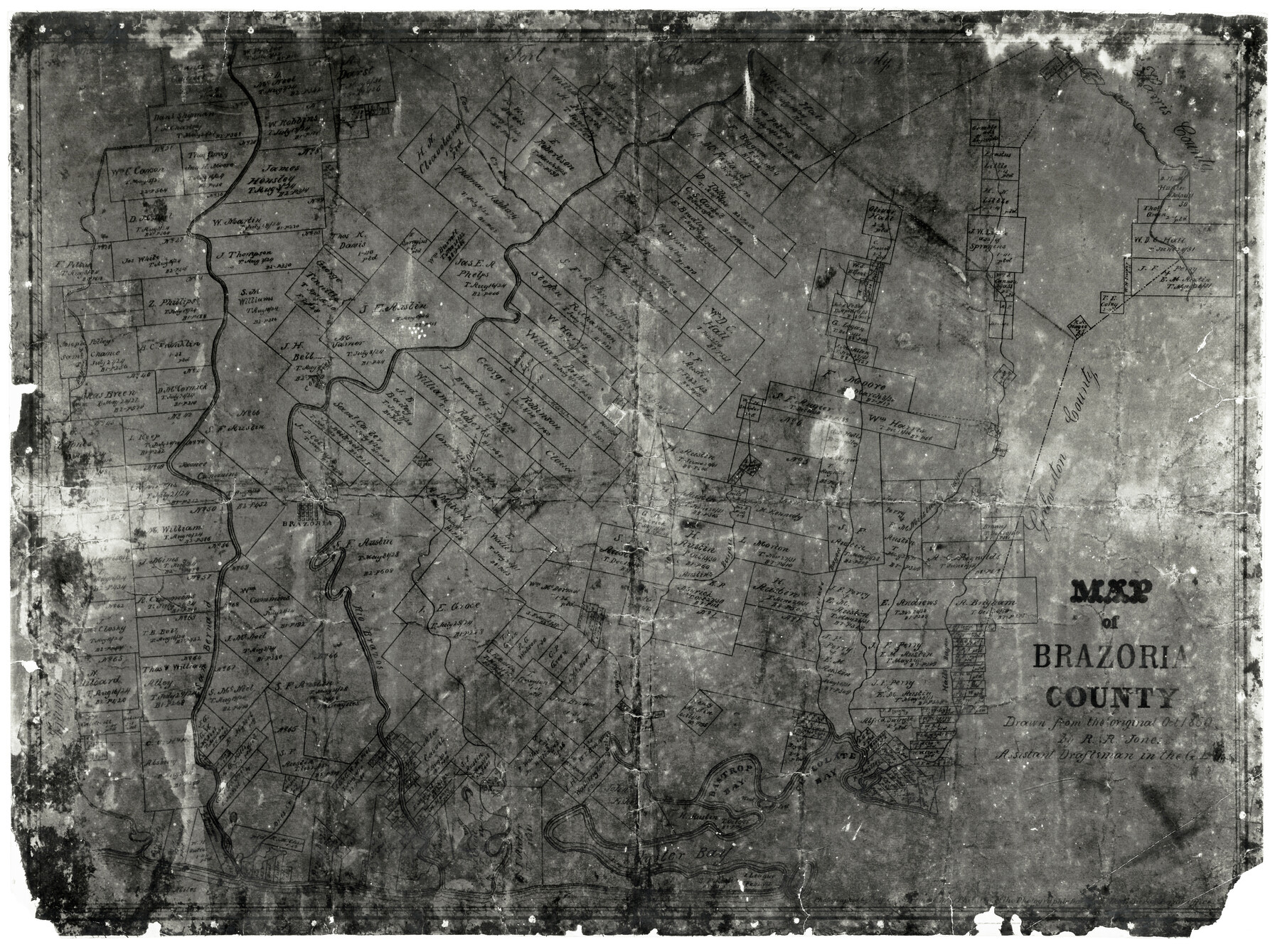
Map of Brazoria
- 
                          Map/Doc4509
- 
                            CollectionGeneral Map Collection
- 
                            Object Dates10/1860 (Creation Date)
- 
                            People and OrganizationsR.R. Jones (Draftsman)C.C. Stremme (Draftsman)
- 
                            CountiesBrazoria
- 
                            SubjectsCounty
- 
                            Height x Width18.2 x 23.6 inches46.2 x 59.9 cm
- 
                            CommentsNote on map: "Drawn from the original October 1860". Refer to counter number 856 for better copy.
- 
                            FeaturesAustin's BayouOyster BayBastrop BayUnion CreekJones CreekBastrop BayouChocolate BayHalls BayouChocolate BayouCow CreekRio BravoSan Bernard RiverBrazoriaOyster CreekMustang BayouColumbiaClear Creek
Part of: General Map Collection
            Zapata County Working Sketch 20


                                            Print $20.00                    
                                             -                         Digital $50.00                                    
                Zapata County Working Sketch 20
1979
Size 20.9 x 18.5 inches
                                Map/Doc 62071
            
            Brazoria County Working Sketch 32


                                            Print $20.00                    
                                             -                         Digital $50.00                                    
                Brazoria County Working Sketch 32
1979
Size 15.8 x 36.9 inches
                                Map/Doc 67517
            
            Cochran County Rolled Sketch 2


                                            Print $20.00                    
                                             -                         Digital $50.00                                    
                Cochran County Rolled Sketch 2
1940
Size 27.7 x 33.9 inches
                                Map/Doc 5500
            
            Brewster County Sketch File N-3


                                            Print $6.00                    
                                             -                         Digital $50.00                                    
                Brewster County Sketch File N-3
1882
Size 8.6 x 7.6 inches
                                Map/Doc 15589
            
            S. M. S. Flat Top Ranch


                                            Print $6.00                    
                                             -                         Digital $50.00                                    
                S. M. S. Flat Top Ranch
1955
Size 23.2 x 32.8 inches
                                Map/Doc 2102
            
            McCulloch County Rolled Sketch 4


                                            Print $40.00                    
                                             -                         Digital $50.00                                    
                McCulloch County Rolled Sketch 4
1901
Size 48.4 x 14.1 inches
                                Map/Doc 9498
            
            Kimble County Working Sketch 83


                                            Print $6.00                    
                                             -                         Digital $50.00                                    
                Kimble County Working Sketch 83
1971
Size 31.3 x 31.1 inches
                                Map/Doc 70151
            
            Brown County Working Sketch 6


                                            Print $20.00                    
                                             -                         Digital $50.00                                    
                Brown County Working Sketch 6
1948
Size 12.9 x 19.3 inches
                                Map/Doc 67771
            
            Motley County Sketch File 30 (S)


                                            Print $40.00                    
                                             -                         Digital $50.00                                    
                Motley County Sketch File 30 (S)
1905
Size 16.1 x 17.1 inches
                                Map/Doc 42147
            
            Gulf of Mexico


                                            Print $20.00                    
                                             -                         Digital $50.00                                    
                Gulf of Mexico
1908
Size 18.4 x 27.9 inches
                                Map/Doc 72662
            
            Panola County Sketch File 28


                                            Print $20.00                    
                                             -                         Digital $50.00                                    
                Panola County Sketch File 28
1859
Size 22.8 x 22.2 inches
                                Map/Doc 12142
            You may also like
            Boundary and Ownership map, Laguna Atascosa National Wildlife Refuge, Cameron and Willacy Counties, Texas


                                            Print $40.00                    
                                             -                         Digital $50.00                                    
                Boundary and Ownership map, Laguna Atascosa National Wildlife Refuge, Cameron and Willacy Counties, Texas
1968
Size 73.9 x 43.2 inches
                                Map/Doc 60395
            
            San Jacinto County Rolled Sketch 8


                                            Print $20.00                    
                                             -                         Digital $50.00                                    
                San Jacinto County Rolled Sketch 8
1940
Size 33.6 x 35.1 inches
                                Map/Doc 7559
            
            [Sketch showing I. & G. N. Block 8]
            
                                    ![91715, [Sketch showing I. & G. N. Block 8], Twichell Survey Records](https://historictexasmaps.com/wmedia_w700/maps/91715-1.tif.jpg) 


    ![91715, [Sketch showing I. & G. N. Block 8], Twichell Survey Records](https://historictexasmaps.com/wmedia_w700/maps/91715-1.tif.jpg) 
                                
            
                                            Print $2.00                    
                                             -                         Digital $50.00                                    
                [Sketch showing I. & G. N. Block 8]
1919
Size 7.7 x 10.3 inches
                                Map/Doc 91715
            
            [Surveys along San Cristoval Creek]
            
                                    ![300, [Surveys along San Cristoval Creek], General Map Collection](https://historictexasmaps.com/wmedia_w700/maps/300.tif.jpg) 


    ![300, [Surveys along San Cristoval Creek], General Map Collection](https://historictexasmaps.com/wmedia_w700/maps/300.tif.jpg) 
                                
            
                                            Print $2.00                    
                                             -                         Digital $50.00                                    
                [Surveys along San Cristoval Creek]
1842
Size 9.0 x 9.3 inches
                                Map/Doc 300
            
            Eastland County


                                            Print $20.00                    
                                             -                         Digital $50.00                                    
                Eastland County
1945
Size 42.8 x 42.5 inches
                                Map/Doc 73136
            
            Map of Prison Properties in Vicinity of Huntsville, Walker County, Texas


                                            Print $20.00                    
                                             -                         Digital $50.00                                    
                Map of Prison Properties in Vicinity of Huntsville, Walker County, Texas
1933
Size 36.6 x 43.0 inches
                                Map/Doc 62992
            
            Presidio County Working Sketch 89


                                            Print $20.00                    
                                             -                         Digital $50.00                                    
                Presidio County Working Sketch 89
1972
Size 28.8 x 37.5 inches
                                Map/Doc 71766
            
            Anderson County Working Sketch 20


                                            Print $20.00                    
                                             -                         Digital $50.00                                    
                Anderson County Working Sketch 20
1952
Size 23.1 x 20.6 inches
                                Map/Doc 67020
            
            Chambers County Sketch File 55


                                            Print $10.00                    
                                             -                         Digital $50.00                                    
                Chambers County Sketch File 55
1935
Size 14.3 x 8.6 inches
                                Map/Doc 18094
            
            Travis County Boundary File 6


                                            Print $109.00                    
                                             -                         Digital $50.00                                    
                Travis County Boundary File 6
Size 14.6 x 9.1 inches
                                Map/Doc 59433
            
            Flight Mission No. BRE-1P, Frame 31, Nueces County


                                            Print $20.00                    
                                             -                         Digital $50.00                                    
                Flight Mission No. BRE-1P, Frame 31, Nueces County
1956
Size 18.0 x 21.6 inches
                                Map/Doc 86627
            
            Crockett County Working Sketch 71


                                            Print $20.00                    
                                             -                         Digital $50.00                                    
                Crockett County Working Sketch 71
1963
Size 38.7 x 32.7 inches
                                Map/Doc 68404
             
                        ![94196, New Mexico [Recto], General Map Collection](https://historictexasmaps.com/wmedia_w700/maps/94196.tif.jpg)