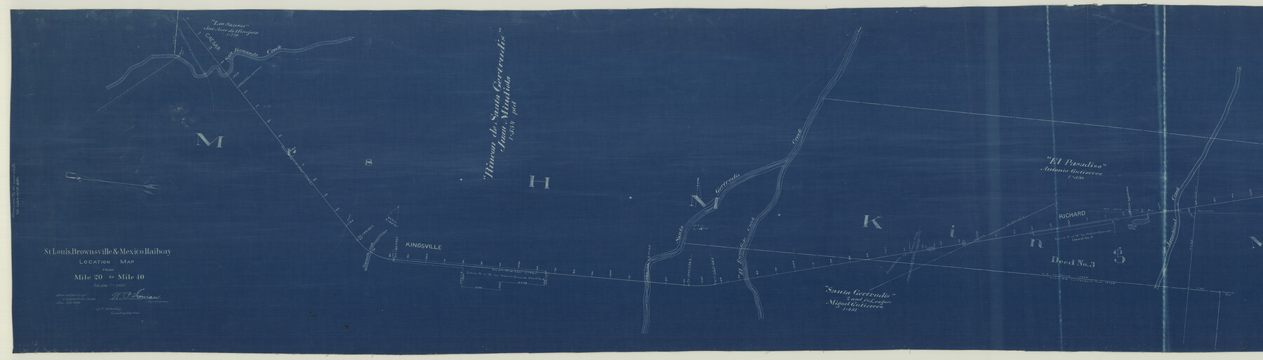
St. Louis, Brownsville & Mexico Railway Location Map from Mile 20 to Mile 40
Z-2-21
-
Map/Doc
64077
-
Collection
General Map Collection
-
Object Dates
1906/12/30 (Creation Date)
-
People and Organizations
Office of Chief Engineer (Publisher)
W. O. Homan (Surveyor/Engineer)
J. F. Hinckley (Surveyor/Engineer)
-
Counties
Cameron
-
Subjects
Railroads
-
Height x Width
19.3 x 67.5 inches
49.0 x 171.5 cm
-
Medium
blueprint/diazo
-
Scale
1" = 1000 feet
-
Comments
Segment 1. See counter no. 64076 for segment 2.
See counter 89280 for digital composite.
See counter nos. 64077 through 64080 for other related sheets and counters 89281 and 89282 for related digital composites. -
Features
SLB&M
Caesar
San Fernando Creek
Corpus Christi and Santa Gertrudis Road
Corpus Christi Road
Santa Gertrudis Road
Tranquites Creek
Kingsville
El Escondido Creek
Santa Gertrudis Creek
Santa Gertrudis and Lapara Road
Lapara Road
Richard
Javachinal Creek
Part of: General Map Collection
Hardin County Sketch File Q-11

Print $20.00
- Digital $50.00
Hardin County Sketch File Q-11
1937
Size 19.9 x 23.8 inches
Map/Doc 11645
Bexar County Boundary File 3

Print $6.00
- Digital $50.00
Bexar County Boundary File 3
Size 8.2 x 3.6 inches
Map/Doc 50536
Current Miscellaneous File 24a

Print $8.00
- Digital $50.00
Current Miscellaneous File 24a
1949
Size 11.0 x 8.6 inches
Map/Doc 73893
Baylor County Sketch File 2

Print $10.00
- Digital $50.00
Baylor County Sketch File 2
Size 7.8 x 9.9 inches
Map/Doc 14119
[Sketch for Mineral Application 16787 - Pecos River Bed, A. T. Freet]
![65632, [Sketch for Mineral Application 16787 - Pecos River Bed, A. T. Freet], General Map Collection](https://historictexasmaps.com/wmedia_w700/maps/65632-1.tif.jpg)
Print $40.00
- Digital $50.00
[Sketch for Mineral Application 16787 - Pecos River Bed, A. T. Freet]
Size 70.8 x 18.9 inches
Map/Doc 65632
Jefferson County Rolled Sketch 52

Print $40.00
- Digital $50.00
Jefferson County Rolled Sketch 52
Size 28.2 x 52.9 inches
Map/Doc 9308
Bastrop County Working Sketch 8

Print $20.00
- Digital $50.00
Bastrop County Working Sketch 8
1937
Size 23.9 x 43.1 inches
Map/Doc 67308
[Travis District]
![88740, [Travis District], General Map Collection](https://historictexasmaps.com/wmedia_w700/maps/88740.tif.jpg)
Print $40.00
- Digital $50.00
[Travis District]
1840
Size 54.7 x 46.0 inches
Map/Doc 88740
Refugio County Working Sketch 18

Print $20.00
- Digital $50.00
Refugio County Working Sketch 18
2013
Size 24.0 x 29.3 inches
Map/Doc 93622
Kenedy County Rolled Sketch 4

Print $40.00
- Digital $50.00
Kenedy County Rolled Sketch 4
1904
Size 39.4 x 57.6 inches
Map/Doc 10654
Flight Mission No. BRA-7M, Frame 19, Jefferson County

Print $20.00
- Digital $50.00
Flight Mission No. BRA-7M, Frame 19, Jefferson County
1953
Size 18.8 x 22.4 inches
Map/Doc 85470
Baylor County Aerial Photograph Index Sheet 1

Print $20.00
- Digital $50.00
Baylor County Aerial Photograph Index Sheet 1
1950
Size 21.4 x 17.4 inches
Map/Doc 83663
You may also like
Galveston County Sketch File 74

Print $12.00
- Digital $50.00
Galveston County Sketch File 74
2002
Size 11.3 x 8.7 inches
Map/Doc 77526
Kleberg County Rolled Sketch 10-16

Print $20.00
- Digital $50.00
Kleberg County Rolled Sketch 10-16
1952
Size 37.0 x 33.2 inches
Map/Doc 9381
Hamilton County Boundary File 3

Print $52.00
- Digital $50.00
Hamilton County Boundary File 3
Size 14.2 x 8.8 inches
Map/Doc 54197
Jeff Davis County Sketch File 46

Print $8.00
- Digital $50.00
Jeff Davis County Sketch File 46
1906
Size 13.5 x 8.8 inches
Map/Doc 28080
Potter County Boundary File 4b

Print $20.00
- Digital $50.00
Potter County Boundary File 4b
Size 9.2 x 32.9 inches
Map/Doc 58012
Flight Mission No. CRC-3R, Frame 27, Chambers County

Print $20.00
- Digital $50.00
Flight Mission No. CRC-3R, Frame 27, Chambers County
1956
Size 18.7 x 22.3 inches
Map/Doc 84801
Pecos County Working Sketch 32
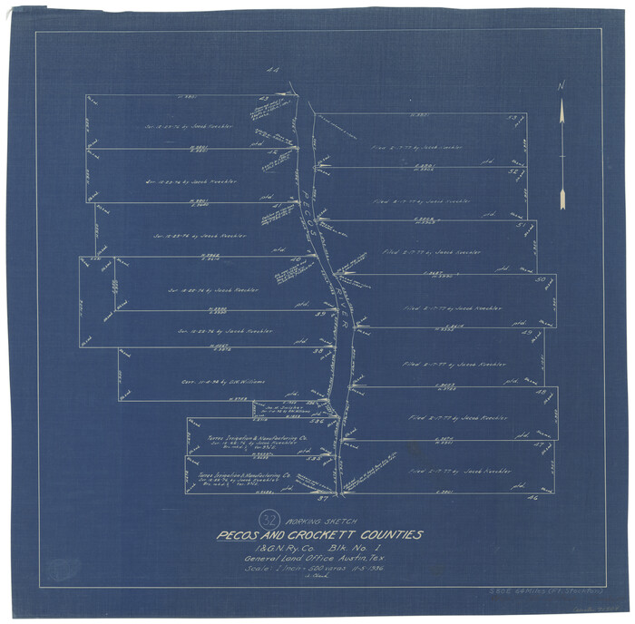
Print $20.00
- Digital $50.00
Pecos County Working Sketch 32
1936
Size 21.8 x 22.2 inches
Map/Doc 71504
Colorado River, Bull Creek Sheet[/Champion 125 Acre Tract]
![65323, Colorado River, Bull Creek Sheet[/Champion 125 Acre Tract], General Map Collection](https://historictexasmaps.com/wmedia_w700/maps/65323.tif.jpg)
Print $6.00
- Digital $50.00
Colorado River, Bull Creek Sheet[/Champion 125 Acre Tract]
1934
Size 19.3 x 32.0 inches
Map/Doc 65323
Maverick County Rolled Sketch 23

Print $91.00
- Digital $50.00
Maverick County Rolled Sketch 23
1965
Size 9.5 x 14.8 inches
Map/Doc 46786
Terrell County Working Sketch 84d

Print $20.00
- Digital $50.00
Terrell County Working Sketch 84d
1992
Size 18.4 x 31.5 inches
Map/Doc 69608
Culberson County Working Sketch 67

Print $40.00
- Digital $50.00
Culberson County Working Sketch 67
1975
Size 48.9 x 33.2 inches
Map/Doc 68521
Trinity County Sketch File 2

Print $36.00
- Digital $50.00
Trinity County Sketch File 2
1855
Size 10.3 x 8.2 inches
Map/Doc 38490