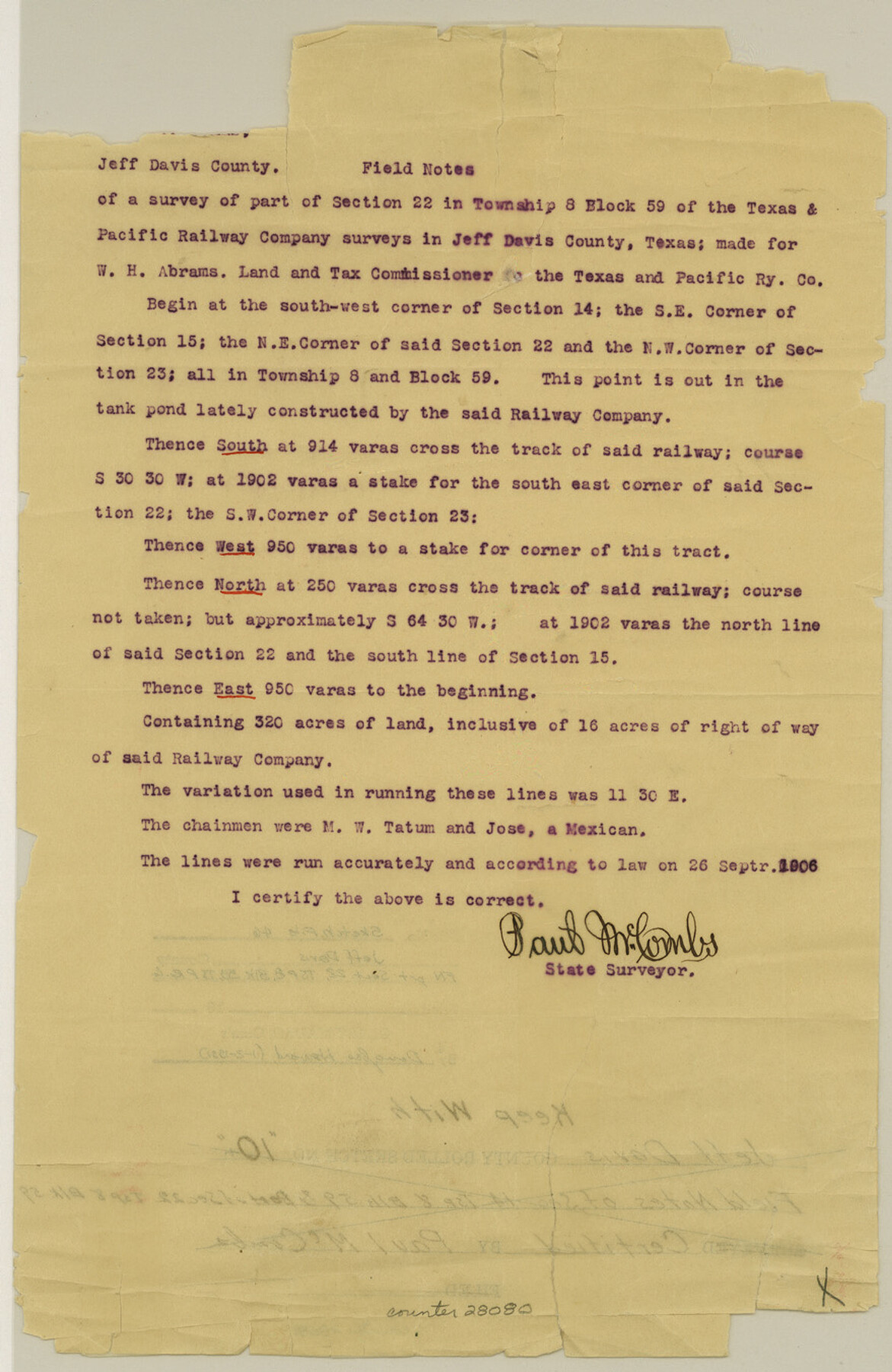
Jeff Davis County Sketch File 46
[Field notes of part of sections 14 and 22, Block 59, Township 8, T. & P. RR. Co.]
-
Map/Doc
28080
-
Collection
General Map Collection
-
Object Dates
8/26/1906 (Creation Date)
9/26/1906 (Survey Date)
-
People and Organizations
Paul McCombs (Surveyor/Engineer)
M.W. Tatum (Chainman)
Jose (Chainman)
-
Counties
Jeff Davis
-
Subjects
Surveying Sketch File
-
Height x Width
13.5 x 8.8 inches
34.3 x 22.4 cm
-
Medium
paper, print
-
Features
T&P
Part of: General Map Collection
Bastrop County

Print $20.00
- Digital $50.00
Bastrop County
1917
Size 45.5 x 40.8 inches
Map/Doc 66711
Grayson County

Print $20.00
- Digital $50.00
Grayson County
1935
Size 45.9 x 41.2 inches
Map/Doc 1844
Right of Way & Track Map, St. Louis, Brownsville & Mexico Ry. operated by St. Louis, Brownsville & Mexico Ry. Co.

Print $40.00
- Digital $50.00
Right of Way & Track Map, St. Louis, Brownsville & Mexico Ry. operated by St. Louis, Brownsville & Mexico Ry. Co.
1919
Size 25.5 x 57.1 inches
Map/Doc 64624
Carta Agricola

Print $20.00
- Digital $50.00
Carta Agricola
1897
Size 26.0 x 34.3 inches
Map/Doc 96804
Controlled Mosaic by Jack Amman Photogrammetric Engineers, Inc - Sheet 29

Print $20.00
- Digital $50.00
Controlled Mosaic by Jack Amman Photogrammetric Engineers, Inc - Sheet 29
1954
Size 20.0 x 24.0 inches
Map/Doc 83482
Castro County Sketch File 8

Print $20.00
- Digital $50.00
Castro County Sketch File 8
1908
Size 27.2 x 24.0 inches
Map/Doc 11060
Duval County Sketch File 76

Print $20.00
- Digital $50.00
Duval County Sketch File 76
1959
Size 15.1 x 27.3 inches
Map/Doc 11410
Andrews County Sketch File 17

Print $8.00
- Digital $50.00
Andrews County Sketch File 17
Size 11.1 x 8.6 inches
Map/Doc 12901
Val Verde County Working Sketch 3

Print $20.00
- Digital $50.00
Val Verde County Working Sketch 3
Size 17.5 x 24.1 inches
Map/Doc 72138
Flight Mission No. CGI-4N, Frame 182, Cameron County

Print $20.00
- Digital $50.00
Flight Mission No. CGI-4N, Frame 182, Cameron County
1955
Size 18.4 x 22.2 inches
Map/Doc 84685
Victoria County Working Sketch 5

Print $20.00
- Digital $50.00
Victoria County Working Sketch 5
1944
Size 35.2 x 40.8 inches
Map/Doc 72275
Atascosa County Working Sketch 13

Print $20.00
- Digital $50.00
Atascosa County Working Sketch 13
1929
Size 25.0 x 26.5 inches
Map/Doc 67209
You may also like
Hunt County Rolled Sketch 4

Print $209.00
- Digital $50.00
Hunt County Rolled Sketch 4
1959
Size 10.4 x 15.2 inches
Map/Doc 45992

Duval County Rolled Sketch 31

Print $20.00
- Digital $50.00
Duval County Rolled Sketch 31
1948
Size 21.9 x 20.8 inches
Map/Doc 5748
[Surveys along the Trinity River]
![350, [Surveys along the Trinity River], General Map Collection](https://historictexasmaps.com/wmedia_w700/maps/350.tif.jpg)
Print $20.00
- Digital $50.00
[Surveys along the Trinity River]
1846
Size 12.6 x 14.7 inches
Map/Doc 350
Aransas County Sketch File 3

Print $4.00
- Digital $50.00
Aransas County Sketch File 3
Size 8.0 x 12.7 inches
Map/Doc 13104
Sterling County Sketch File 12

Print $20.00
- Digital $50.00
Sterling County Sketch File 12
1930
Size 14.4 x 28.4 inches
Map/Doc 12358
Freestone County Working Sketch 8

Print $40.00
- Digital $50.00
Freestone County Working Sketch 8
1960
Size 60.6 x 36.6 inches
Map/Doc 69250

Matagorda County Working Sketch 8

Print $20.00
- Digital $50.00
Matagorda County Working Sketch 8
1953
Size 22.3 x 29.0 inches
Map/Doc 70866
Brooks County Boundary File 1

Print $54.00
- Digital $50.00
Brooks County Boundary File 1
Size 9.0 x 8.6 inches
Map/Doc 50809
Val Verde County Working Sketch 106

Print $20.00
- Digital $50.00
Val Verde County Working Sketch 106
1984
Size 30.4 x 40.8 inches
Map/Doc 72241
Limestone County Working Sketch 1

Print $20.00
- Digital $50.00
Limestone County Working Sketch 1
Size 15.4 x 13.0 inches
Map/Doc 70551