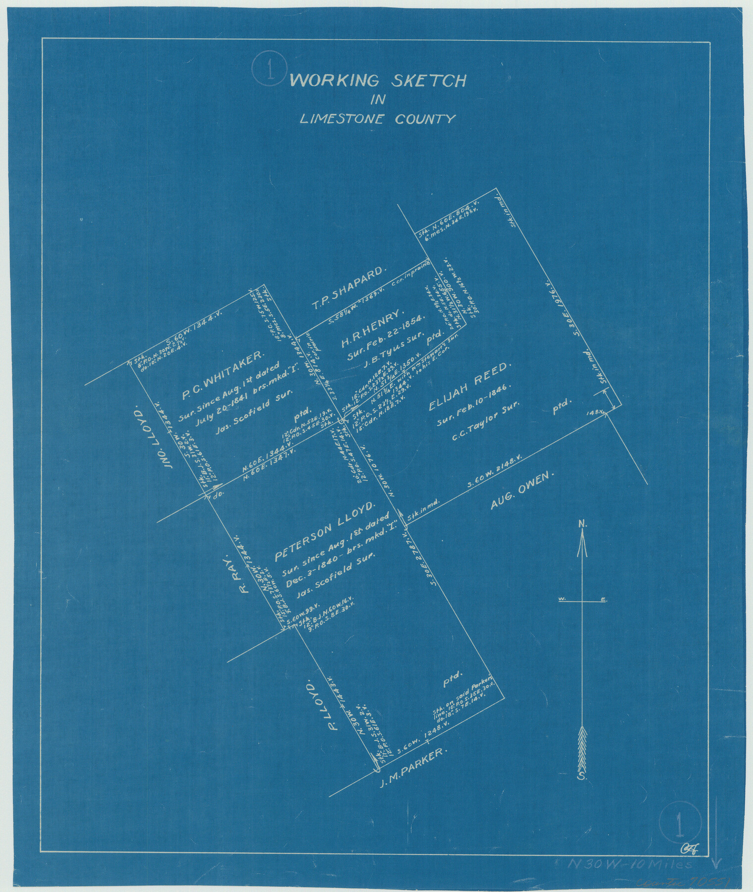
Limestone County Working Sketch 1
-
Map/Doc
70551
-
Collection
General Map Collection
-
Counties
Limestone
-
Subjects
Surveying Working Sketch
-
Height x Width
15.4 x 13.0 inches
39.1 x 33.0 cm
Part of: General Map Collection
Flight Mission No. DAG-24K, Frame 148, Matagorda County

Print $20.00
- Digital $50.00
Flight Mission No. DAG-24K, Frame 148, Matagorda County
1953
Size 18.5 x 22.2 inches
Map/Doc 86562
McCulloch County Working Sketch 8

Print $20.00
- Digital $50.00
McCulloch County Working Sketch 8
1977
Size 22.5 x 19.8 inches
Map/Doc 70683
Flight Mission No. DAG-23K, Frame 21, Matagorda County

Print $20.00
- Digital $50.00
Flight Mission No. DAG-23K, Frame 21, Matagorda County
1953
Size 18.4 x 22.3 inches
Map/Doc 86483
Map of Duval County

Print $20.00
- Digital $50.00
Map of Duval County
1875
Size 31.0 x 22.2 inches
Map/Doc 3496
Map of survey of the 100th Meridian west longitude, extending from the north bank of Red River to the intersection of the Northern Boundary of the Creek or Seminole Country

Print $40.00
- Digital $50.00
Map of survey of the 100th Meridian west longitude, extending from the north bank of Red River to the intersection of the Northern Boundary of the Creek or Seminole Country
Size 112.5 x 10.3 inches
Map/Doc 73565
Taylor County Rolled Sketch 27B

Print $20.00
- Digital $50.00
Taylor County Rolled Sketch 27B
Size 19.2 x 17.7 inches
Map/Doc 7920
Falls County Sketch File 2a

Print $2.00
- Digital $50.00
Falls County Sketch File 2a
1856
Size 8.4 x 10.9 inches
Map/Doc 22334
Crosby County Working Sketch 7

Print $20.00
- Digital $50.00
Crosby County Working Sketch 7
1938
Size 33.8 x 21.6 inches
Map/Doc 68441
United States, 1956 Revised Edition

Print $40.00
- Digital $50.00
United States, 1956 Revised Edition
1946
Size 48.0 x 36.3 inches
Map/Doc 78631
Trinity County Working Sketch 14

Print $20.00
- Digital $50.00
Trinity County Working Sketch 14
1956
Size 24.8 x 29.9 inches
Map/Doc 69463
Texas Pacific Land Trust, Preliminary Plat Blocks 64-65-66 Tsp. 7 & 8 T&P RR Co. Surveys

Print $40.00
- Digital $50.00
Texas Pacific Land Trust, Preliminary Plat Blocks 64-65-66 Tsp. 7 & 8 T&P RR Co. Surveys
1962
Size 54.6 x 43.0 inches
Map/Doc 87210
Callahan County Working Sketch 14

Print $20.00
- Digital $50.00
Callahan County Working Sketch 14
2010
Size 25.8 x 23.7 inches
Map/Doc 89273
You may also like
Duval County Rolled Sketch 38

Print $20.00
- Digital $50.00
Duval County Rolled Sketch 38
1937
Size 22.6 x 16.1 inches
Map/Doc 5755
Flight Mission No. CGI-3N, Frame 66, Cameron County

Print $20.00
- Digital $50.00
Flight Mission No. CGI-3N, Frame 66, Cameron County
1954
Size 18.6 x 22.1 inches
Map/Doc 84560
Tom Green County Sketch File 82

Print $20.00
- Digital $50.00
Tom Green County Sketch File 82
1888
Size 18.5 x 20.9 inches
Map/Doc 12454
Howard County Boundary File 1

Print $51.00
- Digital $50.00
Howard County Boundary File 1
Size 14.4 x 8.8 inches
Map/Doc 55086
Harris County Boundary File 39 (16)

Print $6.00
- Digital $50.00
Harris County Boundary File 39 (16)
Size 10.0 x 8.0 inches
Map/Doc 54354


San Augustine County Sketch File 7

Print $4.00
San Augustine County Sketch File 7
1858
Size 7.0 x 8.2 inches
Map/Doc 35646
El Nuevo Mexico y Tierras Adyacentes Mapa Levantado para la demarcacion de los Limites de los Dominios Españoles y de los Estados Unidos por el P.D. Jose Pichardo quien lo dedica al Exmo. Sor. D. Fracisco Xavier Venegas Virrey de esta N.E. &. Año de 1811

Print $40.00
El Nuevo Mexico y Tierras Adyacentes Mapa Levantado para la demarcacion de los Limites de los Dominios Españoles y de los Estados Unidos por el P.D. Jose Pichardo quien lo dedica al Exmo. Sor. D. Fracisco Xavier Venegas Virrey de esta N.E. &. Año de 1811
1811
Size 35.8 x 49.6 inches
Map/Doc 95360
Texas City Channel, Texas, Channel and Turning Basin Dredging - Sheet 6

Print $20.00
- Digital $50.00
Texas City Channel, Texas, Channel and Turning Basin Dredging - Sheet 6
1958
Size 28.6 x 40.6 inches
Map/Doc 61836
Burnet County Sketch File 27

Print $4.00
- Digital $50.00
Burnet County Sketch File 27
1874
Size 12.7 x 8.1 inches
Map/Doc 16730
Crockett County Rolled Sketch 28

Print $20.00
- Digital $50.00
Crockett County Rolled Sketch 28
1884
Size 42.5 x 25.8 inches
Map/Doc 5587