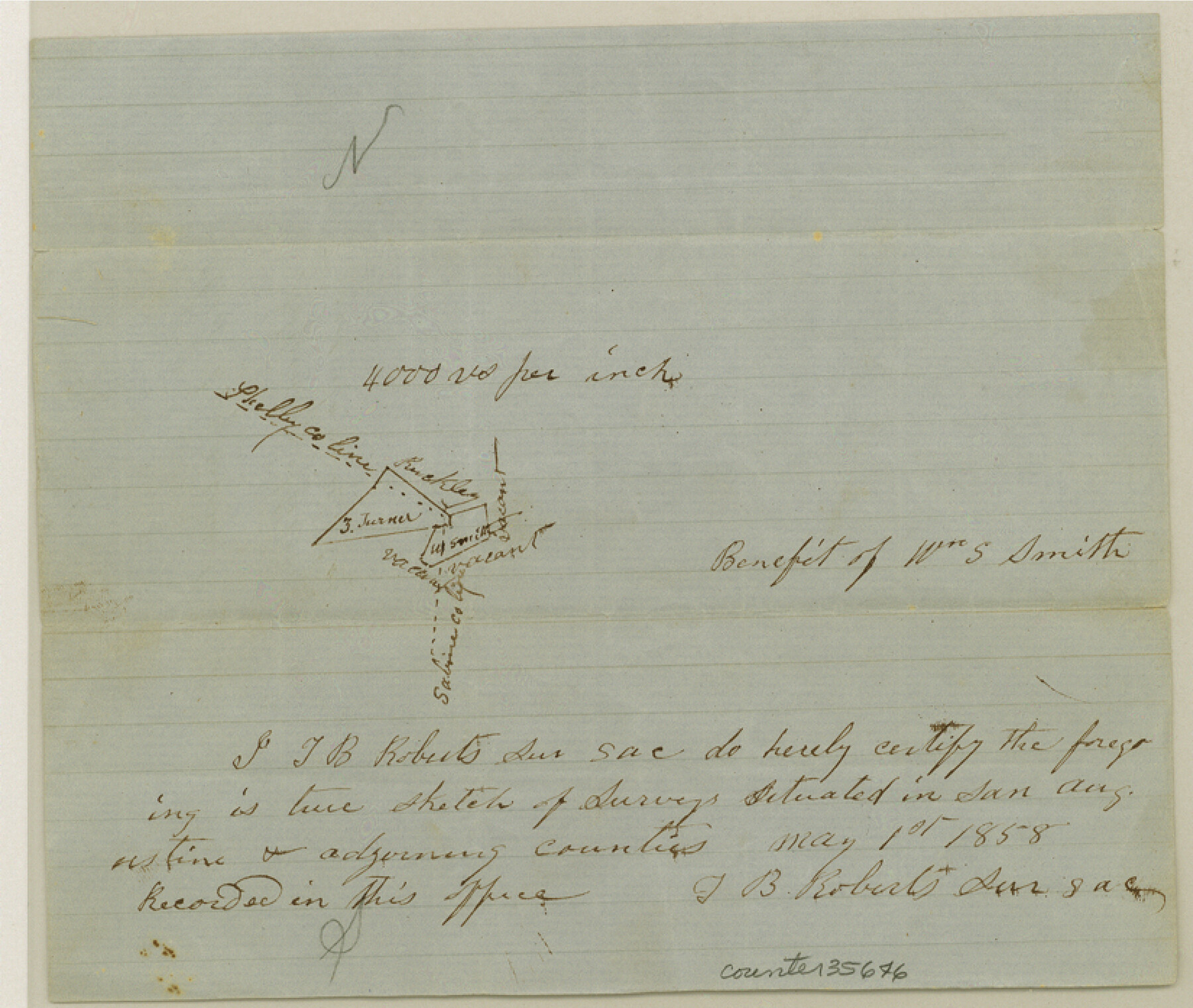
San Augustine County Sketch File 7
[Sketch of surveys at the intersection of Shelby, Sabine, and San Augustine Counties]
-
Map/Doc
35646
-
Collection
General Map Collection
-
Object Dates
5/1/1858 (Creation Date)
6/28/1858 (File Date)
-
People and Organizations
T.B. Roberts (Surveyor/Engineer)
-
Counties
San Augustine Shelby Sabine
-
Subjects
Surveying Sketch File
-
Height x Width
7.0 x 8.2 inches
17.8 x 20.8 cm
-
Medium
paper, manuscript
-
Scale
1" = 4000 varas
Part of: General Map Collection
Van Zandt County
![95662, Van Zandt County, General Map Collection](https://historictexasmaps.com/wmedia_w700/maps/95662.tif.jpg)
Print $20.00
- Digital $50.00
Van Zandt County
1972
Size 47.6 x 42.0 inches
Map/Doc 95662
Map showing the environs of Brazos Island, Texas
![72926, Map showing the environs of Brazos Island, Texas, General Map Collection](https://historictexasmaps.com/wmedia_w700/maps/72926.tif.jpg)
Print $20.00
- Digital $50.00
Map showing the environs of Brazos Island, Texas
Size 18.1 x 25.0 inches
Map/Doc 72926
Maps of Gulf Intracoastal Waterway, Texas - Sabine River to the Rio Grande and connecting waterways including ship channels
![61952, Maps of Gulf Intracoastal Waterway, Texas - Sabine River to the Rio Grande and connecting waterways including ship channels, General Map Collection](https://historictexasmaps.com/wmedia_w700/maps/61952.tif.jpg)
Print $20.00
- Digital $50.00
Maps of Gulf Intracoastal Waterway, Texas - Sabine River to the Rio Grande and connecting waterways including ship channels
1966
Size 14.6 x 22.2 inches
Map/Doc 61952
Brooks County Boundary File Index
![50808, Brooks County Boundary File Index, General Map Collection](https://historictexasmaps.com/wmedia_w700/pdf_converted_jpg/qi_pdf_thumbnail_15689.jpg)
Print $2.00
- Digital $50.00
Brooks County Boundary File Index
Size 8.6 x 3.1 inches
Map/Doc 50808
El Paso County Working Sketch 46
![69068, El Paso County Working Sketch 46, General Map Collection](https://historictexasmaps.com/wmedia_w700/maps/69068.tif.jpg)
Print $20.00
- Digital $50.00
El Paso County Working Sketch 46
Size 38.3 x 37.5 inches
Map/Doc 69068
Cameron County
![4752, Cameron County, General Map Collection](https://historictexasmaps.com/wmedia_w700/maps/4752-GC.tif.jpg)
Print $20.00
- Digital $50.00
Cameron County
1913
Size 28.9 x 32.1 inches
Map/Doc 4752
Freestone County
![1831, Freestone County, General Map Collection](https://historictexasmaps.com/wmedia_w700/maps/1831.tif.jpg)
Print $40.00
- Digital $50.00
Freestone County
1918
Size 48.9 x 42.0 inches
Map/Doc 1831
Presidio County Working Sketch 58
![71735, Presidio County Working Sketch 58, General Map Collection](https://historictexasmaps.com/wmedia_w700/maps/71735.tif.jpg)
Print $20.00
- Digital $50.00
Presidio County Working Sketch 58
Size 21.9 x 24.2 inches
Map/Doc 71735
Deaf Smith County Sketch File 8
![](https://historictexasmaps.com/wmedia_w700/pdf_converted_jpg/qi_pdf_thumbnail_70886.jpg)
Print $20.00
- Digital $50.00
Deaf Smith County Sketch File 8
1988
Size 24.3 x 32.9 inches
Map/Doc 11304
Plano General de la Ciudad de Mexico. Levantado Por el Teniente Coronel Don Diego Garcia Conde en el Año de 1793. Aumentado y corregido en lo mas notable Por el Teniente Coronel retirado, Don Rafael Maria Calvo En el de 1830
![95354, Plano General de la Ciudad de Mexico. Levantado Por el Teniente Coronel Don Diego Garcia Conde en el Año de 1793. Aumentado y corregido en lo mas notable Por el Teniente Coronel retirado, Don Rafael Maria Calvo En el de 1830, General Map Collection](https://historictexasmaps.com/wmedia_w700/maps/95354.tif.jpg)
Print $20.00
- Digital $50.00
Plano General de la Ciudad de Mexico. Levantado Por el Teniente Coronel Don Diego Garcia Conde en el Año de 1793. Aumentado y corregido en lo mas notable Por el Teniente Coronel retirado, Don Rafael Maria Calvo En el de 1830
1793
Size 19.7 x 21.8 inches
Map/Doc 95354
Live Oak County Working Sketch 7
![70592, Live Oak County Working Sketch 7, General Map Collection](https://historictexasmaps.com/wmedia_w700/maps/70592.tif.jpg)
Print $20.00
- Digital $50.00
Live Oak County Working Sketch 7
Size 24.9 x 37.6 inches
Map/Doc 70592
Webb County Working Sketch 10
![72375, Webb County Working Sketch 10, General Map Collection](https://historictexasmaps.com/wmedia_w700/maps/72375.tif.jpg)
Print $20.00
- Digital $50.00
Webb County Working Sketch 10
Size 23.7 x 20.0 inches
Map/Doc 72375
You may also like
Hall County Sketch File 17
![24816, Hall County Sketch File 17, General Map Collection](https://historictexasmaps.com/wmedia_w700/pdf_converted_jpg/qi_pdf_thumbnail_11567.jpg)
Print $22.00
- Digital $50.00
Hall County Sketch File 17
1889
Size 8.2 x 10.0 inches
Map/Doc 24816
Ellis Addition to the City of Lubbock, Being a Subdivision of a Part of the SW/4 of SW/4 Sec. 4, Blk. A
![92710, Ellis Addition to the City of Lubbock, Being a Subdivision of a Part of the SW/4 of SW/4 Sec. 4, Blk. A, Twichell Survey Records](https://historictexasmaps.com/wmedia_w700/maps/92710.tif.jpg)
Print $3.00
- Digital $50.00
Ellis Addition to the City of Lubbock, Being a Subdivision of a Part of the SW/4 of SW/4 Sec. 4, Blk. A
1952
Size 9.5 x 12.0 inches
Map/Doc 92710
Nueces County Rolled Sketch 43
![6883, Nueces County Rolled Sketch 43, General Map Collection](https://historictexasmaps.com/wmedia_w700/maps/6883.tif.jpg)
Print $20.00
- Digital $50.00
Nueces County Rolled Sketch 43
Size 23.6 x 31.8 inches
Map/Doc 6883
Glasscock County Rolled Sketch 5
![6016, Glasscock County Rolled Sketch 5, General Map Collection](https://historictexasmaps.com/wmedia_w700/maps/6016-GC.tif.jpg)
Print $20.00
- Digital $50.00
Glasscock County Rolled Sketch 5
1944
Size 41.4 x 33.7 inches
Map/Doc 6016
Sabine Pass, Texas
![69837, Sabine Pass, Texas, General Map Collection](https://historictexasmaps.com/wmedia_w700/maps/69837.tif.jpg)
Print $40.00
- Digital $50.00
Sabine Pass, Texas
1874
Size 32.2 x 53.2 inches
Map/Doc 69837
Edwards County Sketch File 9
![10443, Edwards County Sketch File 9, General Map Collection](https://historictexasmaps.com/wmedia_w700/pdf_converted_jpg/qi_pdf_thumbnail_7118.jpg)
Print $20.00
- Digital $50.00
Edwards County Sketch File 9
Size 16.9 x 37.8 inches
Map/Doc 10443
The Republic County of Jackson. September 17, 1838
![96185, The Republic County of Jackson. September 17, 1838, Nancy and Jim Tiller Digital Collection](https://historictexasmaps.com/wmedia_w700/maps/96185.tif.jpg)
Print $20.00
- Digital $50.00
The Republic County of Jackson. September 17, 1838
2020
Size 7.8 x 10.9 inches
Map/Doc 96185
Brewster County Rolled Sketch 92
![5250, Brewster County Rolled Sketch 92, General Map Collection](https://historictexasmaps.com/wmedia_w700/maps/5250.tif.jpg)
Print $20.00
- Digital $50.00
Brewster County Rolled Sketch 92
1950
Size 24.3 x 15.2 inches
Map/Doc 5250
Crockett County Sketch File 98
![19976, Crockett County Sketch File 98, General Map Collection](https://historictexasmaps.com/wmedia_w700/pdf_converted_jpg/qi_pdf_thumbnail_10528.jpg)
Print $8.00
- Digital $50.00
Crockett County Sketch File 98
1925
Size 12.5 x 8.9 inches
Map/Doc 19976
Polk County Sketch File 44
![34297, Polk County Sketch File 44, General Map Collection](https://historictexasmaps.com/wmedia_w700/pdf_converted_jpg/qi_pdf_thumbnail_13672.jpg)
Print $193.00
- Digital $50.00
Polk County Sketch File 44
1958
Size 9.4 x 11.0 inches
Map/Doc 34297
Bandera County Sketch File 24
![14014, Bandera County Sketch File 24, General Map Collection](https://historictexasmaps.com/wmedia_w700/pdf_converted_jpg/qi_pdf_thumbnail_9241.jpg)
Print $4.00
- Digital $50.00
Bandera County Sketch File 24
Size 9.3 x 8.3 inches
Map/Doc 14014
Crane County Sketch File 22
![10344, Crane County Sketch File 22, General Map Collection](https://historictexasmaps.com/wmedia_w700/pdf_converted_jpg/qi_pdf_thumbnail_7038.jpg)
Print $20.00
- Digital $50.00
Crane County Sketch File 22
1930
Size 30.6 x 31.1 inches
Map/Doc 10344