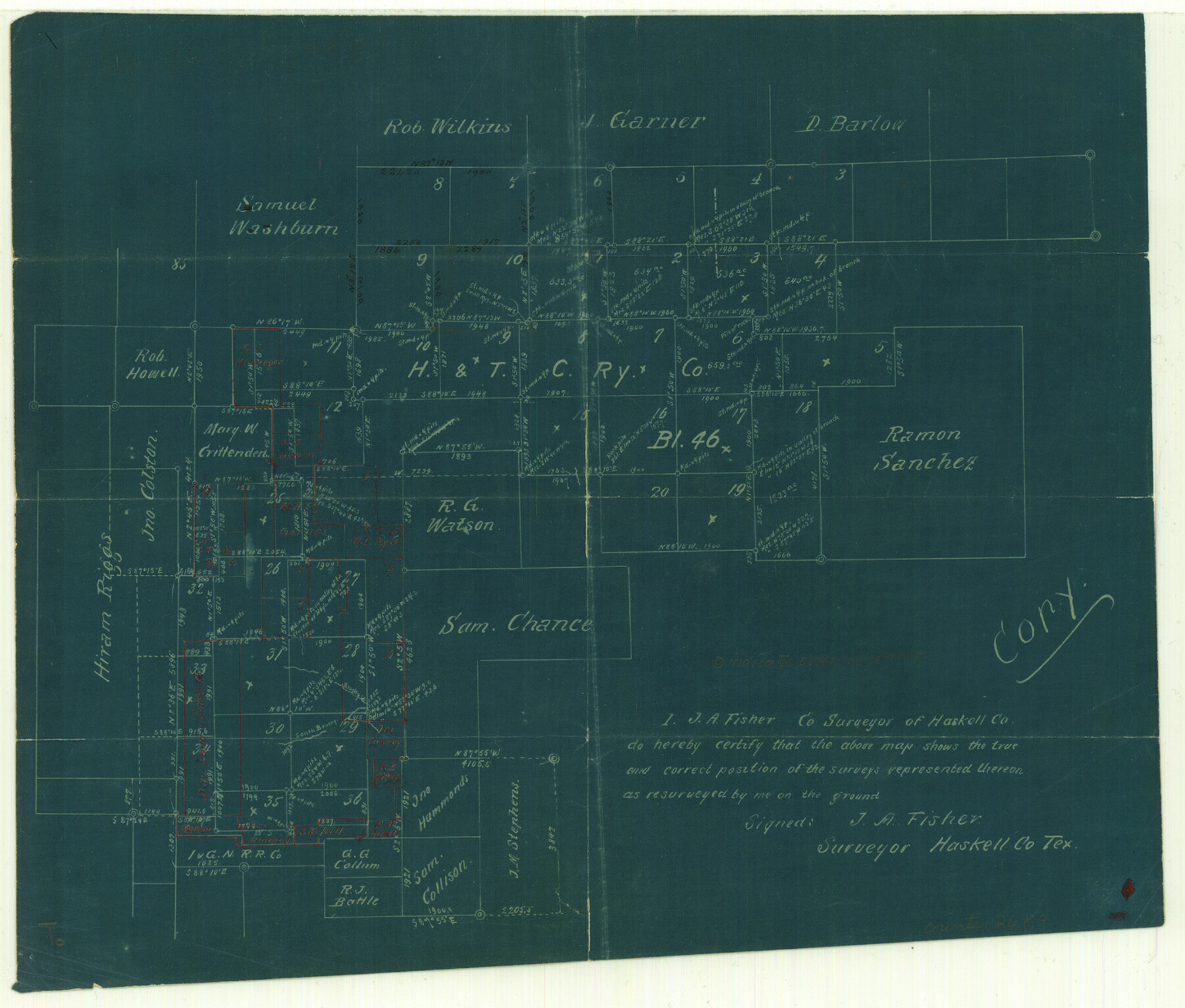
Haskell County Sketch File 1A
[Sketch of H. & T. C. RR. Co. Block 46]
-
Map/Doc
26119
-
Collection
General Map Collection
-
Object Dates
1899/8/23 (File Date)
-
People and Organizations
J.A. Fisher (Surveyor/Engineer)
-
Counties
Haskell Knox Baylor Throckmorton
-
Subjects
Surveying Sketch File
-
Height x Width
12.3 x 14.5 inches
31.2 x 36.8 cm
-
Medium
blueprint/diazo
-
Features
Brushy Creek
South Brushy Creek
Part of: General Map Collection
Amistad International Reservoir on Rio Grande 61

Print $20.00
- Digital $50.00
Amistad International Reservoir on Rio Grande 61
1949
Size 28.4 x 39.4 inches
Map/Doc 73346
Castro County Sketch File A

Print $20.00
- Digital $50.00
Castro County Sketch File A
1903
Size 25.8 x 19.4 inches
Map/Doc 11064

San Augustine and Sabine Counties

Print $20.00
- Digital $50.00
San Augustine and Sabine Counties
1881
Size 23.7 x 26.3 inches
Map/Doc 4012
Presidio County Working Sketch 130

Print $20.00
- Digital $50.00
Presidio County Working Sketch 130
1989
Size 22.1 x 43.1 inches
Map/Doc 71808
Calhoun County Rolled Sketch 14

Print $20.00
- Digital $50.00
Calhoun County Rolled Sketch 14
Size 21.9 x 40.1 inches
Map/Doc 5459
West Part of Edwards County

Print $20.00
- Digital $50.00
West Part of Edwards County
1975
Size 35.5 x 23.2 inches
Map/Doc 77271
Flight Mission No. CLL-1N, Frame 158, Willacy County

Print $20.00
- Digital $50.00
Flight Mission No. CLL-1N, Frame 158, Willacy County
1954
Size 18.4 x 22.1 inches
Map/Doc 87049
Moore County Rolled Sketch 12

Print $20.00
- Digital $50.00
Moore County Rolled Sketch 12
1919
Size 24.9 x 22.7 inches
Map/Doc 6828
Brazos River, Jones Bridge Special Map Sheet

Print $4.00
- Digital $50.00
Brazos River, Jones Bridge Special Map Sheet
1936
Size 29.8 x 28.2 inches
Map/Doc 65280
Flight Mission No. CRK-8P, Frame 118, Refugio County

Print $20.00
- Digital $50.00
Flight Mission No. CRK-8P, Frame 118, Refugio County
1956
Size 18.3 x 22.1 inches
Map/Doc 86973
Colorado County Sketch File 30

Print $14.00
- Digital $50.00
Colorado County Sketch File 30
1943
Size 14.1 x 8.6 inches
Map/Doc 18977
You may also like
Rio Grande, Raymondville Sheet

Print $20.00
- Digital $50.00
Rio Grande, Raymondville Sheet
1937
Size 37.3 x 37.9 inches
Map/Doc 65110
Zavala County Working Sketch 7

Print $20.00
- Digital $50.00
Zavala County Working Sketch 7
1948
Size 19.3 x 17.3 inches
Map/Doc 62082
Bastrop County Working Sketch 3

Print $20.00
- Digital $50.00
Bastrop County Working Sketch 3
1921
Size 22.9 x 15.4 inches
Map/Doc 67303
Hockley County

Print $20.00
- Digital $50.00
Hockley County
1954
Size 42.9 x 38.9 inches
Map/Doc 1856
General Highway Map, Victoria County, Texas

Print $20.00
General Highway Map, Victoria County, Texas
1940
Size 24.8 x 18.5 inches
Map/Doc 79268
Mason County Sketch File 23

Print $42.00
- Digital $50.00
Mason County Sketch File 23
1932
Size 11.2 x 8.8 inches
Map/Doc 30723
Flight Mission No. CON-4R, Frame 88, Stonewall County

Print $20.00
- Digital $50.00
Flight Mission No. CON-4R, Frame 88, Stonewall County
1957
Size 18.2 x 22.0 inches
Map/Doc 86992
Shackelford County Boundary File 7

Print $74.00
- Digital $50.00
Shackelford County Boundary File 7
Size 11.6 x 8.9 inches
Map/Doc 58671
Dallam County Sketch File 15

Print $18.00
- Digital $50.00
Dallam County Sketch File 15
1990
Size 14.4 x 9.0 inches
Map/Doc 20381
Nueces County Sketch File 31

Print $8.00
- Digital $50.00
Nueces County Sketch File 31
1907
Size 14.1 x 8.6 inches
Map/Doc 32601
Revised Sectional Map No. 3 showing land surveys in counties of Loving, Reeves and Culberson and portions of Winkler, Ward, Pecos and Jeff Davis, Texas

Print $20.00
- Digital $50.00
Revised Sectional Map No. 3 showing land surveys in counties of Loving, Reeves and Culberson and portions of Winkler, Ward, Pecos and Jeff Davis, Texas
Size 19.0 x 24.7 inches
Map/Doc 4478
University Land in Grayson County in Two Parts

Print $20.00
- Digital $50.00
University Land in Grayson County in Two Parts
Size 30.6 x 25.8 inches
Map/Doc 62965