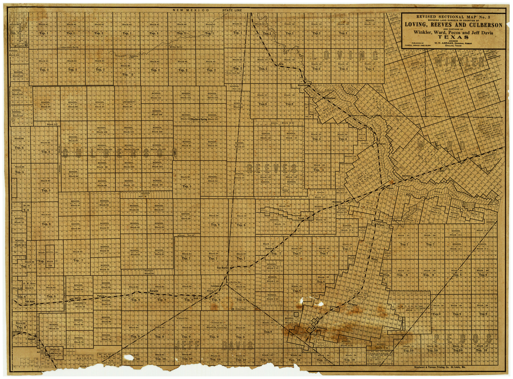
Revised Sectional Map No. 3 showing land surveys in counties of Loving, Reeves and Culberson and portions of Winkler, Ward, Pecos and Jeff Davis, Texas
-
Map/Doc
4478
-
Collection
Maddox Collection
-
People and Organizations
Canda, Drake, and Kloh (Publisher)
Woodward & Tiernan Printing Co. (Printer)
W.H. Abrams (Agent)
-
Counties
Winkler Ward Pecos Jeff Davis Loving Reeves Culberson
-
Height x Width
19.0 x 24.7 inches
48.3 x 62.7 cm
-
Medium
paper, etching/engraving/lithograph
-
Features
Gomez Peak
Boracho
Plateau
Wild Horse
Van Horn
Cullado
Haskell
Lobo
Kildugan Spring
Antelope Spring
Apache Spring
Levison
Phantom Lake
Balmorhea
Toyah Spring
Saragosa
Moran
Sargent
Toyah Lake
P&TVS
Screw Bean Spring
Rustlers Spring
Barstow
El Capitan
Independence Spring
Delaware Creek
Delaware Spring
Willow Spring
Pecos River
Orla
Riverton
Dixie Land
Patrole
Guadalupe Mountains
Quito
Pyote
Pecos
Hermosa
Toyah
Gomez
San Martine
San Martine Spring
Kent
Part of: Maddox Collection
Map of Trinity County

Print $20.00
- Digital $50.00
Map of Trinity County
Size 17.8 x 24.8 inches
Map/Doc 760

Map of the O-X Ranch in Cottle County, Texas

Print $20.00
- Digital $50.00
Map of the O-X Ranch in Cottle County, Texas
1916
Size 30.4 x 35.7 inches
Map/Doc 4439
Hunt County, Texas

Print $20.00
- Digital $50.00
Hunt County, Texas
1871
Size 25.8 x 19.4 inches
Map/Doc 462
Plat Town of Swearingen, Cottle Co., Texas

Print $20.00
- Digital $50.00
Plat Town of Swearingen, Cottle Co., Texas
1918
Size 39.8 x 30.6 inches
Map/Doc 513
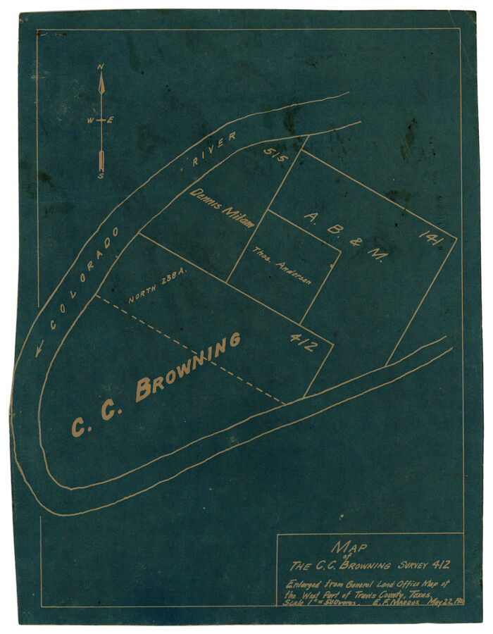
Map of the C.C. Browning survey 412 enlarged from General Land Office map of the west part of Travis County, Texas
Print $3.00
- Digital $50.00
Map of the C.C. Browning survey 412 enlarged from General Land Office map of the west part of Travis County, Texas
1920
Size 11.3 x 9.1 inches
Map/Doc 10752
Part of original sketch of Block "H" W. & N. W. Ry. Co. Cottle County

Print $20.00
- Digital $50.00
Part of original sketch of Block "H" W. & N. W. Ry. Co. Cottle County
Size 14.3 x 15.6 inches
Map/Doc 613
Map of Part of the YL Ranch

Print $20.00
- Digital $50.00
Map of Part of the YL Ranch
1917
Size 29.1 x 27.3 inches
Map/Doc 4442
[Mary L. Williams or Lydia Glasgow Survey, Bastrop County, Texas]
![572, [Mary L. Williams or Lydia Glasgow Survey, Bastrop County, Texas], Maddox Collection](https://historictexasmaps.com/wmedia_w700/maps/0572-1.tif.jpg)
Print $3.00
- Digital $50.00
[Mary L. Williams or Lydia Glasgow Survey, Bastrop County, Texas]
Size 11.9 x 15.6 inches
Map/Doc 572
Plat of Surveys in Hidalgo Co.

Print $20.00
- Digital $50.00
Plat of Surveys in Hidalgo Co.
Size 18.3 x 9.2 inches
Map/Doc 75548
Map of Fort Bend County, Texas

Print $20.00
- Digital $50.00
Map of Fort Bend County, Texas
1882
Size 23.0 x 25.7 inches
Map/Doc 434
Fayette County, Texas

Print $20.00
- Digital $50.00
Fayette County, Texas
1879
Size 19.9 x 23.0 inches
Map/Doc 419
You may also like
Boundary Between the United States & Mexico Agreed upon by the Joint Commission under the Treaty of Guadalupe Hidalgo

Print $20.00
- Digital $50.00
Boundary Between the United States & Mexico Agreed upon by the Joint Commission under the Treaty of Guadalupe Hidalgo
1853
Size 18.2 x 26.4 inches
Map/Doc 72883
Live Oak County Working Sketch 15

Print $20.00
- Digital $50.00
Live Oak County Working Sketch 15
1952
Size 23.8 x 22.6 inches
Map/Doc 70600
Flight Mission No. CRC-3R, Frame 201, Chambers County

Print $20.00
- Digital $50.00
Flight Mission No. CRC-3R, Frame 201, Chambers County
1956
Size 18.6 x 22.4 inches
Map/Doc 84856
Right of Way and Track Map Texas & New Orleans R.R. Co. operated by the T. & N. O. R.R. Co. Dallas-Sabine Branch

Print $40.00
- Digital $50.00
Right of Way and Track Map Texas & New Orleans R.R. Co. operated by the T. & N. O. R.R. Co. Dallas-Sabine Branch
1918
Size 25.8 x 56.1 inches
Map/Doc 64155
Wharton County Sketch File 6

Print $4.00
- Digital $50.00
Wharton County Sketch File 6
1877
Size 8.6 x 14.2 inches
Map/Doc 39923
Reagan County Sketch File 8

Print $20.00
- Digital $50.00
Reagan County Sketch File 8
Size 25.6 x 47.6 inches
Map/Doc 10584
Gulf Intracoastal Waterway, Tex. - Aransas Bay to Corpus Christi Bay - Modified Route of Main Channel/Dredging

Print $20.00
- Digital $50.00
Gulf Intracoastal Waterway, Tex. - Aransas Bay to Corpus Christi Bay - Modified Route of Main Channel/Dredging
1958
Size 30.8 x 42.8 inches
Map/Doc 61896
Travis County Appraisal District Plat Map 2_0404

Print $20.00
- Digital $50.00
Travis County Appraisal District Plat Map 2_0404
Size 21.5 x 26.4 inches
Map/Doc 94229
Flight Mission No. DAG-24K, Frame 42, Matagorda County

Print $20.00
- Digital $50.00
Flight Mission No. DAG-24K, Frame 42, Matagorda County
1953
Size 18.5 x 22.3 inches
Map/Doc 86529
[Surveys between the Sabine and Red Rivers made for titles under Radford Berry, Commissioner]
![14, [Surveys between the Sabine and Red Rivers made for titles under Radford Berry, Commissioner], General Map Collection](https://historictexasmaps.com/wmedia_w700/maps/14.tif.jpg)
Print $20.00
- Digital $50.00
[Surveys between the Sabine and Red Rivers made for titles under Radford Berry, Commissioner]
1835
Size 22.3 x 15.9 inches
Map/Doc 14
Knox County Working Sketch 2

Print $20.00
- Digital $50.00
Knox County Working Sketch 2
1913
Size 22.7 x 14.2 inches
Map/Doc 70244
Hemphill County Boundary File 3

Print $36.00
- Digital $50.00
Hemphill County Boundary File 3
Size 7.7 x 32.9 inches
Map/Doc 54630