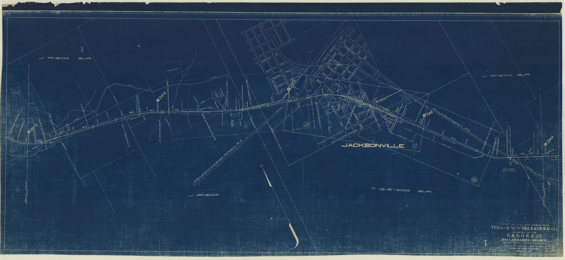
Right of Way and Track Map Texas & New Orleans R.R. Co. operated by the T. & N. O. R.R. Co. Dallas-Sabine Branch
Station 8968+10 to Station 9179+30
Z-2-45
-
Map/Doc
64155
-
Collection
General Map Collection
-
Object Dates
1918/6/30 (Creation Date)
-
Counties
Cherokee
-
Subjects
Railroads
-
Height x Width
25.8 x 56.1 inches
65.5 x 142.5 cm
-
Medium
blueprint/diazo
-
Scale
1" = 400'
-
Comments
See counter nos. 64150 through 64157 for all sheets.
-
Features
T&NO
SLS
I&GN
Jacksonville
Part of: General Map Collection
A Map of the Indian Territory, Northern Texas and New Mexico Showing the Great Western Prairies

Print $20.00
- Digital $50.00
A Map of the Indian Territory, Northern Texas and New Mexico Showing the Great Western Prairies
1844
Size 14.0 x 17.6 inches
Map/Doc 95700
Denton County Sketch File 10

Print $2.00
- Digital $50.00
Denton County Sketch File 10
1856
Size 8.5 x 13.5 inches
Map/Doc 20708

Coke County Sketch File 13a

Print $20.00
- Digital $50.00
Coke County Sketch File 13a
Size 20.3 x 19.5 inches
Map/Doc 11107
Sterling County Working Sketch 9

Print $20.00
- Digital $50.00
Sterling County Working Sketch 9
1980
Size 30.3 x 41.1 inches
Map/Doc 63991
Limestone County Working Sketch 24

Print $20.00
- Digital $50.00
Limestone County Working Sketch 24
1980
Size 28.9 x 31.6 inches
Map/Doc 70574
Pecos County Rolled Sketch 120

Print $40.00
- Digital $50.00
Pecos County Rolled Sketch 120
1945
Size 52.3 x 37.7 inches
Map/Doc 9723
Duval County Rolled Sketch 37

Print $20.00
- Digital $50.00
Duval County Rolled Sketch 37
Size 27.1 x 17.9 inches
Map/Doc 5752
The City of Austin and Suburbs

Print $40.00
- Digital $50.00
The City of Austin and Suburbs
1919
Size 120.7 x 41.2 inches
Map/Doc 88863
Fort Bend County State Real Property Sketch 11

Print $40.00
- Digital $50.00
Fort Bend County State Real Property Sketch 11
1986
Size 34.6 x 43.2 inches
Map/Doc 61685
Leon County Sketch File 37

Print $90.00
- Digital $50.00
Leon County Sketch File 37
1965
Size 11.2 x 8.8 inches
Map/Doc 29853
Edwards County Working Sketch 40

Print $20.00
- Digital $50.00
Edwards County Working Sketch 40
1949
Size 19.8 x 18.6 inches
Map/Doc 68916
You may also like
Lamar County State Real Property Sketch 1

Print $20.00
- Digital $50.00
Lamar County State Real Property Sketch 1
2013
Size 24.0 x 36.0 inches
Map/Doc 93660
[Location St. L. & S. W. R. R. Through Cherokee County]
![64042, [Location St. L. & S. W. R. R. Through Cherokee County], General Map Collection](https://historictexasmaps.com/wmedia_w700/maps/64042-1.tif.jpg)
Print $40.00
- Digital $50.00
[Location St. L. & S. W. R. R. Through Cherokee County]
Size 92.0 x 39.9 inches
Map/Doc 64042
Gray County Sketch File 12

Print $6.00
- Digital $50.00
Gray County Sketch File 12
1889
Size 17.0 x 8.3 inches
Map/Doc 24454
Nueces County Sketch File 32

Print $32.00
- Digital $50.00
Nueces County Sketch File 32
1907
Size 14.2 x 8.7 inches
Map/Doc 32605
Trails made and routes used by the Fourth U.S. Cavalry under command of General R.S. Mackenzie in its operations against hostile indians in Texas, Indian-Territory (now Oklahoma), New Mexico and Old Mexico during the period of 1871-2-3-4 and 5

Print $20.00
- Digital $50.00
Trails made and routes used by the Fourth U.S. Cavalry under command of General R.S. Mackenzie in its operations against hostile indians in Texas, Indian-Territory (now Oklahoma), New Mexico and Old Mexico during the period of 1871-2-3-4 and 5
1927
Size 37.0 x 34.2 inches
Map/Doc 62973
Hudspeth County Working Sketch 23

Print $40.00
- Digital $50.00
Hudspeth County Working Sketch 23
1967
Size 52.7 x 34.3 inches
Map/Doc 69650
[Surveys along the Sabine River made under G.W. Smyth, Commissioner]
![90, [Surveys along the Sabine River made under G.W. Smyth, Commissioner], General Map Collection](https://historictexasmaps.com/wmedia_w700/maps/90.tif.jpg)
Print $20.00
- Digital $50.00
[Surveys along the Sabine River made under G.W. Smyth, Commissioner]
1837
Size 13.9 x 17.0 inches
Map/Doc 90
Orange County Rolled Sketch CR

Print $20.00
- Digital $50.00
Orange County Rolled Sketch CR
Size 39.4 x 31.5 inches
Map/Doc 9653
Moore County Working Sketch 11

Print $20.00
- Digital $50.00
Moore County Working Sketch 11
1951
Size 33.1 x 29.8 inches
Map/Doc 71193
[Map of resurvey of H. & G.N. RR. Co. Blk. B2]
![89941, [Map of resurvey of H. & G.N. RR. Co. Blk. B2], Twichell Survey Records](https://historictexasmaps.com/wmedia_w700/maps/89941-1.tif.jpg)
Print $20.00
- Digital $50.00
[Map of resurvey of H. & G.N. RR. Co. Blk. B2]
1888
Size 36.6 x 37.7 inches
Map/Doc 89941
Marion County Sketch File 10

Print $4.00
- Digital $50.00
Marion County Sketch File 10
1867
Size 7.9 x 12.4 inches
Map/Doc 30579
Red River County Working Sketch 6

Print $20.00
- Digital $50.00
Red River County Working Sketch 6
1919
Size 20.1 x 20.9 inches
Map/Doc 71989